
-
 60666 Hits
-
 82.48% Score
-
 15 Votes
|
|
Mountain/Rock |
|---|---|
|
|
47.15770°N / 114.3559°W |
|
|
Missoula |
|
|
Hiking, Mountaineering, Scrambling, Skiing |
|
|
Spring, Summer, Fall, Winter |
|
|
7996 ft / 2437 m |
|
|
Overview
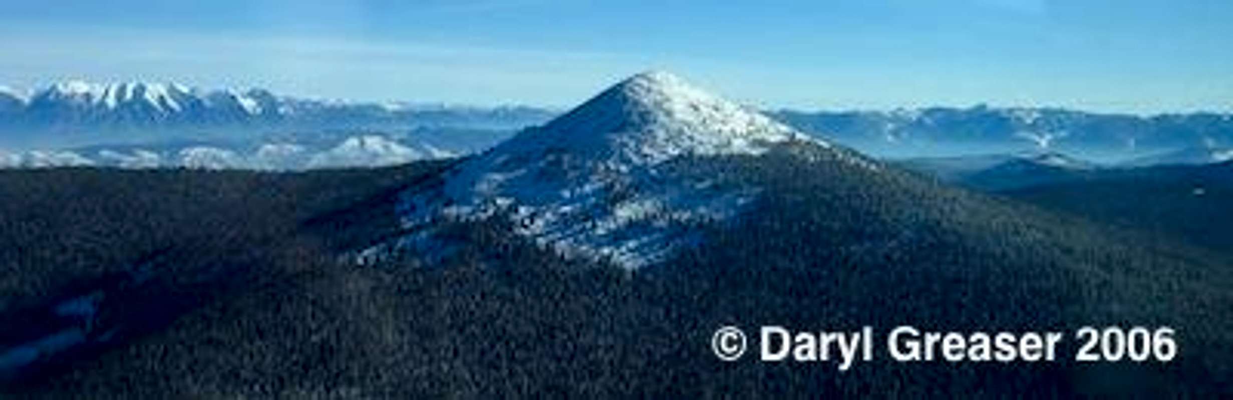
Ch-paa-qn from the south, Mission range on the left
Ch-paa-qn (pronounced "cha-pock-qwin"), or Squaw Peak, as it is historically named, is the familiar symmetrical pyramid west of Missoula, sitting high atop the Ninemile drainage on the Reservation Divide. The peak is located in the northern Bitterroot Range within the Coeur d'Alene Mountains, Lolo National Forest, Ninemile Ranger District. The Reservation Divide is the ridgeline that separates the Ninemile drainage to the south from the Flathead Reservation and River drainage to the north. The summit is also on the boundary of Missoula and Sanders' counties.
Currently, most locals are unfamiliar with the new name, which comes from the original Salish place name for the mountain meaning "gray, treeless mountain top." Initial translations of the word were thought to mean "shining mountain," however this was later disproved.
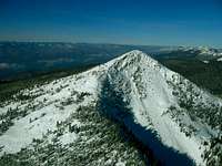
Ch-paa-qn is unique in that it is one of very few peaks in the state that possesses at least 4,000 feet of prominence. You don't have to know the details surrounding the math here to realize how "prominently" it stands out in the area - no other peak in the area is nearly as tall and it can be seen for many miles from many directions.
Ch-paa-qn is popular with locals, as the peak is fairly close and easy to reach, as well as providing magnificent views of the Mission, Couer d'Alene, Flathead, Swan, and Bitterroot mountains. The peak is popular with backcountry skiiers, as the numerous bowls, glades and chutes make for excellent opportunities. Most people visit Ch-paa-qn in the summer when the trail is snow-free. The Reservation Divide Trailhead at 6229 feet is typically accessible from spring to late fall.
Note: It is hard to determine exactly which mountain range this mountain belongs to, since none of the readily available maps demarcate the peaks within the Ninemile drainage. Looking at multiple map scales, Ch-paa-qn sits in a "no man's land" between the rest of the Couer d'Alene Mountains to the northwest, the Bitterroot Mountains to the south and southwest, the Salish Mountains to the north, and the Rattlesnake Wilderness/Garnet Range to the east. Pat Caffrey reported the peak as belonging to the Coeur d'Alene Mountains in the Climber's Guide to Montana, but remains a sub-range, at least to the layperson.
Getting There
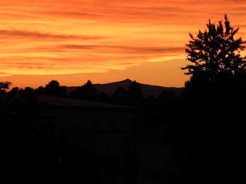 Sunset on Squaw from Missoula
Approaches via Nine Mile Ranger Station:
Take Interstate 90 west 23 miles from Missoula to Exit 82, Nine Mile Road. Turn north (right) for 1.4 miles to Remount Road. Turn north (right) onto Remount Road for 2.6 miles to a 4-way stop at the historic Nine Mile Ranger Station. Approaches described below start here:
Reservation Divide Trail #98: (Recommended Access Route)
2.8 miles one way, 90 minutes - 2 hour approach
2.8 miles one way, 90 minutes - 2 hour approach
Trailhead elevation: 6229
Elevation gain: 1767
From the Nine Mile Ranger Station, continue north (straight) on Remount Road north for 1.5 miles, then, continue right (lower road) on Edith Peak Road (FS# 476) for approximately 10 miles to the Reservation Divide boundary. A large parking area is available on the left at and the trailhead starts here.
Follow the well-marked trail over easy, rolling terrain for approximately two miles until the trail starts traversing west across the south face of the peak. Here, turn right and leave the trail and bushwhack up easy slopes onto the talus-covered southeast ridge. Boulder hop to the summit. You can also stay on the Reservation Divide Trail to around the south side of the summit pinnacle to where it meets the Sleeping Woman Trail (described below), a distance of 3 miles.
Notes: The 2001 Lolo National Forest (West Half) map has this trailhead incorrectly labeled as "Sleeping Woman." The 2011 Montana Delorme has this labeled as "Six Mile Trail" #98. A sign on Ch-paa-qn indicates this trail was formerly labeled "Trail 706"
Sleeping Woman (previously Squaw Peak) Trail #707: Trail cleared as of August 2022
2.5 miles one way, 2 1/2 hours or more on typical approach
Sleeping Woman (previously Squaw Peak) Trail #707: Trail cleared as of August 2022
2.5 miles one way, 2 1/2 hours or more on typical approach
Trailhead elevation: 5720 (509 feet lower than the Reservation Divide trailhead)
Elevation gain: 2276
Mileage log and directions:
0.0 Exit the Nine Mile exit from I-90 west of Missoula. Continue north
1.4 Turn right (north) onto Remount Road
4.0 Continue straight, past the Nine Mile Ranger Station on your left, on FS Road #476
5.5 Stay left (lower road on right is not the right way) on FS Road #5490
7.1 Turn left (west) at junction, back on FS Road #476 toward Kreis Pond (Butler Creek Road on some maps)
7.7 pass Kries Pond FS Road #2176 on left (continue straight), taking next right
8.2 Turn right (north) on FS Road #2178 (unmarked). This is the first right past Kries Pond (if heading west)
11.8 pass road #17430 on your left. Continue straight. Prepare your high-clearance 4WD for a workout and expect scratches. The road continues into what is now the course of the stream bed.
14.5 Trailhead at 5720 feet is a wide spot in the road with room for perhaps 6-8 vehicles. The road appears to continue, however rough, a short ways but with minimal elevation gain. (The author did not inspect the road beyond the trailhead) - considering the required bushwhacking, park at the TH.
From the trailhead, follow trail #707 north from the east end of the parking lot, over a nice, gradual climb for 2 miles to the trail junction. From here, bear west (left) and follow the trail onto talus and the summit pinnacle. Otherwise, this appears to be a fantastic trail with a sub-two-hour climb to treeline.
The 2011 Montana Delorme labels the road to the trailhead "Stony Creek Road."
Kennedy Creek Trail (#746)
8 miles one way
Kennedy Creek Trail (#746)
8 miles one way
Trailhead Elevation: 5545
Elevation gain, overall: 2451
Location: 47.1656, -114.4377
From the Ninemile Ranger Station, turn left on #393 which joins with 5511 to form road 412 Ninemile Road after a couple miles. About ~4 miles turn north (right) onto Butler Creek Road #456. Continue for 2, 2 1/2 miles and turn left (northwest) onto Road 5507 which leads you to the trailhead in another 4 or so miles. There is a wide turn out with parking for several vehicles, according to satellite images.
Note:This route is unknown to the author. Please post a route description, addition/correction, or PM the author if you are familiar with this approach.
Any travel within the Flathead Reservation (north side of the peak or divide, including all skiing on the north side) requires a Reservation Hiking Permit. These are easy to obtain at sporting goods stores throughout the Mission and Flathead Valleys, as well as Missoula and Thompson Falls, or you can call the Confederated Salish and Kootenai Tribal Recreation Department in Pablo, at (406) 675-2700.
The license is $15 per season, and expires every year on the last day of February —whether you purchase yours in March, May, or December, it expires the end of February.
The name Squaw Peak has appeared on Federal maps since 1959 and on County maps since 1958. As early as 1863, Captain John Mullan referred to the summit as Skiotah Peak, and in 1918, that name was made official by the BGN. However, one year later, that decision was reconsidered and the name Squaw Peak was made official. The 1919 BGN workcard indicated that the latter name was applied to the Lolo National Forest map, although the date of that map was not noted.
Squaw Peak was intially proposed to be renamed "Sleeping Woman Mountain," however after months of deliberations between government officals, the name "Cpaaqn" was suggested. The proponents reported that Cpaaqn is “the historical/aboriginal Salish-Pend d’Oreille place name” for the summit, but they were willing to submit the anglicized form Ch-paa-qn and to add the generic “Peak”.
The Montana House Bill 412 Advisory Committee, which was created to address the issue of removing the word “squaw” from the geographic names of Montana, recommended approval of the proposal. The government of Missoula County had also endorsed the change. The government of Sanders County indicated it understood the proponents’ desire to change the name, but expressed some concern that the local population would have difficulty pronouncing the Salish name. They suggested “ch-paa-gn Peak [sic] be the designated name and “Shining Peak” be put in parentheses below. Many tourists/people would find the name ch-paa-gn and interpretation fascinating”.
The Montana State Board on Geographic Names, after determining that the State’s Department of Natural Resources and Conservation (DNRC)/Water Resources Division had no objection to the change and the DNRC Trust Land Management Division supported the change, recommended approval of the name Ch-paa-qn Peak. The Coeur d’Alene Tribe, which is Federally-recognized, endorsed the change, as did the USDA Forest Service.
Note:This route is unknown to the author. Please post a route description, addition/correction, or PM the author if you are familiar with this approach.
 ski central ski central |
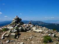 summit cairn summit cairn |
 east ridge east ridge |
|---|
Camping and Red Tape
The usual FS restrictions apply when camping in the forest. There is no camping at the trailhead. There are several official FS campgrounds nearby, the nearest being popular (and free!) Kreis Pond campground.Any travel within the Flathead Reservation (north side of the peak or divide, including all skiing on the north side) requires a Reservation Hiking Permit. These are easy to obtain at sporting goods stores throughout the Mission and Flathead Valleys, as well as Missoula and Thompson Falls, or you can call the Confederated Salish and Kootenai Tribal Recreation Department in Pablo, at (406) 675-2700.
The license is $15 per season, and expires every year on the last day of February —whether you purchase yours in March, May, or December, it expires the end of February.
A changing world, responding to culturally sensitive issues
"Squaw Peak" is a common name in Montana: Missoula, Ravalli, Sanders, and Sweet Grass counties ALL contain a "Squaw Peak." Additionally, there are "Squaw Peaks" all over the country. In recent times, however, there have been a widespread movement to rename some of the controversial place names found on maps of the United States. For example, "Whorehouse Meadows" has been renamed "Naughty Woman Meadows." The word "Squaw" appears in numerous place names and is considered offensive by most recognized tribal communities.The name Squaw Peak has appeared on Federal maps since 1959 and on County maps since 1958. As early as 1863, Captain John Mullan referred to the summit as Skiotah Peak, and in 1918, that name was made official by the BGN. However, one year later, that decision was reconsidered and the name Squaw Peak was made official. The 1919 BGN workcard indicated that the latter name was applied to the Lolo National Forest map, although the date of that map was not noted.
Squaw Peak was intially proposed to be renamed "Sleeping Woman Mountain," however after months of deliberations between government officals, the name "Cpaaqn" was suggested. The proponents reported that Cpaaqn is “the historical/aboriginal Salish-Pend d’Oreille place name” for the summit, but they were willing to submit the anglicized form Ch-paa-qn and to add the generic “Peak”.
The Montana House Bill 412 Advisory Committee, which was created to address the issue of removing the word “squaw” from the geographic names of Montana, recommended approval of the proposal. The government of Missoula County had also endorsed the change. The government of Sanders County indicated it understood the proponents’ desire to change the name, but expressed some concern that the local population would have difficulty pronouncing the Salish name. They suggested “ch-paa-gn Peak [sic] be the designated name and “Shining Peak” be put in parentheses below. Many tourists/people would find the name ch-paa-gn and interpretation fascinating”.
The Montana State Board on Geographic Names, after determining that the State’s Department of Natural Resources and Conservation (DNRC)/Water Resources Division had no objection to the change and the DNRC Trust Land Management Division supported the change, recommended approval of the name Ch-paa-qn Peak. The Coeur d’Alene Tribe, which is Federally-recognized, endorsed the change, as did the USDA Forest Service.
whitebark - Aug 28, 2022 11:23 am - Hasn't voted
Sleeping Woman Trail has been repairedThe Sleeping Woman Trail #707 has been repaired, and is free of downed logs as of August 2022. However, the access road is as bad as ever..