
|
|
Mountain/Rock |
|---|---|
|
|
46.33622°N / 114.02385°W |
|
|
Ravalli |
|
|
Hiking |
|
|
Spring, Summer, Fall, Winter |
|
|
4984 ft / 1519 m |
|
|
Overview
First time up the "C" Hill.
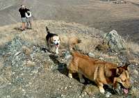
Although not exactly "back country", Chaffin Butte near Corvallis is a sweet little bald that adds interest to the east side of the Bitterroot Valley. It’s only a few minutes drive from our home so my husband, Michael, and I climb it frequently. This 1.8 mile round trip gains about 1,000 feet and is perfect for our dogs who are getting too old for long hikes or for out-of-town visitors who want a "mountain experience" but aren’t quite in shape for the real thing.
We were introduced to the trail in March, 2005 by a neighbor who showed us where to park on Soft Rock Road to access the trail. Unfortunately since it’s so easily accessible, the lower part of the trail is (mis)used as an ad hoc target range and often littered with animal bones, beer cans, and other trash. However, the last few times we’ve climbed it, we’ve noticed a slight decrease in the amount of refuse - probably due to new homes being built in the area.
"What took you so long?"
The butte is known to the locals as the "C" Hill for the somewhat faint outline of the letter "C" representing Corvallis. Each year the high school seniors arrange rocks next to the "C" to indicate their graduating year.
Along with Kootenai Canyon in the Bitterroots, this butte was a much-used site by the young men of the Bitterroot Salish tribe for their vision quests.
The path is easily discernable as it winds through fragrant sagebrush and starts to climb. In the spring, you can spot bitterroots and other wildflowers. A few small rock outcroppings and ubiquitous ponderosa pines soon give way to the open space and the steadily climbing trail. It’s steep enough to get the heart pumping and the sweat flowing.
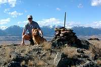
New and improved Cairn
Michael always likes to have positive visual reinforcement on the top, so he "re-engineered" the existing small cairn and adds a few stones each time we summit. On a clear day, the 360 degree view is all the positive reinforcement I need although the distant sounds of barking dogs, traffic on Highway 93, and chainsaws remind me I’m not too far from home.
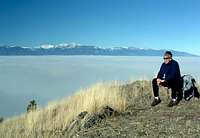
Unknown hiker waiting for his Thanksgiving Feast
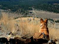
To earn our Thanksgiving feast in 2005, we had a particularly memorable climb up the "C" hill. A sun-blocking inversion had engulfed the valley for days so while our turkey was roasting we made the short trek. About ¾ of the way up, we broke through the shroud of fog to witness a dazzling display of sunlight and a cobalt-blue sky. The inversion obscured all signs of civilization in the valley below and the peaks of the Bitterroot Mountains seemed to rise out of a lake of clouds. Michael and I speculated that perhaps this is what Glacial Lake Missoula might have looked like. It was magical.
Granted, it’s not especially impressive or imposing but the "C" Hill provides a nice little workout close to home. It’s the perfect antidote to wintertime cabin fever, a good hike for dogs, children, and "flatlander" guests. As we discovered climbing above the inversion, even the most mundane little butte can, on occasion, offer a bit of mountain magic.
Getting There
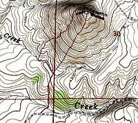 3D Topo of C-Hill Route 3D Topo of C-Hill Route |
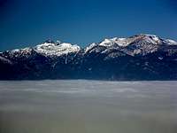 St Mary & The Heavenly Twinsshow themselves above theinversion. St Mary & The Heavenly Twinsshow themselves above theinversion. |
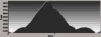 Profile of C-Hill Route Profile of C-Hill Route |
|---|
From blinker light in Corvallis: Go east on Willow Creek Road for 2.3 miles to intersection of Willow Creek and Coal Pit.
Continue straight ahead on Coal Pit .2 miles.
Turn left onto Summerdale (first road to left) and drive .75 miles, to Soft Rock.
Turn right onto Soft Rock (east) and stay left at the split in 1.2 miles.
Continue on Soft Rock for an additional .25 miles to the trailhead. Parking is right along the road.
Red Tape
This area is a mixture of state and private land with unmarked boundaries.
UPDATE JULY 24, 2020 from The owners and residents of Chaffin Butte Ranch:
The Chaffin Butte Trail, the “C” hill, will be closed on September 1st, 2020 for an indefinite period of time. The trail has been used and abused as well as the land around it. It is on private property 850 private acres surround it. We know there are conscientious people who hike the “C,” but now hikers are all over the place making new trails and disturbing the land and making it a breeding place for weeds. Dogs are chasing wildlife and the trail is being tromped on day and night.
So, sadly because of the disrespect, we’ll close. There will be fines imposed for trespassing. So, we will be closed for restoration, weed management, and wildlife management. There are 450 acres of State land to the south of Softrock Rd. open to the public.
Camping
No camping is allowed.