
-
 7653 Hits
-
 81.02% Score
-
 13 Votes
|
|
Mountain/Rock |
|---|---|
|
|
32.71666°N / 17.00147°W |
|
|
Download GPX » View Route on Map |
|
|
Hiking |
|
|
Spring, Summer, Fall, Winter |
|
|
4711 ft / 1436 m |
|
|
Overview
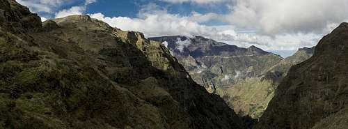 Chao dos Terreiros seen from Boca dos Corgos Chao dos Terreiros seen from Boca dos Corgos |
Chao dos Terreiros is a mountain located on Madeira's central spine, the ridge between the Encumeada and Curral das Freiras Valleys. It is located to the side of the main ridge and thus does not see as many visits as its bigger neighbour Pico Grande. Still the mountain occasionally attracts the attention of hiking groups as it offers wonderful close-up views to the giant Pico Grande west and south faces as well as Madeira's Central Range and the high plateau Paul da Serra as well.
Chao dos Terreiros is a tabe top mountain with easy access from the south side while an impressive face drops off in the north. It is located right between Boca da Corrida and the village of Fontes, which both serve as trailheads for the mountain. If you want you can hike back and forth in a loop trail but the better alternative is staying on the ridge which heads from Chao dos Terreiros across neighbouring Eira do Ribeiro to Boca da Corrida. It is a little hiked ridge but offers fantastic views.
 |  |  |
The area is used for cattle grazing and consequently fences have been drawn across it. On one hand these fences are good for orientation on the table-top plateaus on the other they obstruct the barely visible paths. One of these fences - a surprisingly solid one - is located on the western and of Terreiros' summit plateau. It's a bit of a challenge to find the best spot to cross it (it is at the north-western end). Another one lines the steep path from Eira do Ribeiro helping you to get to or from the saddle between the two mountains.
 |  |  |
NB to the GPX-File: we lost our way twice upon returning from Boca da Corrida and thus would recommend to choose the northern route between the saddle and Chao dos Terreiros.
Getting There
 Pico Ferreiro, Pico Grande, Pico Serradinho, Chao dos Terreiros seen from Paul da Serra
Madeira can be reached from any of the major European airports. There are almost no regular flights (with the exception of some portugese airports) but quite a lot of charter flights. As mentioned above, there are two trailheads for Chao dos Terreiros, one at Boca da Corrida, one at the village Fontes.
Boca da Corrida:
Follow motorway ER101 from the airport to the west. At the exit Estreito de Câmara de Lobos get off an start headsing up to the village. Drive through but remain in the western part of the village (always going up) until you get to Achado. Drive through there as well. The road gets steeper and steeper and ends at Boca da Corrida.
Fontes:
Also follow the motorway ER101 to the exit Campanario. Turn right and head through the steep tunnel to Boa Morte. Right after the tunnel you reach an intersection. Boa Morte is to the left, instead take the right hand road which takes you through Ribeira Funda and Lombo Furado to Fontes. There is a small parking space in fromt of the bar.
Routes
 Chao dos Terreiros, Paul da Serra, Pico Cavalho, Pico Grande
From Boca da Corrida:
Follow the Pico Grande Route for a few steps, then turn left onto a dirt road. Follow the dirt road but try to hike up the ridge to your right as soon as possible. Always stay on the ridge, which takes you slowly to Eira do Ribeiro. Head across the mountain into a saddle, from where you follow the cattle fence to the top of Chao dos Terreiros.
Alternative: Stay on the dirt road until you have passed Eira do Ribeiro. Now a path leads to the same saddle and Chao dos Terreiros.
From Fontes:
From the bar take the village road, which climbs directly to the hills. It leads to Pico da Cruz a good lookout to Paul da Serra and Encumeada Pass. Stay on the road which heads for the saddle between Pico da Cruz and Chao dos Terreiros. Here a second road joins from below. Together they lead to the south side of Terreiros where they end only a few hundred metres shy of the summit. There is no path. Follow the cattle fence until you almost reach the north face drop. Here you can cross it easily and head up to the summit.
Red Tape
There's no red tape there. Take care of the cattle around the summit. Losing our way we ended up in a cattle corral with cows and their calves and twice had to retreat quickly when we goot between them.Accommodation
You can find a lot of hotel rooms and apartments on Madeira. Either visit the next travel office or do an internet search. The island is small, all trailheads can be reached by car in an hour from almost anywhere on the island. Most accomodation can be found in the south of the island near Funchal and Camara de Lobos.Weather Conditions
  |
Weather conditions cannot be predicted accurately. Madeira is located in the trade wind zone. You almost always encounter northeastern winds which carry a lot of humid air. Being forced to climb to higher altitudes this moisture condenses into clouds. This in return means that most of the time the northern part of the island is covered in clouds from altitudes of 1000m through 2000m.
The mountains themselves - being of the same altitude -finally stop the clouds so that on their southeastern slopes the clouds "run out". Look at the pictures - it looks like the clouds creeping over the weather divide. Boca da Encumeada - being some 500m lower than the surrounding summits - is a gateway for the clouds from north to south. Thus it very often is covered in mist. Unfortunately all of the major peaks of Madeira lie around the weather divide, sometimes within, sometimes just out of the clouds.
The following table shows weather data for Funchal on the southern coast. Be careful with these data if you want to climb the summits...
| Month | Jan | Feb | Mar | Apr | May | Jun | Jul | Aug | Sep | Oct | Nov | Dec |
| Avg. day temp.[°C / °F] | 16 / 61 | 16 / 61 | 17 / 63 | 20 / 68 | 24 / 75 | 27 / 81 | 29 / 84 | 29 / 84 | 27 / 81 | 23 / 73 | 21 / 70 | 17 / 63 |
| Avg. night temp.[°C / °F] | 9 / 48 | 9 / 48 | 10 / 50 | 12 / 54 | 15 / 59 | 19 / 66 | 21 / 70 | 22 / 72 | 19 / 66 | 16 / 61 | 13 / 55 | 11 / 52 |
| Water temp.[°C / °F] | 16 / 61 | 15 / 59 | 16 / 61 | 16 / 61 | 19 / 66 | 22 / 72 | 24 / 75 | 25 / 77 | 24 / 75 | 23 / 73 | 20 / 68 | 17 / 63 |
| Rainy days | 12 | 7 | 8 | 4 | 2 | 1 | 0 | 0 | 2 | 6 | 6 | 10 |
Maps & Books
Maps
- Madeira
Tour & Trail Map
Discovery Walking Guides
1:40000
ISBN: 190494678X
Books
My recommendation is a guidebook by Rother Verlag, available in several languages. The book is an excellent hiking guide covering all the interesting areas of the island. Since it comes with small maps for each excursion it might even be used without a map to support them.
- Madeira
Rolf Götz
Rother Verlag
ISBN 978-3-7633-4811-4 (English)
ISBN 978-3-7633-4274-7 (German)
ISBN 978-3-7633-4910-4 (French)
ISBN 978-3-7633-4297-6 (Portugese)
ISBN 978-3-7633-4708-7 (Spanish)