
|
|
Route |
|---|---|
|
|
38.52030°N / 113.2876°W |
|
|
Hiking, Mountaineering, Scrambling |
|
|
Spring, Fall |
|
|
Most of a day |
|
|
Class 2+ |
|
|
Overview
This route climbs the mountain via the east side and from near Morehouse Spring. Because the route follows a 4wd track and old power cable, it is easy to find.It is a steep route, gaining 1900 feet from the end of the 4wd track to the summit in 1.1 miles. If you begin the climb at the Charcoal Kilns, the route is 6.6 miles round trip with about 3000 feet elevation gain.
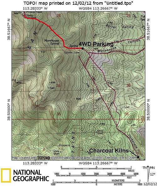 Frisco Peak-east side. The route marked was drawn from memory and the route line is approximate. Cars will have to be parked near the Charcoal Kilns.
Getting There
From the town of Milford, drive west along State Highway 21. Between Mile Markers 65 and 64, turn north onto a gravel road. After a short distance, turn left onto the gravel road that follows Carbonate Gulch. This is a good road to the Carbonate Mine, but the road becomes rougher after the mine. If you have a car, park at the Charcoal Kilns. If you have a 4wd vehicle, you can continue up the road to near Morehouse Spring.Route Description
From the Charcoal Kilns, walk or drive the 4wd road towards the mountain. You have a choice of two 4wd roads (see map) that lead you in the vicinity of Morehouse Spring and both will get you there (we took the west one). When the main 4wd road turns sharply east and follows the rim above Morehouse Canyon, turn left/west (see map) and follow this side track to near Morehouse Spring.There are two springs marked on the map, but neither has much water during the drier parts of the year, so don’t plan on tanking up with water here. Most of the water is piped to somewhere else.
Just above the spring is an old power cable lying on the ground. Following this power cable makes a good, albeit steep route to the summit. The going is steep and rugged, but there are no major obstacles and there isn’t any bushwhacking.
The summit is father than it looks, but once on top the views are really nice. It is recommended that you return the same way since it’s more interesting than following the summit road down.