

-
 22092 Hits
-
 85.87% Score
-
 21 Votes
|
|
Mountain/Rock |
|---|---|
|
|
45.15610°N / 117.5089°W |
|
|
8656 ft / 2638 m |
|
|
Overview
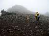
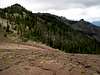
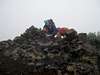
China Cap is a prominent peak located in the southwest corner of the Eagle Cap Wilderness and the Wallowa Mountains of Oregon. According to the Mazamas List of 100 Highest Peaks Of Oregon, China Cap is the 50th tallest peak in the state (there is some debate as to how accurate this list is). USGS map of the area shows China Cap to be a triangular-based pyramid. This however is not the impression one gets on the (standard) hike in where mountain appears as a flattened out ridge.
 |  |  |
Getting There
Unless you're lucky enough to be a resident of one of the charming little towns nearby, chances are you'll be coming in from Interstate 84.
Coming in from the west (from Portland direction):
Take I84 to exit 265 2 miles east of LaGrande, OR. Follow OR highway 203 towards Union, OR (approx. 14 miles). Stay on 203 through Union and drive (approx. 11.4 miles) to signed turn off for Catherine Creek Lane or FSR 7787 (turn off is between mile posts 11 and 12 on 203). Turn left onto the Forest Service Road.
Coming in from the east (Boise direction):
Take I84 to exit 298 a few miles west of Baker City, OR. Follow highway 203 towards (and through) the town of Medical Springs, OR for approximately 29 miles. Between mile posts 11 and 12, look for a signed turn off for Catherine Creek Lane. Turn right onto that road.
Follow the FS road for about 4.2 miles from the highway (you'll pass what looks like another major FS road on your right heading off across the bridge at about 3 miles - this is a dead end). Turn right (signed) onto FSR 7787 in the driection of Buck Creek Trailhead. Follow this road for 3.9 miles (passing a fork, stay left) to a unsigned fork. Take the left turn off and follow it for 0.3 miles to a large dirt parking lot (latrine facility available).
Red Tape
The North West Forest Pass is required to park at the trailhead ($5/day or $30/year). A self-issue free backcountry permit can be picked up at the trailhead (link taken from Brian Jenkins' page).
Dogs are allowed within the Eagle Cap Wilderness - keeping them leashed is required; packing out their waste is strongly encouraged.
When To Climb
The trailhead lies at 5500 feet above sea level. Standard climbing season would most likely run from June until the first snows arrive (generally late October) in the fall.
 |
Camping
Camping at large is allowed within the Eagle Cap Wilderness but is prohibited within 200 feet of streams/lakes. As always, please apply the leave-no-trace rules.
Mountain Conditions
Wallowa Mountains Visitor Center
(541) 426-5546 TDD (541) 426-5609 and
FS_Information
(the link was taken from rfbolton's Eagle Cap page.)
Guide Books
Barstad's guide includes a description of the climbing route up China Cap. Sullivan's book gives no information on the climb itself but gives very good directions to the TH as well as nice hike descriptions to Burger Pass.
rpc - Sep 13, 2004 11:53 pm - Hasn't voted
Untitled CommentAlways appreciate the help (and have been adding those in also :)
I'll incorporate the coords and thanks!!
hgrapid - Sep 13, 2004 11:44 pm - Voted 10/10
Untitled CommentRPC, you always have excellent pages, but I just wanted to make it easier on you, and I found the exact topo marks. Here you go.
lat= 45.1561111111111
lon= -117.508888888889
rpc - Sep 13, 2004 11:53 pm - Hasn't voted
Untitled CommentAlways appreciate the help (and have been adding those in also :)
I'll incorporate the coords and thanks!!