Intro
Orizaba has been on my list of international adventures for quite some time. It is a logical stepping stone to grander plans. With my only above 14K’ experience being on Kili some 7 years ago, it was prudent to test the waters at high altitude again. My experience on Kili was good, but I didn’t feel as strong on summit day as I would have liked. My friends Dave and Jane Schmid had a trip booked for late December, but I wasn’t sure I could pull off the vacation days. Since the trip was wrapped around Christmas weekend, it would only require 4 days off. The bonus for this trip would be 17er Iztaccihuatl on a day’s rest if the weather cooperated. I signed up with a little over a month to plan, and it was a decision I wouldn’t regret!
There were 7 of us, but we had 3 different travel itineraries. Dave, Jane, and I elected to use the shuttle services of Antonio Juarez Guzman for travel to the Canchola’s hostel in Tlachichuca. We also used him for transport to Izta and back to Mexico City. Although the bus system would have been about 1/3rd of the cost, the convenience was worth it. We didn’t have to worry about our gear getting stolen and were able to pickup groceries very conveniently. Antonio and his employee Joel were very reliable for the duration of the trip and are highly recommended.
Initially we were planning on spending the first night in Mexico City, but we ended up going straight to Tlachichuca the first night so we could have 2 days of acclimatization hikes from the hut. Your odds of success are higher if you have enough time to spend a couple nights at the hut. The rest of our team had a full day less to acclimate. This benefit is especially important for flatlanders. We met a climber from Indiana who came straight to Orizaba and went for the summit the next morning. He got altitude sickness after about 1500’ vertical!
We arrived at the Canchola’s just in time for dinner and had a relaxing evening as we sorted out our gear for the adventure ahead. The Canchola’s are wonderful hosts who go out of their way to make you feel right at home.
This was my first visit to real Mexico outside of border towns, and it really made me feel blessed to live in America with all of the modern amenities we enjoy. It was a joy to see how the people of Mexico value their families and how friendly they were to us. I only know a few words of Spanish, but it was fun to interact with them throughout the trip. My mom’s family were missionaries in Guatemala and El Salvador, so it was nice to experience the culture personally. I can see why they enjoyed the people down there despite the risks they faced.
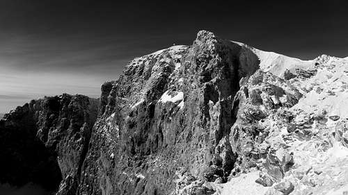
Pico de Orizaba
Day 1- Acclimate hike to 15560’
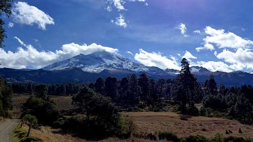
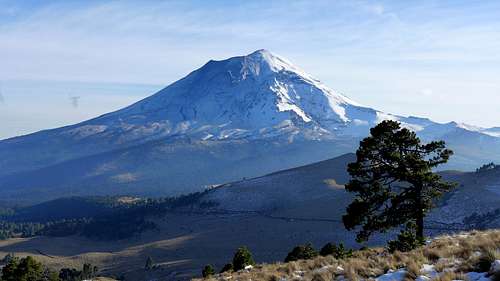
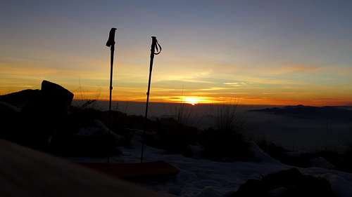
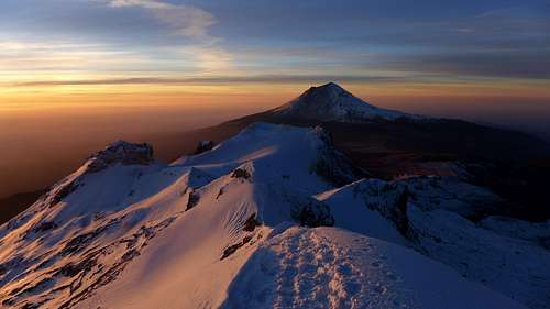
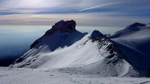
We were all excited to finally see the mountain up close. It certainly towers above Tlachichuca! We enjoyed the 2.5 hour 4x4 ride up to the Piedre Grande hut at 13860’.
![Orizaba view on drive]() Orizaba from just outside of Tlachichuca
Orizaba from just outside of Tlachichuca![Orizaba near hut]() Orizaba from near the Piedra Grande Hut.
Orizaba from near the Piedra Grande Hut.
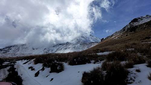
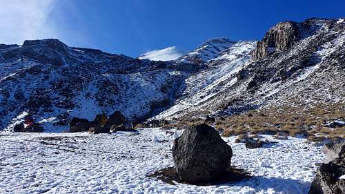
A recent storm from two days prior had cloaked the mountain nicely, and the snow line was near treeline. It was weird to see trees growing at 13K! We had received a report from a summit attempt that day that there was waist deep snow in the Labyrinth. I kind of found that hard to believe and I was glad we were going to see for ourselves! We brought tents in anticipation of the hut being too crowded during the holiday season, but there weren’t too many climbers in the hut when we arrived. We decided to risk it and stay in the hut.
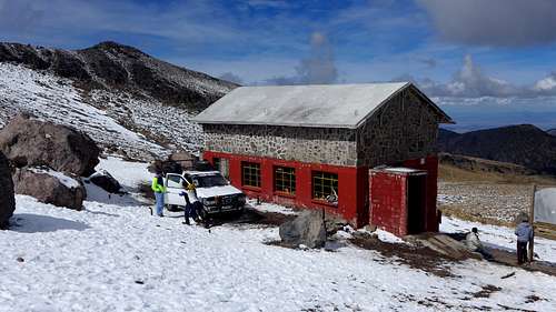
![Piedre Grande Hut-Orizaba]() Piedra Grande Hut, 13860 feet.
Piedra Grande Hut, 13860 feet.
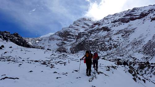
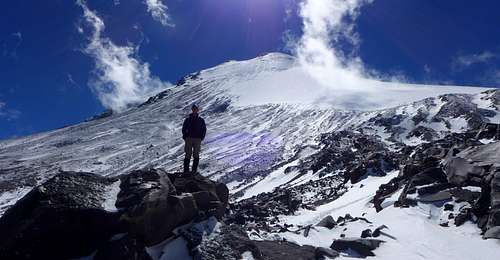
After a quick snack, we took off for a short hike with the goal being the base of the Labyrinth. Dave and Jane soon hit their altitude record once we passed the elevation of Mount Whitney. We went real slow and turned around where the route crosses over a rib to enter the Labyrinth at 15560’. It took us a leisurely 2 hours for this 1700’ stretch. We found the snow to be no more than ankle deep and the Labyrinth looked like it was in decent shape. Clouds were rolling in and out, but it was surprisingly very warm. I wish it was this warm in winter in Colorado! The views were superb.
![Orizaba from 15K]() Views on our first warmup hike.
Views on our first warmup hike.![Orizaba warmup hike]() Views on our first warmup hike.
Views on our first warmup hike.
The first night in the hut went pretty well as there were maybe 10 climbers there and I got some decent sleep. Dave, Jane, and I decided to take Diamox proactively, and I think it helped. I had a minor headache after the first hike that went away after hydrating more. The only side effect I noticed with Diamox is it makes you urinate more. Regarding food, I didn’t bring any freeze dried meals thinking I couldn’t get by customs, but two in our group were able to do so without any issues. The Canchola’s also provide you with gas canisters (white gas or Jetboil variety) and plenty of water. For a small fee, they will cook for you at the hut. The US dollar goes a long way in Mexico.
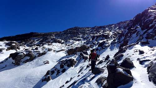
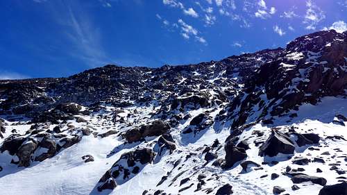
We picked up the pace a bit for our 2nd hike and we felt pretty good. A pair of German climbers were coming down as we were approaching the Labyrinth and said they got a bit off route in the dark, which made for slow going in the Labyrinth. There were multiple sets of tracks, but the snow was in good shape. I’m used to wallowing in sugar snow in winter! Mexico has more of a maritime snowpack that consolidates very quickly with the warmer temps. We felt comfortable going up with no axe or crampons as it was very easy to kick steps. I am sure conditions vary widely in the Labyrinth, but I felt like the routefinding was very straightforward with muchos cairns everywhere. It certainly was a lot more enjoyable with good snow compared to a scree slog. Our highpoint for the day was at 16200’, just a bit above the top of the Labyrinth. It took us 3 hours with a long break to reach the top of the Labyrinth.
![Orizaba approach]() Hike 2 views, the weather is better.
Hike 2 views, the weather is better.![Base of the Labyrinth on Orizaba]() Base of the Labyrinth
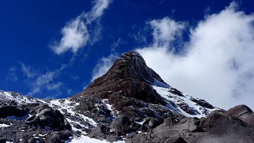
Base of the Labyrinth![The Sarcafago on Orizaba]() The Sarcafago towers above.
The Sarcafago towers above.![Orizaba from top of Labyrinth]() Orizaba and I at the top of the Labyrinth, 16200'.
Orizaba and I at the top of the Labyrinth, 16200'.
I predicted that we would see the rest of our team coming up from the hut for their acclimatization hike, and sure enough they were coming up and replicated our hike from day 1. We settled in early in anticipation of summit day, but the hut was buzzing with activity this night. There were probably 17-20 people in the hut this night, and it was quite loud . A Japanese climber woke up at midnight for his 1am departure and others followed in succession. I never officially fell asleep, so I was hoping this wasn’t going to affect me on the climb! I don’t think anybody on our team got more than 3 hours of sleep.
Pico de Orizaba (18406’)
December 26-28, 2014
6 miles RT, 4500’ gain
Via Jamapa Glacier/Ridge of Gold
Participants: Dave and Jane Schmid, Jessica Perez, Chris Doucet, Kimmy Kasubke, Taylor Holt, and Kevin Baker
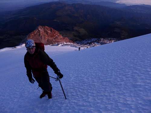
We decided to stagger the start times for our team so we would all be together through the Labyrinth. Dave, Jane, and I started at 2:25am and I think that was still a bit too early as we were still using headlamps on the glacier. If you think you will be moving well, I wouldn’t start earlier than 3am. It’s best to be out of the Labyrinth by noon on the descent as that is when the afternoon clouds typically show up. It was very warm with temps probably in the mid-30’s and not too much wind. I got by with glove liners for the first couple hours! I had heard of a lot of people having a hard time staying warm since you are moving at a slower pace compared to Colorado, but we really had nice weather throughout the trip. We made good time to the Labyrinth and we all regrouped here since the routefinding could be tricky in the dark. Jessica wasn’t feeling too good and wisely decided to turn around. She was able to join a couple who hired a guide and summited the next day.
There were multiple tracks in the Labyrinth that could be taken, and I didn’t follow the exact line we took the day before. We ended up taking more of a direct route towards the top and put in some new tracks. The snow was in great shape for kicking steps and it was fun routefinding in the dark. I thought the routefinding was pretty straightforward if you do it on a regular basis. We could see cairns very close by, so I don’t think we were really off route. We took a short break before reaching the top of the Labyrinth at 16K’ out of the wind and then found the trail in the dirt section before reaching the edge of the glacier. We made it to the base of the glacier at around 16700’ at 5:30am and put on crampons for the glacier climb ahead.
We had scoped out the glacier the day before from the Labyrinth and it looked like an ascending traverse right to the Ridge of Gold would be the least taxing route. The winds were very reasonable and the glacier was in great shape for very efficient crampon work. We all pretty much went at our own paces with Jane leading the way. Taylor stayed with me even though he could have smoked me with his long legs. We made great time up the glacier and I just set a pace that I could sustain without getting too gassed.
![Sunrise on Jamapa Glacier-Orizaba]() On Jamapa Glacier
On Jamapa Glacier![Taylor on Jamapa Glacier-Orizaba]() Taylor on Jamapa Glacier with the Sarcafago below.
Taylor on Jamapa Glacier with the Sarcafago below.![Slope angle-Jamapa Glacier]() Jamapa slope angle
Jamapa slope angle
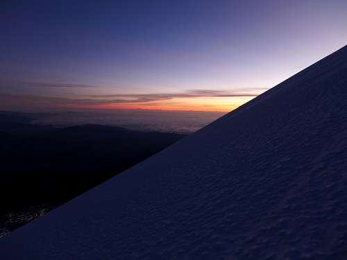
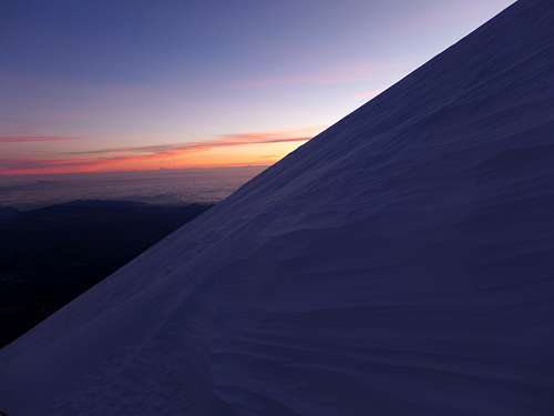
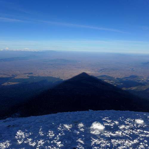
The slope angle is a fairly consistent 35-40 degrees and steepens before hitting the crater rim. We started cutting switchbacks near the top to keep the breathing under control and I was quite pleased to be feeling pretty good, although the last 500 vertical really lays the hammer down! The sun finally rose and gave us some pretty sweet views with the mighty shadow of Orizaba below us.
![Orizaba shadow]() Orizaba shadow
Orizaba shadow
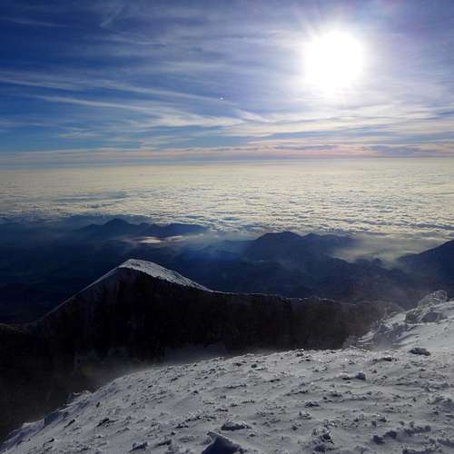
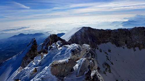
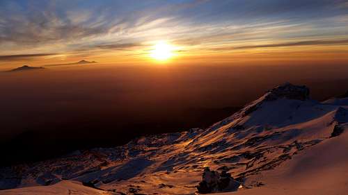
We finally hit the crater rim and the wind was a lot stiffer as we were mostly in a wind shadow coming up. Taylor and I topped out at around 7:40am with an inspiring view of the crater and the summit cross was cloaked in a ton of frost feathers!
![Orizaba summit views]() Summit views
Summit views
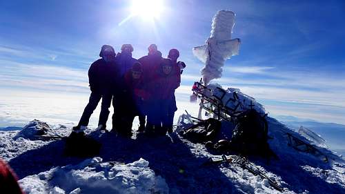
A Mexican climber was up there with Jane when we arrived and we quickly donned the puffy coats for a little summit party. The wind was probably gusting to 25 mph, but I don’t think it was any colder than the mid-20’s. If there was an 18er in Colorado, it would never get warmer than 0 degrees on the summit in winter!
![Orizaba summit]() Group summit shot
Group summit shot
I had read of groups bringing a rope for the glacier. I think this is overkill unless conditions change as we did not see any signs of crevasses. Even if the glacier was icy, it would be very tedious and time consuming to protect. Even though the snow was very firm throughout the day, it was textured enough that self arrest would be possible. There were a few who glissaded parts of the lower glacier, but it would be a rough ride and you may rip a whole in your pants! We had a very strong group and we made it to the top between 5 and 6.5 hours.
Summit Video
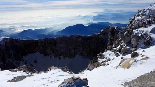
We made the assumption that we were the highest people in North America at the time as it was highly unlikely that anybody was this high on Denali or Logan this time of year. We headed back down after a little over an hour up there and decided to go for a more mellow descent. We went farther down the ridge from where we hit it towards Ice Needle. Jane and I ended up exploring the ridge a bit too far thinking the saddle would afford a very low angle line. It did, but the glacier was too icy at the saddle. We had to reclimb about 200 vertical with some scrambling, which isn’t easy at 18000’! We lost about one hour from this, but it did give us some pretty sweet views of the crater! The glacier was still very firm, but the plunge stepping down was easy as the snow was perfect for crampons.
![Orizaba crater rim]() Rim views
Rim views![Orizaba summit from rim]() Summit from rim
Summit from rim![Ice Needle-Orizaba crater rim]() Ice Needle
Ice Needle
We made it back down the Labyrinth and took yet another track down. We came across a family of 3 Mexicans at an optional 4th class step. After Jane and I downclimbed it, the older man couldn’t decide if he wanted to face in or out! Jane and I couldn’t figure out the Spanish word to say, so we just gave him the umpire home run signal to turn around. Nothing like working together with a language barrier!
![The Labyrinth-Orizaba]() The Labyrinth from base
The Labyrinth from base
The good thing about Orizaba unlike other big mountains is the descent is very quick. The trail had turned into a bobsled run near the hut as all the locals who go up a ways in tennis shoes had made it very slick! Jane and I got back to the hut at 12:30 for a 10 hour day. Dave can say that he smoked his wife down! Our ride down the mountain was on time and we were back at the Canchola’s in Tlachichuca after a long, dusty ride. We relaxed the rest of the afternoon and enjoyed a nice dinner at Canchola’s before embarking on our next adventure in the morning to Iztaccihuatl.
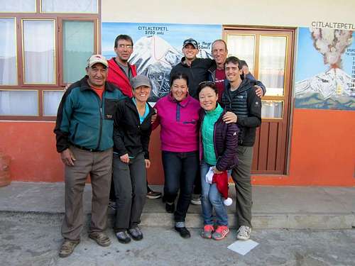
![Group shot at Conchola s-Tlachichuca]() Group shot at the Conchola's
Group shot at the Conchola'sIztaccihuatl
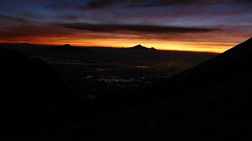
The logistics to climb Orizaba and Izta can be somewhat involved, so we decided to use the shuttle services of Antonio for the entire trip. We were down to a team of 4 as Chris and Kimmie went to a nice resort, while Jessica stayed on Orizaba. Antonio’s employee Joel picked us up right on time and we were off to the La Joya trailhead. We stopped at a Walmart to restock on snacks and I tried to experience the culture more by getting a few “drink” items. One “beverage” looked like some kind of green veggie drink. As I started drinking it in the front seat, Joel gave me a weird look and I said, “Mucho caliente, Senor!” Come to find out I was drinking a chip dip with picantes and jalapenos! I also purchased the Mexican version of eggnog and didn’t realize it needed to be mixed con leche! Joel mixed it with water for me and it tasted like coconut water!
Joel drove us up the paved road to the gate at Paso de Cortez, the saddle between Izta and Popo. Here we got our permits, but got the disappointing news that Joel couldn’t drive us to the La Joya trailhead because it was very busy with all the locals wanting to go up and see the snow and there is a limit on the number of cars they let pass through! I think there may have been some miscommunication, because we talked to a hiker later who was able to drive up. All of the sudden we had to figure out if we could still pull this climb off. Now we would have to hike 8 km up a dusty road just to get to the trailhead late in the afternoon with full packs for an early start in the morning! I figured we had paid to get here, so we might as well give our all and that we did.
![Popocatépetl from near La Joya]() Popocatepetl stands tall
Popocatepetl stands tall
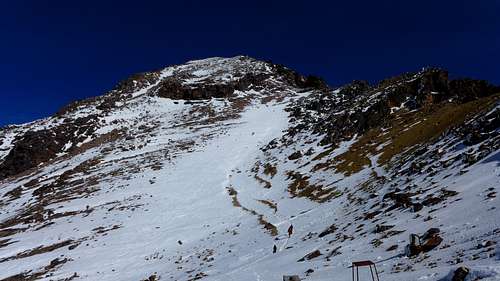
We had no maps other than a GPS track of the route itself. After about 1.5 miles and 300 vertical up the dusty road, a kind fellow hiker from Monterrey stopped to give us a ride! He and his two sons were also going to attempt a dayhike of Izta in the morning. We were so fortunate that they stopped, otherwise we would have only gotten a couple hours to rest before starting! Joel said we needed to be back at Paso de Cortez no later than 4pm, which was going to be rough since we guessed Izta could take up to 12 hours from the trailhead.
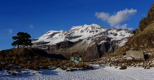
![Iztaccihuatl from La Joya]() Izta from the La Joya trailhead at 13000 feet.
Izta from the La Joya trailhead at 13000 feet.
Via La Arista del Sol
10 miles RT, 5100’ gain
December 30, 2014
On Christmas Eve, a storm dumped a lot of snow on Izta, more than there was on Orizaba. The snowline was at around 12500’, still accessible by car. Snow is a novelty to Mexicans, and with the holiday it was a cluster of activity up there! Our friend was kind enough to drive us all the way up to a spur trail only about 1.5 miles below La Joya at about 12800’. The locals are so enamored by the snow that they build a little snowman on the hood of their car and watch it melt as they drive down the mountain. We trudged up the steep, snowy trail and the locals looked at us like we were crazy going up with these huge packs! Loco Americanos, si, seniorita?
The trail somehow petered out after we topped out on a ridge and we had to posthole offtrail through some uneven tufts of grass and contour down to the road. We finally hit the real trailhead at 13000’ about an hour before sunset and were treated with a world class sunset as we were making dinner! I bought Jane’s 900 calorie Pad Thai meal from her, hoping that it would give me some extra energy for the long day ahead. Taylor and I shared my tent and we didn’t get settled down until about 8:30. I don’t think I got any real sleep, so I hope I could survive this long day at altitude! It was Jane’s first calendar winter camping, but it sure didn’t feel like Colorado winter camping.
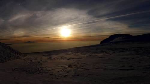
![Sunset from La Joya on Izta]() Sunset from La Joya
Sunset from La Joya![Camp views from La Joya TH on Izta]() Sunset from La Joya
Sunset from La Joya![Sunset from La Joya on Izta]() Sunset from La Joya
Sunset from La Joya
In order to allow ourselves enough time to get to the summit and all the way down to Paso de Cortez by 4pm, we started at 1:30am. We got up early enough to pack up camp and cached our camping gear since there would be a lot of people milling around while we were gone. By my calculations, we needed to summit in no more than 8 hours to get down on time. We knew there was a lot of snow on the mountain, so we hoped it was nice and firm all day. Dave set a nice steady, mellow pace out of the gate and it was very warm out, with temps in the upper 30’s. It was cool to see all of the city lights far below. After a gentle ascending traverse, the trail climbs steeply to about 14040’ to a saddle, the first portillo. The trail then descended briefly on the other side of the ridge and we then climbed steeply up to another saddle at 14430’.
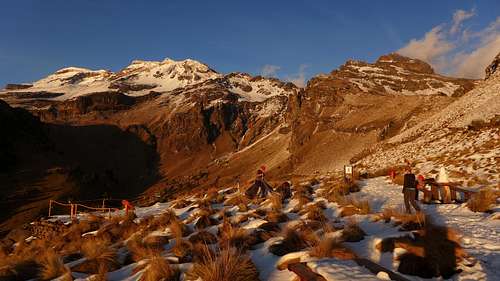
We were making good time, but the wind started to pick up. It was surreal climbing such a big mountain in the dark and it was hard to tell how bad the runout was below! At the 2nd portillo, the trail crossed back over to the left (west) side of the ridge. The snow was very firm, but there was a nice track cutting across the slope. After a couple minutes across, Dave got out his axe and I suggested that we all go back to the little saddle and put on our crampons. We couldn’t see the runout, but you would only have a few seconds to self arrest on this firm snow. It turned out to be a good call as it felt a lot more secure with crampons, even though the terrain was easy. It was a long traverse on both sides of the ridge. The route passes through the saddle between the feet and the knees, before finally reaching the Grupo de los Cien hut at 15500’. We made it to the hut in 3 hours, which was good considering we had a couple breaks and had to mess with crampons already.
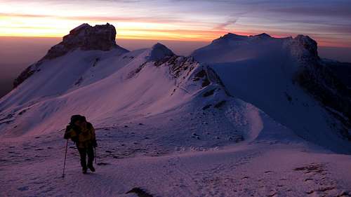
The climb to the knees summit is really demoralizing in the dark because you have no sense of reference as to when this slope is going to let up! We climbed about a 35 degree snow slope to the left of the ridge crest to the famous cross, then had a brief stretch of some class 3 scrambling. When we reached the summit of the Knees, we could feel the wind a lot more. Luckily, it was still pretty warm for such a high altitude even though the wind was blowing 30mph at times. There was a brief downclimb below the summit of the Knees that was trivial on the return but got your attention in the dark with the wind blowing in your face. The rest of the traverse to the summit involves another 3 false summits, but isn’t very sustained.
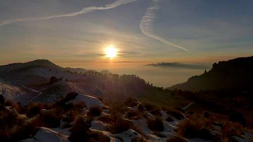
We made good time in the mellower areas as our acclimatization was really starting to pay off. The sun finally rose and I must say it was one of the best I have ever seen. All the smog in the valley is very bad, it makes for some great color contrasts for the sunrise! This was literally one of the most scenic climbs I have been on, and I have been to a lot of cool places in Colorado!
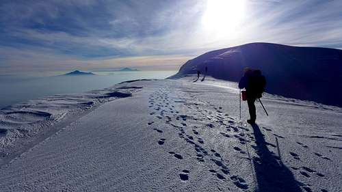
![Silhouette on Orizaba on La Melinche on Izta]() Sunrise views on Izta
Sunrise views on Izta![Nearing sunrise on Izta]() Sunrise views on Izta
Sunrise views on Izta![Amazing sunrise on Izta]() Sunrise views on Izta
Sunrise views on Izta![Izta s southern summits and Popo]() Sunrise views on Izta
Sunrise views on Izta![Amazing views near Izta summit]() Sunrise views on Izta
Sunrise views on Izta
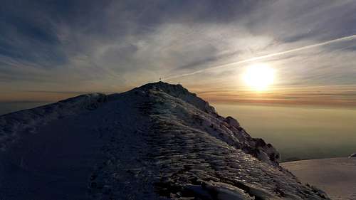
We were all excited that it looked like we were going to have plenty of time to summit. I think the final two false summits were cooler than the true summit. There was a cool fin of snow that we crossed after the final false summit and we finally topped out at last on the 7th highest free standing mountain in North America at 7:32am for a 6 hour ascent.
![Nearing summit of Iztaccihuatl]() Nearing the summit
Nearing the summit
We stayed on the summit long enough to take a few photos, then took a break out of the wind on the edge of the glacier plateau. The bad thing about this hike is you are up high for a long time and you have about 1200’ vertical on the return. Perhaps half of the hike is above 16K, so I thought it was a bit more strenuous than Orizaba! I just kept pounding the snacks and water and felt pretty good on the descent. The views on the way back were superb. It was cool to finally see what we climbed since about five hours of the ascent was in the dark!
![Ridge run on Izta]() Return ridge run
Return ridge run![Izta ridge run]() Return ridge run
Return ridge run![Snow climb on the Knees-Izta]() Snow climb of the Knees summit
Snow climb of the Knees summit
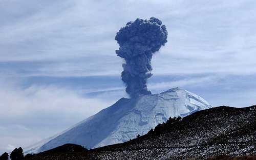
There were only 3 people that we passed on the way to the top, but there were some people strung out on the ridge beyond the hut. Most of them had not reached the Knees on our return, so we figured only a solo Mexican climber and another group of 3 were far enough along to make it. One of the guys had a deflated look when I told him he had dos horas left! We finally were able to take our crampons off after the long traverse and the lower trail had turn into a mud bog in spots and slick slush near the bottom as there were many locals coming up in tennis shoes. On the return down the ridge, we were treated with a minor eruption on nearby Popocatepetl! It is a regular occurrence. The last 200 feet to the trailhead may have been the crux of the climb! We arrived back at camp at 12:15pm and we got our stuff packed up in short order.
I didn’t have high hopes that we would find somebody to give us a ride down. The father and his boys had turned around below the summit of the Knees on our descent and were a few hours behind us, so we just started marching down the road and hoped somebody felt sorry for us. We were once again treated to another eruption over on Popo, and this time the ash cloud was very high!
![Popo blows!]() Popo speaks!
Popo speaks!
I think it is currently more active than usual because it made the news. The 5 mile walk down the road was a cluster of activity. First we trudged through slush, then mud, then all the dust from the traffic. At one point the road was so jammed that we had to wait to walk through the traffic! We got back to Paso de Cortez at 3pm with an hour to spare, and Joel was waiting for us with awesome tacos, a Coke, and water! The final mile was brutal in mountaineering boots, but the view over to Popo made up for it.
Joel got us back to Mexico City where we stayed at a nice Doubletree hotel near the airport and had a nice celebration dinner that night. This is a trip that I will never forget, and I am sure my partners would agree. The trip to Mexico made me feel blessed for the modern conveniences we enjoy in the US, but the people down there cherish their families, and that is something that I admired. I would highly recommend the Canchola’s family in Tlachichuca (www.summitorizaba.com) as their services are very affordable and convenient. Antonio is also an excellent choice for shuttle services if you are going with a good sized group. The logistical conveniences were well worth the extra money. If you are looking for a taste of international mountaineering where you can day hike to high elevations, then Orizaba and Izta make for a great introductory trip!


Comments
Post a Comment