
-
 10977 Hits
-
 94.02% Score
-
 45 Votes
|
|
Mountain/Rock |
|---|---|
|
|
46.42165°N / 13.54503°E |
|
|
Trad Climbing, Scrambling |
|
|
Spring, Summer, Fall, Winter |
|
|
6585 ft / 2007 m |
|
|
Overview

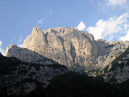
SW face
Cima delle Cenge is the first 2000er in the northern range of Riobianco mountains. In fact, it is the only rock peak visible from the road in the Rio del Lago valley. Cima delle Cenge has a form of elongated ridge, with a short vertical S wall, falling down from the summit crest. The N wall emerging from the Val di Riofreddo valley is much higher, but wildly rugged and partially covered with grass and dwarf pine bushes. Therefore, it is incomparable to the S wall, built of compact, for the Julians extraordinary unusual dolomite limestone.
Cima delle Cenge is situated east of the nearby Vetta Bella/Lepa glava, 2049 m, and separated by the Forcella delle Cenge, 1820 m, from Vette Scabre, 1860 m, an impervious rocky area, overgrown with exuberant vegetation. Two prominent elevations in the massif of the Cima delle Cenge merit to be mentioned: Torre, a slender pinnacle west from the main summit and Torre Irma, a narrow spine in the north ridge of the mountain.
The first documented ascent was performed by A. Gstirner, accompanied by local hunter Miller from Cave del Predil (22. October 1893).
There are no secured paths to reach the summit of this interesting mountain. The normal ascent route, which is not exceedingly demanding (easy scrambling, UIAA II/I) is only marked by red dots.
 |
Getting There
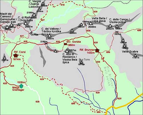
Riobianco and its mountains
For general orientation see the Julian Alps group and the Vis and Montaz subgroup page.
The starting point for the normal ascent route is an old mining village Cave del Predil/Rabelj (once rich mines of lead and zinc are not operational today, so the place is almost a ghost-town), 12 km from Tarvisio/Trbiž. To climb the S wall, we have to ride forward about 5 km in the direction of Sella Nevea pass, reaching the bridge over the Riobianco creek, where the marked path to the Rif. Brunner hut begins.
Mounaineering Map:
Alpi Giulie Occidentali Tarvisiano. Tabacco 019, 1: 25 000.
Red Tape
No limitations.
Huts, Bivouacs, Camping
1. Rif. Brunner hut, 1432 m. Picturesque old hunting hut of the King Frederick of Saxony should be the best starting place, but it seems to be destined to destruction (we hope it wouldn't happen) and so barely usable for lodging.


2. Bivouacs Gorizia, 1950 m are much more comfortable and perfectly clean, but placed somewhat too high for the routes in the S wall of Cima delle Cenge. To reach the wall, we have to descend 500 altitude meters, only then we can start the approach ascension.
3. Numerous alpinists spend the night in their vehicles on the parking place near the bridge over the Riobianco creek.
Routes Overview
The SW wall
1. Normal ascent route, E ridge. Difficulty UIAA II/I. First ascent: probably in ancient times by local shepherds and chamois hunters. The marked and well-trodden path (No. 656) from Cave del Predil to Forcella delle Cenge is an easy walking-up, 2.30 h (here is a description in Italian language). Another approach to the col is possible from the Brunner hut, also. The track is well marked and somewhere secured by iron ropes, but it is so steep and rugged, that could be hardly recommended. From the col we reach the summit in 45 min by easy scrambling through a steep gully then along the panoramic E ridge.
2. SW Gully, S wall. Difficulty: UIAA III/II, 150 m, 1 h 30 min. First ascent: H. Klug, G. Renker 1916. Despite the excellent rock, this route is rarely climbed today.
3. C. Carratu, A. Perissutti Route, SW Wall of the Torre. Difficulty: UIAA V/IV, 100 m, 2 h. Short, but strained climbing.
4. Via direttissima. S wall. Difficulty V/IV, 200 m, 2-3 h. First ascent: unknown (!?). One of the finest routes in this range of difficulty in the Julians. Sheer poesy of climbing in the black, vertical chimney/dihedral, cutting the wall in the middle. Rock quality is superb.
5. Right direttissima, S wall. Difficulty: UIAA IV+, 200 m, 2-3 h. First ascent: T. Mihelič, J. Rupar, 1975. This route goes some 25 m right from the old direttissima. Although resembling the former in character, it doesn't reach its climbing beauty. (That was frankly uttered personally by my good, regrettably late friend Tine Mihelič).
When to Climb
Due to low altitude, favourable position towards the south and very steepness, respectively, the S wall is climbable practically all the year in snowless conditions.
Miscellaneous Info
If you have information about this mountain that doesn't pertain to any of the other sections, please add it here.