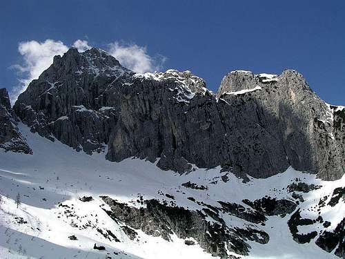
Cima di Riofreddo / Divja Koza, seen from the East
The narrow group of Viš massif has towards the East four high summits, which were in 19th century by locals all called Gamsja Mati / Gamsmutter / Madre dei Camosci. It was the great pioneer of Julian Alps, Julius Kugy, who gave them distinct names. So, the easternmost summit of this small group got a name: Divja Koza / Kaltwasser Gamsmutter / Cima di Riofreddo. Cima di Riofreddo is a wonderful summit, a mighty fortress, sending high walls and sharp ridges on all sides. It is the easternmost cornerstone of the whole narrow Viš group. Its most prominent side is of course its northern wall. More than 700 m of vertical rocks hosts several beautiful classical climbs and is in the whole monumental set of walls above Rifugio Pellarini the most often climbed. Also the Eastern wall, rising above the end part of Riofreddo valley, is very monumental and attractive for climbing. The southern face and the ridge towards the Western neighbours are less steep, but still rocky and rugged, offering one easy ascent to the summit only. These some 500 m high rocky slopes are on the upper part cut by horizontal ledges, which are used for a beautiful ferrata, named Anita Goitan, which now brings the summit of Cima di Riofreddo closer to a common mountaineer. But we shall return to these famous ledges later.
Cima di Riofreddo from the summit of Vis
Cima di Riofreddo (the leftmost summit) from the N
South-East of the main summit the rocks of Cima di Riofreddo lower down to a narrow notch, which means the highest point of the beautiful Riofreddo valley. This is Forcella di Riofreddo / Trbiska škrbinica, 2240 m, where the narrow Viš group ends and the beautiful ridge of Cima del Vallone / Trbiška Krniška špica, 2368 m, begins. This notch is an important passage and can be reached by marked and not marked paths from several sides. In good conditions it is also one of the finest goals for tour skiing in the whole Viš group. On the summit of Cima di Riofreddo another wild crest branches from the main one. This is the Vergini/Device and Rondini/Lastavice ridge - not high, but very wild summits, running in the NE and N direction. Finally the western ridge attaches Cima di Riofreddo with Innominata and the other summits of Viš group.
The ascent of Cima di Riofreddo is by no means easy. No marked path reaches its summit, but the ferrata Anita Goitan comes close. From it you still need to climb some good 100 m, difficulties are in the range of UIAA -II. Cima di Riofreddo was first ascended by J. Kugy, R. Baumgartner and their guide A. Komac in 1885.
The Ledges of Gods
On the Ledges of Gods
Ferrata Anita Goitan
On the mountains of Viš group vertical lines are predominating. But still, as on so many places in Julian Alps long and interconnected systems of ledges can be found, enabling fine passages, where otherwise only a hard climbing would do. It was Julius Kugy again, who explored these systems thoroughly. Being used that mountains reveal the highest secrets to their lovers, he was still highly surprised, discovering, that such a system of ledges runs almost around the whole higher part of Viš peak. Only one part of the ring was broken, but also there Slovenian climbers later forced the passage. And not only that. Kugy discovered, that the broadest ledge persistently continues also over the slopes of Madre dei Camosci / Gamsja Mati / Gamsmutter, further over the slopes of Turn/Torre and Innominata and finaly over the northern and eastern face of Cima di Riofreddo. On Forcella di Riofreddo of course the ledge, where nowadays Anita Goitan ferrata goes, cuts horizontally the whole southern face of Cima di Riofreddo. This is one of the greatest wonders of Julian Alps. Kugy, being also a lyrical person, imagined, how on such ledges, covered with a fine white sand gods themselves are walking, hands in pockets, discussing important themes, while all around them there are only vertical abysses. That's why he named the whole system The Ledges of Gods. Some marked routes (ferratas) nowadays use these ledges, while a great portion of them is still left unchanged. Let it be so!
For the normal (southern) ascent we start in Val Rio del Lago / Jezerska dolina, and reach either Rif. Corsi, 1874 m (three ascent paths) or Rif. Brunner, 1432 m, in Rio Bianco / Beli potok valley.
Valle di Riofreddo
Much longer is the approach through the beautiful Valle di Riofreddo / Dolina Mrzle vode. The road in it deters in Val Rio del Lago by the Riofreddo village, 833 m, but is closed for public traffic from the very beginning. Through the valley to Forcella di Riofreddo, 2240 m, you will need some 4 hours, and almost two more to the top.
All northern ascents start in Valbruna/Saisera, at Rif. Pellarini, 1499 m. From the Tarvisio-Udine highway you exit near Ugovizza/Ukve, drive a bit towards Tarvisio and then turn southwards into the valley.
Climbs in Cima di Riofreddo
Ferrata Anita Goitan
This ferrata is part of the whole ferratas system, traversing Viš and Montaž group. On the eastern part it starts on Forcella di Riofreddo / Trbiška škrbinica, 2240 m, which can be reached from various sides (Rif. Corsi, Rif. Pellarini, Riofreddo valley, Rif. Brunner). Then it runs over the southern slopes of Cima di Riofreddo, around Innominata tower, over the southern slopes of Turn and Madre dei Camosci, over the southern slopes of Iof Fuart / Viš, to Moses notch, over the southern slopes of Cime Castrein / Koštrunove špice on Forcella Lavinal d'Orso / Škrbina Sprednje Špranje, 2271 m. From there on ferrata Ceria Merlone continues towards the west. The whole ferrata Anita Goitan is considered as medium hard, with many very exposed passages and very long to be done in one day (some 11 hours).
Normal approaches on Cima di Riofreddo
<-- Cima di Riofreddo / Divja Koza
and its marked routes
Route 1: Rif. Corsi, 1874 m - Forcella di Riofreddo - Ferrata Anita Goitan - South face ravines - Cima di Riofreddo.
Route 2: Riobianco, 833 m - Forcella di Riofreddo - Ferrata Anita Goitan - South face ravines - Cima di Riofreddo.
Route 3: Rif. Pellarini, 1499 m - Sella Carnizza - Forcella di Riofreddo - Ferrata Anita Goitan - South face ravines - Cima di Riofreddo.
Route 4: Rif. Brunner, 1432 m - Forcella del Vallone - Forcella di Riofreddo - Ferrata Anita Goitan - South face ravines - Cima di Riofreddo.
Route 5: You can come by Ferrata Anita Goitan also from the West, for example from the summit of Viš.
Tour Skiing
Forcella di Riofreddo
Riofreddo valley: Riofreddo, 833 m - Forcella di Riofreddo, 2240 m. Steep and very narrow couloir just below the notch (50 m).
Alpinistic skiing
Forcella delle Vergini from the North. A 250 m high couloir, lower part wide enough and to 40 degrees steep, upper part narrow and much steeper. Some 60 m below the notch the couloir branches, the left branch can be skied, but is only some 2 m wide and up to 55 degrees steep.
Climbing
Cime Vergini
S face normal ascent (from Anita Goitan), 320 m, II-.
N-NW face: Krobath-Metzger route, +IV,V, 700 m (550 m to the Ledges of Gods). 1933. Very beautiful, a real dolomite climbing joy.
N face: Comici-Fabjan route, +IV,V, one detail +V, 760 m (550 m to the Ledges of Gods). 1928. Demanding, wild ambient, dry rock required.
Piussi variant, 1958. Harder than the original Comici-Fabjan (hardest detail -VI).
Spigolo NE (Comici-Fabjan). III-IV, one detail -V, 750 m (600 m to the Ledges of Gods). 1929. Beautiful classic in a good rock.
East face: Zuani route, III/IV, 950 m.
East face: Veronica Buonarota or Bauer route, III,IV, 550 m (400 m to the Ledges of Gods). 1932.
East face: Agnolin Carratu route, III,IV, one detail +V, 350 m (to the Ledges of Gods). 1971. Nice, natural route.
East face: Kugy route (Kugy, Poech, Ojcinger, Pesamosca), II,III, 380 m (230 m to the Ledges of Gods). 1913.
SE ridge, II-III, 330 m.
On the web there's a short guidebook in Slovenian language, with some rough topos here.
Descents. You do routes #2 to #8 from Rif. Pellarini, so you need to return on the northern side of the mountain. You descend by the normal route southwards, follow the Anita Goitan ferrata to Forcella di Riofreddo descend in the upper part of the valley and the over Sella Carnizza / Žabniska škrbina, 1767 m, down to Rif. Pellarini. If you conclude any of the climbs on the Ledges of Gods, you can follow them towards the right (westwards) and descend by the NE ravine of Viš (Golla NE). It is possible also to follow the Ledges of Gods towards the left (eastwards). First they are comfortable, when they get lost you ascend up by ravines some 60 m and cross further to the left on the southern side, soon reaching Forcella di Riofreddo.
Red Tape
No limitations.
When To Climb?
April on Forcella di Riofreddo
Summer and autumn months are the best. In these areas the weather is most stable from July till October. A winter ascent from S requires full winter equipment and must be hard enough.
Huts And Camping
In Julian Alps, camping is officially not allowed, or may be only on high regions in emergency. The area is good covered with mountain huts wich offer you all the comfort needed for a reasonable price, and in winter the majority of them also have permanently opened winter rooms.
Rif. Guido Brunner, 1380 m. In Val Riobianco. From the main road in Val Rio del Lago 1 h 15 min.
Bivacco Gorizia, 1950 m. In Val Riobianco. From the main road in Val Rio del Lago 3 h.
Rif. G. Corsi, 1874 m, 0428.2013, 040.390025, 0428-68113. South of Iof Fuart. From Sella Nevea pass or from the main road in Val Rio del Lago 3 h.
Rif. Divisione Julia - Nevea, 1142 m. Accessible by car.
Rif. Pellarini, 1499 m, 0428-60135. From Saissera 2h.
Children refers to the set of objects that logically fall under a given object. For example, the
Aconcagua mountain page is a child of the 'Aconcagua Group' and the 'Seven Summits.' The
Aconcagua mountain itself has many routes, photos, and trip reports as children.
Parents refers to a larger category under which an object falls. For example, theAconcagua mountain page has the 'Aconcagua Group' and the 'Seven Summits' asparents and is a parent itself to many routes, photos, and Trip Reports.

 13747 Hits
 86.37% Score
 22 Votes
 Cima di Riofreddo / Divja Koza, seen from the East
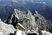 Cima di Riofreddo from the summit of Vis
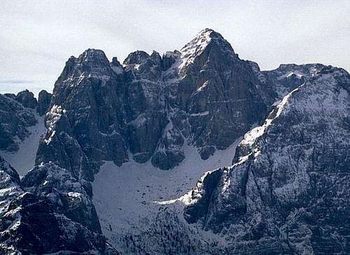 Cima di Riofreddo (the leftmost summit) from the N
 On the Ledges of Gods
 Ferrata Anita Goitan
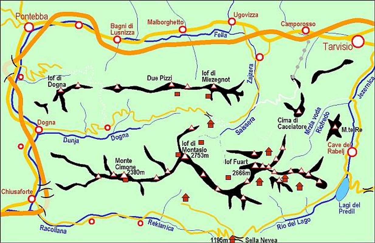
 Valle di Riofreddo
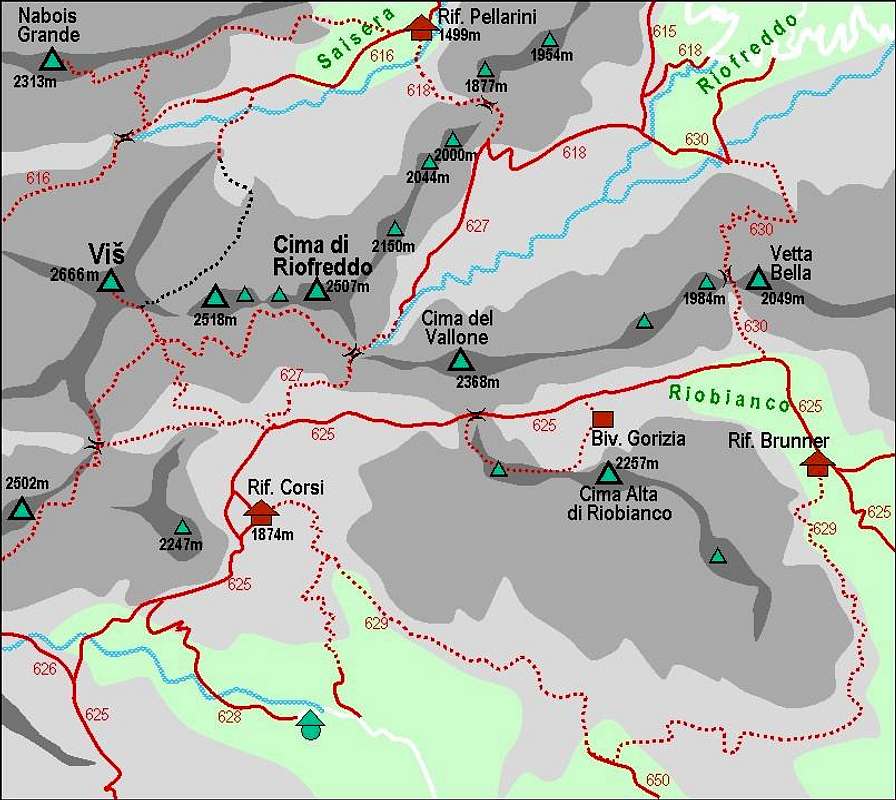


 April on Forcella di Riofreddo