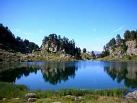
Circ de Colomers Overview
This highly scenic amphitheatre-shaped valley is located high in the southern slope of
Val d’Aran, in the
Pyrenees range. It was the head of ancient glaciers that excavated it on granitic terrains. Those disapeared glaciers were tributary of a principal one that ran down slope to the northern side of the
Pyrenees along the
Aran Valley. The word Circ in its name refers precisely to its glacial origin, as in catalan language “circ glaciar” means glacial head.
Circ de Còlomers is the upper part of
Arriu d’Aiguamoïx valley, which meets
Val d’Aran in
Salardú. Strictly speaking the Circ starts in the slopes that give access to
Plans dera Lossa from
Pletiu dera Montanheta. Below this level, alluvial morphology superimposed to shapes of glacial origin is dominant. Here water currents run slowly and sneak through meadowy alluvial plains crossing dense conifer forests.
Above
Plans dera Lossa,
Circ de Còlomers is full of evidentia of its glacial origin. From its more than 40 glacial lakes and ponds of all sizes, to the step-sided ridges, horns and peaks that close it by west, south and east sides, either the terrain is made up of non-sorted till deposits -with big erratic blocks-, or it is made up of sheep-back rock surfaces, often sowing glacial polishing and striation.
Tossau deths Ossos, the rounded northwards prolongation of the ridge that joints downwards
Gran Tuc de Còlomers and
Tuc deth Pòdo, divides the Circ into two smaller valleys at its occidental and oriental sides.
The occidental valley is closed at west by the ridges and peaks that limit it with circ del
Montardo (
Tuc de Cap de Port and
Agulles de Travessany) and at south by those limiting it with the circ d’
Aigüestortes (ridge
Gran Tuc de Còlomers –
Creu de Còlomers). Its main lakes are
Estanh Mort,
Garguilhs de Sus,
Estanhets de Port and
Lac deth Port de Colomers.
The oriental valley is closed at east by
Pic Gran de Sendrosa, that limit it with
Circ de Saboredo, and at south by
Tuc de Bergús and
Tuc de Ratera, limiting with the circ d’
Aigüestortes. The main lakes here are
Lac Long,
Lac Redon,
Lac Obago,
Lac de Pòdo,
Lac deth Cap de Colomers and
Estanh de Ratera de Colomers.
Because of its nataural, scenic and biological interest this area is protected and included into the
Parc Nacional d'Aigües Tortes i Estany de Sant Maurici.
![]()
Cows near Lac Obago |
| ![]()
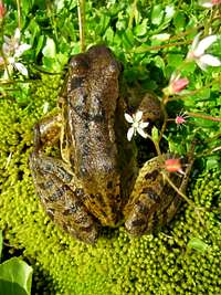
A frog in Estanhets deth Pòrt |
| ![]()
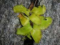
Pinguicula Nevadensis near Lac Redon |
|
Route Overview
The route described here is a circular trail that starts and finishes at
Refugi de Colomers hut. Walking it gives quite a comprehensive insight into the
Circ de Colomers geography -distribution of its lakes, peaks and ridges-, as well as on other aspects of its natural history. I will describe the route under summer conditions, but in
Refugi de Còlomers, you can always get information to go round the trail on other seasons. There you will find this route referred to as “
Circuit Llarg de Còlomers”. Another much frequented –and easier- route is “
Circuit Curt de Còlomers” or “
Circuit dels Llacs de Colomers” (Short Còlomers Circuit or Còlomers Lakes Circuit), it just shortcuts the longer route at lower heights. Although I will not describe here the shorter route, I introduce it because it is worth to know that while the long one is signaled by red painting markings, yellow paintings are used for the second, so take care to follow just the red ones, unless you are interested in the shorter hike.
The total estimated timing is of about 4 hours, covering a difference of level of around 600 m. With some additional effort, it is possible to walk it all starting and returning to the parking at
Banhs de Tredòs trailhead. In that case, about 7 hours would be required and the difference of level would be of about 800 m.
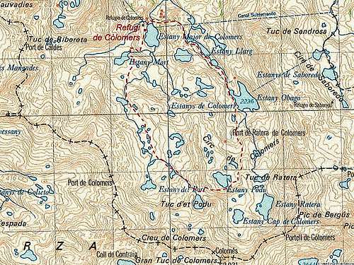
![]()
Sketch of the circular route (marked in red) |
Getting There
Go to
Salardú, in
Val d'Aran, and from there take the road that goes to
Banhs de Tredòs via
Vall d'Aiguamoïx. In summer –the season for which this route description is suited -, between 1st of July to the September 30th, the car has to be left in the parking area of
Banhs de Tredòs. From there to the hut, there is a hike of about 2 hours. There is also the alternative of using a Taxi service that, by following a forestall track, will approach you much closer to the hut. Out of this period, you are allowed to approach you car until
Pletiu dera Montanheta. See
Refugi de Colomers Hut for a descrption of the approaching route.
Huts
![]()
Refugi de Colomers hut |
hut is located at route start, where last minute additional and seasonal information about this route can be obtained.
Route Description
I will describe this circular route in the counterclockwise sense of progression. The starting point is
Refugi de Colomers hut, located some meters over
Lac major de Colomers. The mountains that can be seen above it are
Tuc Serreta,
Pic de la Tallada Llarga and
Agulha Gran de Colomers. Start walking along the path signaled with read painting, leave the lake shore at left hand. As this stretch of the path is shared by both this and the shorter route, you will find here red and yellow paintings. Not far away you will start ascending a slope that gets you to
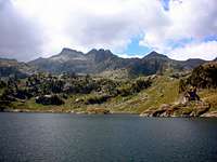
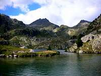
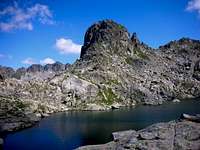
Estanh Mort, a nice lake from where you can see
Tuc deth Port and
Tuc de la Ribereta peaks in front, as well as
Tuc Serreta and
Tuc de la Tallada Llarga at left.
![]()
Lac major de Còlomers |
| ![]()
Estanh Mòrt, with Tuc deth Pòrt above it |
| ![]()
Tuc Serreta from Estanh Mòrt |
|
Move to the left leaving
Estanh Mort shore at right hand and follow the path making its way across meadows and minor water ponds and lakes. Some time after you will see that the yellow signals detach to the left from the red ones we are following. They mark the shortcut to the lakes route. Latter on we reach
Garguilhs de Sus lake, a very picturesque one, surrounded by steep slopes at the foot of
Tuc Serreta,
Tuc de la Tallada Llarga and
Agulha Gran de Colomers peaks.
![]()
Agulha Gran de Colomers from Garguilhs de Sus water pond |
| ![]()
Garguilhs de Sus water pond |
| ![]()
From Garguilhs de Sus to Estanhets deth Pòrt |
|
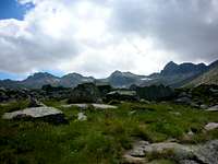
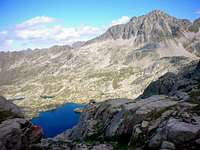
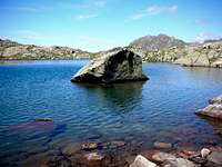
As you proceed you reach a much wider and flatter zone, splashed here and there by lakes and ponds of different sizes and shapes. These are
Estanhets deth Port. The terrain is meadowy yet, but more and more rockier as we proceed. The ridge that joints
Gran Tuc de Colomers to
Creu de Colomers through
Pic Blanc and
Pic Oriental closes the view in front of us.
![]()
The Còlomers ridge from near Estanhets deth Pòrt |
| ![]()
Estanhets deth Pòrt |
| ![]()
Pic Oriental and Creu de Còlomers |
|
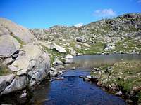
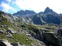
As we continue we reach
Estanh deth Port de Colomers -at the foot of
Creu de Colomers peak-, while
Port de Colomers, the saddle that passes to
Circ Obago and
Circ del Montardo, can be seen at right. At this point, the path starts to climb across rocky terrain to gain
Coreth deth Pòdo, a saddle between
Tuc de Pòdo peak and the lower
Tossau des Ossos. This saddle is more or less at the same height of a nice lake named
Estanh Gelat, which has great sights to
Gran Tuc de Colomers and
Pic Blanc. With a height of about 2590 m., this is the highest point of this route.
Coreth deth Pòdo separates the stretch of the route that ascents along the occidental valley, from the one that will descend along the oriental one (with respect to
Tossau des Ossos ridge axis). Heading to the oriental valley we see below
Lac de Pòdo, among smaller ones, and
Tuc de Ratera besides, closing the scene.
![]()
Estanhets deth Pòrt |
| ![]()
Tuc de Pòdo and Estanh Gelat |
| ![]()
Tuc de Ratera and Lac Pòdo from Coreth deth Pòdo |
|
The descent path, though clear and well indicated, makes its way across big blocks, boulders and scree, softening when it reaches
Lac de Pòdo. Advance leaving the lakeshore at left hand. The path continues making its way across more lakes and ponds. Looking back and upwards, we see
Gran Tuc de Colomers summital zone and the
Tuc de Pòdo pyramid.
Tuc de Ratera is behind us and
Gran Pic de Sendrosa can be seen far away closing the valley at right.
![]()
Lac de Pòdo |
| ![]()
Summital ridges of Gran Tuc de Còlomers and Tuc de Pòdo |
| ![]()
Tuc de Ratera |
|
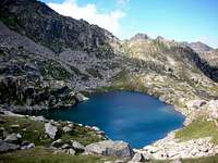
After having descended a level of about 200 m. from
Lac de Pòdo, we reach
Lac Obago, the biggest one in the
Circ and very scenic.
Lac Obago is followed by
Lac Redon and then by
Lac Long. After that the path surmounts a small slope an reaches a saddle named
Coret deth Clòto, from where
Lac Major de Colomers can be seen again and with it, the
Refugi de Colomers hut, starting and ending point of this circular route.
![]()
Small lake over Lac Obago |
| ![]()
Lac Obago, with Tuc de Ratera over it |
| ![]()
Lac Redon |
|
When to go
This route description applies mostly to summer conditions, but the route can be done all the year.
Essential Gear
Compass and map and, if you plan to go in winter, crampons and ice axe, or snowshoes or skies are required, but in that case gather additional information at
Refugi de Colomers hut, or at its web site.
Cartography
 | Val d'Aran
Hiking map and guide with activities and data of interest.
Scale: 1:40.000
UTM grid of 1 km. divisions
GPS compatible
Marked trails
PVP: 11,00 €
Available in catalan, spanish and frech languages.
Editorial Alpina
|


visentin - Apr 22, 2010 6:44 am - Voted 10/10
etymologyDo you have any idea what is the meaning of the word Còlomers or what does this word mean ? I have been searching a bit but in vain.
PereRamon - Apr 22, 2010 2:37 pm - Hasn't voted
Re: etymologyHi Eric, if the word is catalan in origin (it could be as in the area both catalan and aranes languages are used) colomer could be easily interpreted as pigeon loft or pigeon house, and colomers is just its plural form, so Circ de Colomers could mean pigeon houses circus. Strange, but place names are almost always enigmatic. In case it were not catalan but aranes I wouldn't know... I manage myself in catalan, but not in aranes, although it is quite interesting!... Many thanks for your kind comments!
visentin - Apr 23, 2010 3:34 am - Voted 10/10
Re: etymologyThanks for this interesting explanation. There is also a Refugi Colomina not far around here, perhaps the same origin ? One possible explanation is that the "pigeons" (or colombes, "doves" in english) designate indeed the Lagopedes (alpine ptarmigans who live the the Pyrenees) and maybe Colomers used to be a place where people saw a lot. Do you think this could be plausible ?
PereRamon - Apr 23, 2010 8:05 pm - Hasn't voted
Re: etymologyIt sounds strange for me that people confussed that bird with doves, but well, it is possible. In Catalonia the root colom is very common in many places and in many contexts, not just in the Pyrenees, but all over the country. As a surname, for instance, there is the outstanding case of Cristopher Columbus, that signed always as Colom (and this is because he was catalan, obviously!). Being colom such a widespread root, I guess that it was at least clear for people what a dove was and what was not, so I see unlikely confussion with lagopedes. Colomina is just a diminutive of Coloma, and that is the femenine of Colom, used often as a women's name. Nevertheless it can also be interpreted as a little female dove... who knows? but is always interesting! Regards Eric!
visentin - Apr 26, 2010 2:17 am - Voted 10/10
Re: etymologywell it's just a supposition !
PereRamon - Apr 26, 2010 5:49 am - Hasn't voted
Re: etymologyOf course I know, no knowledge can be gathered without making suppositions and hypothesis... thanks for all Eric, have a good day!