
|
|
Route |
|---|---|
|
|
31.17499°N / 7.82561°W |
|
|
Hike |
|
|
A few days |
|
|
PD |
|
|
Approach
start of the TREK from l'oukameiden : see 'getting there' on oukameiden mountain
 |
Route Description
Day 1 :
from l'oukameiden (2500 m) to the village of tacheddirt at 2300 m, the highest village of the High Atlas. 3 hours
Go in direction of the ski station lift. Reaching the lift, follow the pist which is oriented E, then you will reach small hut in the valey, from there take the S direction to the tizi n oueddi pass (2960 m), and from there descend the pist on your left hand which is going through rocks area.
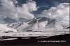
During all the Hike, the Angour will be on your left hand, high and dark; his north face is caracterised by two narrow corridors (40/45°) oriented N, and one oriented NE ( never climbed).
After the pass you will be direct under his S face, and his famous cliffs
Tacheddirt is the last village on your left hand in the Imenane valey.
You can sleep in the CAF refuge guarded by Simohamed, a very nice guy.
Face to the refuge a very nice view, from right to left, on the Aksoual (3912 m), the Likemt (famous for his 'olympic downhill', 3555 m), and the Iguenouane ( also well known for his 'big cirque downhill', 3882 m).
Day 2 : from Tacheddirt (2300 m) to Timichi (2000 m) through the tizi n tacheddirt pass ( 3172 m). 5h
From Tacheddirt take the E direction ascending until the pass on the left hand it means direct down the Angour cliff on the South face.
From the pass, follow the pist on your left hand following the Angour foot.
In the first village you meet, Iabassene you can have a lunch or even sleep by the Iabassene Gite ( very nice view on the Anghomar mountain 3892m).
After Iabassene, the pist will take the N direction to Timichi following the Ourika oued. Reaching Timichi you will first see the Mosque. Before crossing the oued, you will found the Gite of Brahim where you can sleep and have a diner ( ask for a couscous).
There, from left to the right, you have the North face of the Angour, direct in the middle of the valey oriented W the Adra n ouattar (3246 m) and the pass of tizi n ouattar at 3100 m, then up the village the Ikkis ( 3195 m). Looking at the oued in the E direction, you will see the Meltsene 3595 m, l'Arjout 3741 m, the Taizana ( with her 3 peak).
Day 3 : from Timichi to Ouka back. 5h
From Timichi, take the W direction to the Tizi n ouattar pass, crossing the village of Anmiter, Agouns. Reaching the pass, descend to the small hut that you will see in the valey ( azib Tiferguine : houses for cattle in summer), following the oued/small river in the NW direction. Getting out from the valey, tou will see on your left hand the Oukameiden ski station. You can also descend it with your ski or snow-board.
There you can sleep by the CAF chalet wherre Michele will welcome you.
On the way you will have a very nice view on the Angour on your left, the Adrar n ouattar in front of you.
 |  |  |  |  |
Essential Gear
Winter : cramps, snow-board
Miscellaneous Info
Where you can sleep and eat :
. tacheddirt
. ouaneskra
. ikkhis
. iabassene
. timichi
. setti fadna
and also meet very nice local people
 |  |  |  |  |