Since most hikers climb Siyalan from the south and descend the northern slopes to the Caspian area, this page will provide information about both sides as a single long hike.
Please refer to the Detailed Map of Central Alborz for the below discussion. Having the 1:50 000 map (See the “Maps” section of Introduction to Central Alborz) can add much more detail. You will need sheet “6163 III Laktarashan” for Siyalan and Asal Mahaleh Village and sheet “6162 IV Gazorkhan” for Haniz Village.
All distances per my GPS.
Place................Elevation (m)....Distance (Km)
Haniz Village....2150...............Zero
Shelter............3200
Saddle.............3870.............10.8
Siyalan...........4190...............2.3
Saddle............3870...............2.3.
Lakes.............3550...............1.5
Top of
switchbacks...2650
Beginning
of Canyon...1850
Bridge................1800............10.5
North end of
Daryasar Plain......1700..............2.5
Asal Mahaleh........1250...............2.7
Total..........................................32.6 Km
The village of Haniz sits on the western slopes of the valley of Atan Rood River a couple of hundred meters above the bottom of the valley. Directly to the north of Haniz, you will see a valley that drains the 3694 m Menar Cham Peak. You can apparently follow a trail up this valley but the route described here does not go there. From Haniz, follow a trail north and slightly downhill until you cross the mentioned stream that drains the Menar Cham Peak. The trail makes a U-turn here heading south and then gradually turns back north again to follow the western slopes of the Atan Rood River a few hundred meters above it. Take water with you. By mid summer, the occasional trail-side streams will probably dry up and you will have no access to water on these slopes. The slopes are covered by scattered growths of Juniper trees up to around 2700 m. Follow the trail up to around 2850 m where a big side valley appears under the eastern slopes of the Menar Cham Peak. In late June, the bottom of this valley housed a large snow field that needed to be crossed (no technical difficulties). After crossing the ice field, the trail makes a u-turn again heading southeast for a short distance and then turns back north, still on the western banks of the Atan Rood River far above the bottom of the valley. Here, the trail goes up a slope that is covered by a type of bush that has fluffy green needles (see picture). At the top of this slope, you will reach a shelter made by mountain climbers (3200 m).
The trail continues above the shelter to reach a 3870 m saddle between Siyalan to the east and the 4015 m Kandigan Peak to the west (This peak has been identified on the above linked map as “Darya Ab” and given a mistaken elevation of 3850 m, see “Elevation Note” on main page). The saddle is a good spot for setting up your camp. From the saddle, a trail continues up to the summit of Siyalan. You can also easily bag the Kandigan Peak from the same saddle.
From the summit of Siyalan, return to the 3870 m saddle and then descend the northern slopes. By the afternoon, rising clouds from the Caspian Sea reach these slopes up to around 3500 m or so and you are very likely to encounter passing clouds/fog. In late June, much of these slopes were still under snow and we did not see a solid trail down to around 2900 m. We first veered east to a place at around 3550 m where melting snow had created a number of beautiful alpine lakes/ponds. The summit of Siyalan can not be seen here but a high point on its ridgeline and the Kandigan Peak make dramatic backgrounds. Follow the stream down the slopes. In some places you might encounter steep snow banks or slopes making it somewhat difficult especially if you have heavy backpacks.
At around 2900 m, we found an established trail that continued all the way down to the village of Asal Mahaleh. The trail headed north and followed the eastern banks of the Dryasar Stream but soon went very far above the stream itself. The slopes around the trail were covered by beautiful flowers/grasses. You will occasionally come across side valleys that house snow fields. At least one of these valleys was very steep and difficult to pass. An ice axe might come in handy here but it was not “necessary”. Continue down the trail (the trail actually goes up in elevation for a short distance here) until you reach a place at around 2650 m where the trail makes a sudden turn to the east and goes down a long series of switchbacks down a slope covered by grasses and occasional trees. At around 2200 m, the trail enters the forest and continues down to reach the Daryasar River (1850 m).
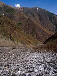
Continuing north on the trail on the eastern banks of the Daryasar River, you will go through a canyon whose orange/yellow walls create a spectacular scene. Soon the canyon ends and you will cross the stream to its western banks over a foot bridge. Make sure you locate this bridge. The stream is too large to cross.
Farther north, a big plain opens up in the middle of the forested mountains. This is the beautiful Daryasar Plain (1700 m). You will see a small hill on the north end of this plain. The floor of the plain is boggy and you might lose the trail here but hike on the extreme western end of this plain until you reach the mentioned hill. The trail makes a turn to the east and traverses the slopes of the hill. This is the perfect spot to take pictures of the slopes of Siyalan rising above the Daryasar Plain. The summit of Siyalan can not be seen but the Kandigan Peak is well visible.
Follow the trail east until it bypasses the hill and turns back north heading down the slopes steeply in the forest to reach the Asal Mahaleh Village.
Essential Gear
Camping Equipment. In early summer an ice axe might come in handy in the steep snow fields in one or two spots.
Parents refers to a larger category under which an object falls. For example, theAconcagua mountain page has the 'Aconcagua Group' and the 'Seven Summits' asparents and is a parent itself to many routes, photos, and Trip Reports.