Notes on Cockscomb Peak climb
These notes are intended to compliment LVHiker's trip report, which was very helpful in our journey to Cockscomb Peak.
Alternate Route beginning. We had trouble finding the right canyon on our first attempt at the peak so made very careful notes on the start of the trail for the second attempt:
1. When you turn onto 157 from US95 South, following the Kyle Canyon signage, you will continue about 18 miles to the Spring Mountain Visitors Center. There are public bathrooms there and the center, which has some useful maps and important information about trails and areas closed due to the fires last summer on Mt. Charleston.
2. When you reach the Visitor's Center SET YOUR TRIP ODOMETER to 0.0.
Route A: At exactly 1.0 miles, you will see a parking area on your right. It is larger than the other pullouts on the road. There is a clear trail into a canyon from here. This is the route described by LVHiker. It is an easy trail along a little canyon.
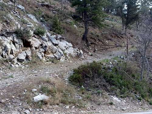
Route B: If you continue .1 miles farther, you'll see a place to park on the left side (across the road from the canyon). If you park here and walk just a few yards farther up 157, there is a gravel road going up the side of the hill on the right hand side. You really can't see it until you go past it because it is hidden by brush and is almost parallel to 157.
Walk up this gravel road going up the hill. The road is blocked by an iron gate but it is easy to get around and there are no signs saying it's private.
Go around the gate and follow the road. It will be joined by the canyon trail further along. Either way it's a piece of cake, but the gravel road is faster.
All instructions between this point and the route up the Stanley B Springs canyon and then on to the ridge and summit are exactly the same as LVHiker, who has documented it excellently.
However, we did not go up the ridge from the Stanley B Springs canyon at the same spot he did so I will describe our route below:
After reaching the old mining sign, and venturing up the Stanley B. Spring canyon, we continued for about 1 mile. We passed two old mines (both gated) and followed a clearly defined trail. We climbed past 2 dry waterfalls. We continued until we reached a NEWLY fallen, slim pine tree. When I sat on the tree that stretched over the trail, it bounced pleasantly! VERY soon after that, there was a very OLD and thick tree down. Ahead, in the canyon, it looked brushy and unwelcoming. At this point, we headed up the ridge which was steep but covered in a thick layer of pine needles and very passable. All the rest that follows is well documented by LVHiker -- you go up and along the ridge, aiming for the base of the false summit on the right hand side, ascend a loose and steep slope, reach the saddle between the false and true summits, and then follow the trail to the right to reach the true summit.
The only other tip I will provide in this report is that our hiking poles made a HUGE difference when coming down the sloggy and steep ridges and slopes. You'll be glad if you have some of your own on this hike.


Comments
Post a Comment