8/11/07 - 8/16/07
Reccomended Reading: Hiking From Here to WOW! North Cascades National Park.
Craig and Cathy Copeland, Wilderness Press, 2007.
My wife and I had been planning this trip ever since we moved to Portland, Oregon in the summer of 2005. Six beautiful days and roughly 50 miles in the North Unit of North Cascades National Park, a real northwest classic. All summer I anxiously awaited the hike, hoping for good weather. It was certainly worth the wait. We pulled into the Glacier Public Service Center (phone: 360-599-2714) as it opened on 8/11 to pick up our required backcountry permits. A very knowledgable ranger who went by the name Sage was there to help us make our final decisions on which backcountry campsites we would be staying at, though you really cannot go wrong on this one.
Directions to the trailhead: From Bellingham, WA drive east on 542 to the town of Glacier (pick-up permit). Then drive ~13 miles and take a left on Nooksack River Rd. This dirt road is just before the bridge crossing the Nooksack River. If you cross the bridge, you have gone too far. After turning on the Nooksack River Rd, take the left fork after ~1 mile on Hannegan Pass Rd, which will dead end at the trailhead. (Roads are well marked)
Day 1: 8.2 miles
As we geared up to leave, two guys dressed head to toe in cammo sporting high powered hunting rifles started up the trail. This was a bit unnerving. As we passed them, they asked if we knew where any blueberry patches where. We declined giving any info, and briskly moved up the trail. The first three miles you are walking up the Ruth Creek drainage with beautiful views of Nooksack Ridge. Ruth Mountain comes into view and then you push up the final mile to the summit of Hannegan Pass (5,066ft). We didnt have the time, but from the pass you can follow a trail north up Hannegan Peak (6,186ft) for great views of Shuksan, the Pickets, and Mt. Baker. If you have an ice ax and crampons, you can follow a trail south from Hannegan pass and climb Ruth Mtn. (7,106ft) as a good day trip.
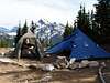
We then decended 1 mile to boundry camp and connected with the Copper Ridge Trail just past the camp. We hiked the final 3.2 miles of the day up Copper Ridge to Silesia Camp, getting great views back west to Mt. Shuksan, Ruth Mountain, Hannegan Peak/Pass, and Mineral King Mountain. Views east were also outstanding of Mt. Redoubt, Whatcom Peak and Mt. Challenger in the distance. Once we arrived at Silesia we set up camp and then took the 15 minute walk down to Egg Lake (campsites available there also), to pump water and have dinner. We had planned to say up late for the Perseids meteor shower, but clouds were moving in and it started to rain shortly after dark.
Day 2: 11.5 miles
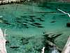
We awoke completely socked in by clouds and it rained off and on all day. I was initially very disappointed, as we had been told that the Copper Ridge walk would be the highlight of the trip. I soon realized that this was just part of the adventure and we proceed up to the Copper Ridge Lookout (6,200ft), down to Copper Lake (campsites available here, 11.5 miles from TH) and then off the ridge to Indian Creek. Coming off the ridge is a real knee-buster if you are toating a weeks worth of gear. There are two braids of Indian Creek that you have to cross. You could ford them in late summer, but we chose to cross the first braid on a log downstream of the trail and the second braid on a log upstream of the trail. Of note, we saw ~100 sockeye salmon spawning in Indian Creek. A beautiful site, almost impossible to think about how far they had come to complete their life cycle. We then made camp at Indian Creek, a nice, heavily forrested site with good trees to hang your food. (19.7 mi from TH)
Day 3: 8.5 miles
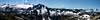
The next morning we got moving early, as our goal was to reach the Tapto Lake Basin above Whatcom Pass. I wanted to spend as much time there as possible. We followed the Chilliwack River for a very brushy 2.2 miles to the Brush Creek Jctn, then headed SE toward Whatcom Pass. Be prepared for somewhat of a bushwack from Indian Creek to Brush Creek. We stopped for lunch at Greybeal Camp, which has a few campsites, one nice spot by the creek with a view of EZ ridge. 2 members of the trail crew were taking lunch here also, we thanked them for all their hard work and moved on. The next three miles to Whatcom Pass are a bit of a grind, but we topped out on the pass by mid-afternoon. We rested and enjoyed the views of the Little Beaver drainage and explored a footpath that went south from the pass to get a close up view of the Challenger Glacier and Whatcom Peak. We then took the very steep footpath north from the pass 1 mile up to the Tapto Lake basin. The trail forks ~0.4 miles up, stay left or you will end up at Middle Lakes (good exploring there also). We pitched our tent between the two largest lakes in the heather filled basin. We soaked in the cool air and alpenglow while eating a delightful beef stroganof backpacker's pantry...delightful might be a strech, but it beats going hungary.
Day 4: Rest 4 miles
We got up with sunrise to enjoy the reflections of the surronding peaks in the lakes. We meandered around the basin, just trying to take it all in that morning. After a short nap, we decided to climb Red Face Mtn. (7,714ft). The summit pinnacle was rotten looking, so we just walked the ridge from near the summit back west to an unnamed highpoint anchoring the ridge. If you have come this far, you have to scramble up this ridge. (unless you have a bigger climbing objective in mind)...Amazing views!
Day 5: 10.8 miles
Headed toward home. Said goodbye to Tapto Lakes, hope to come again. We traveled 6.2 miles back down to the Brush Creek Jctn, then another 1.5 miles to the cable car crossing over the Chilliwack River. Talk about good, wholesome fun. We then walked the final 2.6 miles to Copper Creek Camp, passing US Cabin Camp along the way. We soaked our tired feet in the creek, built a small fire, and enjoyed our final evening in the park.
Day 6: 7.4 miles
Packed up early and humped it out. I had planned on stopping to climb Hannegan Peak on the way out, but cloud cover was obstructing the views.
We made it to the car by 10:30am and headed to Marblemount. Got a room, showered, and grabbed a burger at Good Eats. We drove up highway 20 to Diablo Lake and then came back to Marblemount. The next morning we got up and did a little recon work for our next trip, we drove the Cascade River Rd. and then headed back to Portland. This was a great backpacking trip, it definately made me want to take some more advanced mountaineering courses so I could attempt some of the more difficult peaks in this area.
The only downer: Flies and mosquitos were everywhere! Mosquitos greeted us in a fog every morning, then the black flies moved in during the day. The black flies could care less about DEET. Then every evening, the mosquitos came back. Only defense is perpetual motion and the highest ridges...Good Luck.
Comments
No comments posted yet.