
-
 7858 Hits
-
 86.85% Score
-
 23 Votes
|
|
Mountain/Rock |
|---|---|
|
|
46.21900°N / 10.87250°E |
|
|
Trentino Alto Adige |
|
|
Trad Climbing, Sport Climbing |
|
|
Spring, Summer, Fall |
|
|
7710 ft / 2350 m |
|
|
Overview
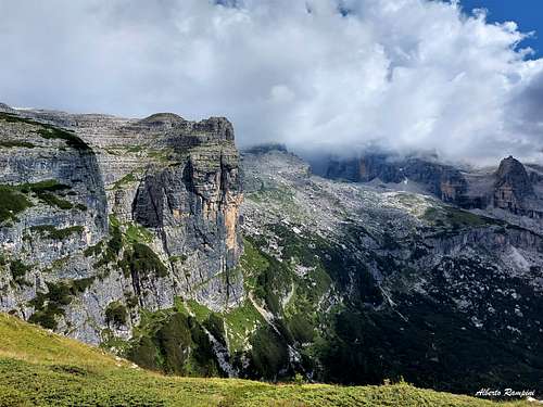
Corna Rossa m. 2350
The Western edge of the Grosté tableland, South-West to the namesake pass, dominates the Vallesinella head with a long and steep rocky wall facing West, South-West and South, belonging to the Brenta Group, Grosté Massif. Cut by several gullies, this black, reddish and grey wall is shaped in 8 towers, from 300 to 150 meters high. Amongst these towers the culminating point of the walls is located on the first peak, lying on the left hand side (West), the Corna Rossa. So from left to right we can count: Corna Rossa, Torrione S.A.T., Torrione Lancieri, IV Torrione, V Torrione, Torrione Settimo Bonvecchio, Torre Daniela, VIII Torrione. On the contrary, the North-East side shows several short rocky steps, degrading gently towards the Grosté karst tableland and the Rifugio Graffer. So, unlike the majority of the Dolomites peaks, which almost never show a weak and gentle angled side, the descent from Corna Rossa is easily done on its NE side.

On the opposite steep and attractive walls facing Vallesinella we can find a great number of beautiful climbing routes Dolomites style. Corna Rossa was well known for its fine classic routes having every kind of difficulty, now also for its moderne ones, realized in the late years. The possibility to climb on Corna Rossa in late spring, when the highes summits of Brenta Group are snow-covered is one of the reasons of Corna Rossa popularity.

|

|
Getting There
There are two starting points to approach Corna Rossa:
- From Vallesinella, 4 km. from Madonna di Campiglio (TN) m. 1514, the main center in this area - From the upper Station of Grosté cable-car, starting from Passo Campo Carlo Magno m. 1651, a few km. North to Madonna di Campiglio
Road access to Madonna di Campiglio m. 1514
- Coming from A22 Brennero Motorway (direction towards South) exit Trento Centro, then follow the SS 45 towards Riva del Garda and Tione, getting to the village Le Sarche. From here take the SS 237 reaching Ponte Arche and Tione. In Tione turn to right and follow the Val Rendena road getting to Pinzolo and Madonna di Campiglio.
- Coming from A22 Brennero Motorway (direction towards North) exit San Michele Mezzocorona, then take the Val di Non road, getting to Cles, Malé and Dimaro. In Dimaro leave the main road and turn to left on the Val Meledrio road, reaching Folgarida, Passo Campo Carlo Magno and Madonna di Campiglio.
From Madonna di Campiglio m. 1514 a level road reachs the parking of Vallesinella (4 km. From Madonna di Campiglio). Pay attention: on Sundays from June 15th to September 21th, from 9.45 to 18.15, and all the days from June 28th to August 31th, same time-table, the road is closed to the private cars. In these periods a minibus-service starting from Madonna di Campiglio is available. In the same period paying parking in Vallesinella (5 euro). By walking in 45 minutes.

|

|

|
Walking approach
- From Vallesinella take the path n. 382 towards Rifugio Graffer, getting to the Upper Malga Vallesinella m. 1681. Corna Rossa is quite visible from the approach. After half a hour by walking, the path exits the larch-wood. At the wide hairpin towards left, leave the main path following a narrow track getting the bottom of Corna Rossa (I Tower) on the left edge of the wide wall (1,30 h. from Vallesinella). Walking approach from Grosté
- From the upper station of Grosté Cable car take the path n. 316 to Rifugio Tuckett. The walls are reached after about 15-20 minutes by walking.

Main Routes Overview
Corna Rossa main routes
According to the Italian climbing areas habit, trad routes grades are expressed in UIAA Scale, while the modern routes ones are expressed in French Scale.
I Tower (Corna Rossa)
- I suoni delle Dolomiti Alberto Damioli, Massimo Comparini 2009 September 4th, sport climb
- Via Quinto e Lina 6a+ (6a obbl.), 220 m. Moderne route running along grey and black slabs on the left of Corna Rossa yellow overhangs

|

|
- Via Donato-Zeni 300 m. Old artif route
- Via Zordano 6c max, (6b obbl.) 300 m. Bolts, moderne route. Running on the slabs on the right of the route "Donato Zeni" - Via Zordano report
Torrione S.A.T.
- South-West Ridge Via Andreotti-Bozzi-Andreolli-Casiraghi 1972 V+,VI 300 m. - A classic route, more hard than the Detassis-Vidi, running on the left
- South-East Ridge Via Detassis - Vidi – IV, V, 300 m. - Bruno Detassis and Natale Vidi august 1946 - Classic route - Sass Baloss Detassis-Vidi report
- South-East Ridge Via Nella Detassis - IV, V (3 moves), 300 m. Bruno e Nella Detassis 1942 - Sass Baloss Nella Detassis report

|

|
Torre Lancieri
- Via Marchiodi IV, V, 200 m. - C. Maestri, T. Celva 1972 - Classic route
IV Torrione
- Via Andreolli-Bazzi-Casiraghi III, IV, IV+, M. Andreolli, R. Bazzi, J. Casiraghi 1973 - Classic route
Torrione Bonvecchio
- Dotto 6c max, 150 m. - Moderne route

|

|
Torre Daniela
- Andreolli-Casiraghi-Miglio - III, IV (1 pitch), 150 m. M. Andreolli, J. Casiraghi, F. Miglio 1972, October 8th - Classic route - Sass Baloss route report
- Un indovino mi disse 5c max, 120 m. - Bolts, moderne route - Route report
Descent: Scrambling down easily along short steps, then crossing scree and meadows heading to North (left) to reach the Rifugio Giorgio Graffer (15 minutes). From the hut a well worn path descend to Vallesinella (1 hour).
More climbing info: AngeloElli
")
|
, Brenta Dolomites")
|
Red Tape

No fees no permits required. All the Brenta Group had been acknowledged inside UNESCO WORLD HERITAGE list and requires the best care and respect from its visitors. Pay attention: on Sundays from June 15th to September 21th, from 9.45 to 18.15, and all the days from June 28th to August 31th, same time-table, the road Madonna di Campiglio-Vallesinella is closed to the private cars. In these periods a minibus-service starting from Madonna di Campiglio is available. In the same period paying parking in Vallesinella (5 euro).
More info on SP about Dolomites UNESCO World Heritage: Dolomites, living mountains

|

|
Where to stay

- Rifugio Giorgio Graffer m. 2261 on Grosté - S.A.T. (Società Alpinisti Tridentini) Sez. Trento - Open from June to September and in wintertime Place: 68 (Winter shelter 2) Phone +390461981871, fax +39 0461986462, Info. +390465441358, Guardian Ph. +390465440539 e-mail: rifugio@graffer.com
- Rifugio Vallesinella m 1513
When to Climb
Best season goes from June to October
Meteo
")
Guidebooks and Maps
Guidebooks


"Dolomiti di Brenta vol. 3 - Vallesinella, Campa e Catena Settentrionale" by Francesco Cappellari - Ed. Idea Montagna
"Dolomiti di Brenta" by Gino Buscaini and Ettore Castiglioni - Collana Guide dei Monti d'Italia C.A.I. - T.C.I.
Maps
Gruppo di Brenta - Kompass n. 73 1:50,000 Gruppo di Brenta - Kompass n. 688 1:25,000
External Links