
-
 4986 Hits
-
 81.18% Score
-
 13 Votes
|
|
Mountain/Rock |
|---|---|
|
|
37.64173°N / 13.27908°E |
|
|
Hiking |
|
|
Spring, Summer, Fall, Winter |
|
|
2116 ft / 645 m |
|
|
Overview
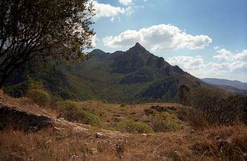
 Coste di San Antonio (02-10-2002)
Coste di San Antonio is a beautiful half days hike in the Monti di Palazzo Adriano, a part of the Monti Sicani coastal range in southwestern Sicily. Located in the Valle di Fiume Sosio region it offers a good impression of the southwestern coastal range - mostly soft hills, some rocks and impressive rockfaces - and some of the last woods on Sicily island.
Located northwest of the town of Agrigento, the Fiume Sosio valley and its protected site “Riserva di Monti di Palazzo Adriano e Valle del Sosio” offers some interesting hikes in a remote Sicilian landscape. The Coste di San Antonio hike can easily be prolongated by climbing some adjacent peaks or ridges using old trails and fire roads.
Getting There
 Castello Gristia from Coste di San Antonio (02-10-2002)
The trailhead is at the ex railway station at San Carlo between the villages of Burgio (south) and Chiusa Sclafani (north).
You reach San Carlo on road SS 386 coming from Ribera at the southwestern coast between Agrigento and Mazara del Vallo. From Palermo take SS 21 to Bolognetta and SS 118 to Chiusa Sclafani; proceed then on SS 386 to San Carlo.
Some other Strade Provinciale or Strade Statale can be used to reach San Carlo, normally they are winded and sometimes in a bad state:
- from Menfi (southwest coast) via Sambuca and Giuliana: SP 41 and SS 188
- from Sciacca (southwest coast) via Santa Ana
From the north coast, the east coast and from central Sicily the journey is very long and complicated - Coste di San Antonio is a hike from nearby accomodation.
Red Tape & Mountain Conditions
 Cozze Gigante and Portella Rossa from Castello Gristia (02-10-2002)
Red Tape
Coste di San Antonio is part of a protected area, the “Riserva di Monti di Palazzo Adriano e Valle del Sosio”, so there are some restrictions to bear in mind:
- no camping
- no fires
- no collecting of plants, parts of them or seeds
- do not leave the trails
- do not remove or disturb the animals and birds
Please respect the wood in this region, it is one of the last closed woodlands on the island !!
Mountain Conditions
Coste di San Antonio is, due to the moderate hight and the Mediterranean climate, a whole years hike.
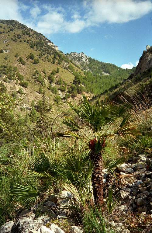
Best time is early spring until early summer (February through May) and October/November. February through early April there are wildflowers blossoming. You might see many orchids within the protected site.
June through August is normally too hot - you would not like hiking with 45 grade centigrade ...
You need good hiking shoes, good sun protection, enough water and a good sense of orientation, too. Long trousers, though they can be a torture during hot days, are recommended (thistles, thorny bushes, ticks, snakes).
Routes & Trails
 Route overview
From the parking area at the old railroad station follow the railroad grade (the rails have been removed !) to the northeast. The steep rock of Castello Gristia, an old ruined castle, can be seen in front of you. After a while you reach the beautiful railroad bridge over river Sosio (Viadotto Gristia). Before you enter the bridge take the trail leaving to the left and descending into the Sosio valley.
The trail passes a house and a pine wood and arrives at the river. It crosses the river then and continues on the other side to the left. You have to overcome some fences here – this can be a nasty piece of work (much barbed wire used, have fun ).
The trail ascends slowly, does some switchbacks and arrives at a trail junction. Take the right trail, ascending the north slopes of Castello Gristia rock; the left trail is the descending route.
After some zigzagging the trail arrives at the plateau of Castello Gristia with the ruin remnants and a nice view into river Sosio valley, to the southern coastal plain and to the Monti Sicani. After a break continue on a trail leading to the southeast, partly following the ridge, partly traversing the northeast slopes of that ridge. The trail joins a forest and fire road, follow the road to the left, arriving at Portella Rossa with a road junction.
Castello Gristia from summit (02-10-2002)If you follow the right road you can climb the summit of Cozzo Gigante (822 m, some parts are off-trail) and proceed into the San Adriano woods with the ruins of the San Adriano church (2 to 3 hours more).
For Coste di San Antonio take the left road and follow this road always to the left descending after a while and some curves back into river Sosio valley. At a left turn of the road a trail branches off to the right. Follow this trail up the south slopes of Coste di San Antonio to the summit. The last part of the ascent is more or less off trail. Good views into the Sosio valley region and onto Castello Gristia.
Descend back to the fire road and follow the road to the right until you reach a fire protection clearing. Traverse this clearing to the left to a trail on the other side. You soon reach the junction with the trail ascending to Castello Gristia. Descend to river Sosio and follow the way back to San Carlo railway station.
 Caltabellotta range and San Carlo from Castello Gristia (02-10-2002)
Before you reach the railroad bridge there is another road branching off to the right. This road leads up to the southeast slopes of Monte Lucerto (739 m), the neighbouring summit of Coste di San Antonio which can be easily climbed, too. Monte Lucerto has nearly no woods so the climb is not recommended during hot days.
Accomodations, Culture, Maps & Guides
 River Sosio valley and summit (02-10-2002)
Accomodations
You find accomodations mainly at the nearby southwest coast, which can be highly recommended for a bathing stay. Between Selinunte and Eraclea Minoa there are many possibilities to lodge in hotels or holiday houses / apartments. You will find free apartments signposted with telephone numbers. Or ask in a local bar for good accommodations.
At Eraclea Minoa there is a campground and a great beach.
Culture
You will find some important greek remnants along this coast:
the old town of Selinunte with important greek temples
the little greek town of Eraclea Minoa with an interesting greek theatre
the town of Agrigento (Akragas) with the world famous Valle dei Templi
Map & Guidebook
Good maps are rarely to purchase.
The aapt (Azienda Autonoma Provinciale per l´Incremento Turistico di Palermo – oh yes, that´s the denotation) offers a 1 : 50.000 scale map:
Carta dei sentieri e del paesaggio dell´alto Belice Corleonese,
Tavola III: Monti Sicani, Valle del Fiume Sosio
The hike is described in:
Mithra Omidvar
Sizilien und Liparische Inseln
Die schönsten Tal- und Höhenwanderungen
Bergverlag Rudolf Rother
This guidebook should be available in English and French, too. The maps and descriptions in this books are normally sufficient.