About this page
This report is both in English and French. - Français suit plus bas.English version
SANGAY 5230m (Ecuador / Andes / Cordilliera Oriental), normal route (from La Playa / southwest face), 5-day trek / +1700m for the ascent itself, with a native guide of Guargalla community and his 2 dogs (May 2005 / loose humid weather):
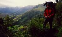
![Just the time to appreciate...]() The background...
The background...
Sangay is one of the most active volcanoes on Earth and, often the most active of the American Continent as it has been in continuous eruption for several centuries now. The rate of its explosive eruptions can be as high as dozens per hour. During my visit, May 2005, the volcanic activity had decreased to "gentle" behaviour of two or three explosions per hour… The explosive eruptions are mainly caused by gases imprisoned due to the fill-up of Sangay craters and which explode, once a limit pressure is reached, throwing away their “plug” and rising into the air. The eruption features a gas jet of 50 to 150 meters that dissipates in a column rising 500m above the Sangay summit. According to many, Sangay is the most hardcore of
Ecuador’s “Top Ten” (+ 5000m summits). Indeed, besides the volcanic activity, the approach to the volcano is difficult (it is a two / three days walking distance from the closest villages) and its climate is particularly wet and rainy. Sangay itself is in the clouds most of the time, so much that its photos are scarce! In our five-day journey, we saw the volcano only for two or three hours. Sangay approach is a trek on muddy trails and partially in rain forest…
![Western side of Sangay]() Approach from Alao
Approach from Alao
My first attempt to climb Sangay was from the village of Alao, where Sangay National Park main office is located and the usual start point for the ascent of the volcano. Nevertheless, my attempt ended quickly. The locally well known Caz brothers were the only ones of the Cooperative of Alao native guides who had the minimum necessary equipment to undertake the ascent! Now aged above 50, they have a strait forward policy: negotiate an “all inclusive contract” for a six day expedition, and do everything to sabotage the venture as soon as possible! In other terms, to earn the maximum with a minimum of effort… In my case, the expedition lasted only two days, far away from the slopes of Sangay. However, they only got from me a payment directly function of their “services”.
After the bad experience in Alao, I trusted an address recommended by the French backpackers’ bible, Le Guide du Routard! The guidebook suggested an approach from the village of Guargalla, southwest of the National Park, hiring someone from the local cooperative of native guides. Indeed, the young guides there were very motivated and well equipped. They were only asking for one thing: to be trusted for an ascent of Sangay or even of other high summits such as
Cotopaxi and
Chimborazo.
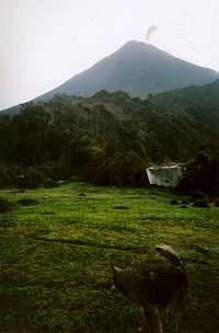
The approach started at the village of Guargalla (3300m). It was somehow difficult to evaluate the distances, as a pointer, from Guargalla we walked one day to reach the entrance of the National Park. The whole day, we hiked up and down between 3300m and 4100m of altitude. Although the section between Guargalla and the Park does not appear in any topo-guide, it is actually a paradise: the “Paramo” (kind of altitude grassland) massif there, with tens of summits above 4000m, is easily scalable while hiking. If you have difficulty to imagine a cow grazing alone, far away on a 4000m ridge, that’s the place to go!!! Indeed, the hacienda Guargalla has hundreds of livestock grazing free in a wilderness of tens of square km of green mountains. Surely the happiest cattle on earth! At the entrance of the park, there is a choza (a straw roof shelter used by the person in charge of the cattle when the animals venture into the park in search of additional food). This place is called Plazapampa. It is a big plateau that is visible from far way (altitude = 3600m?). We were lucky to have a clear view of Sangay during a decent period of… one hour!
![Sangay from Plazapampa]() Plazapampa
Plazapampa
The second day, we continued in an up and down mode between altitudes of 3400 and 4100 meters. The landscape was now a kind of typical rain forest in formation, less dense than the famous Amazonia “next doors” (east of Sangay / Cordillera Oriental). The vegetation steadily fought back to re-conquer the trails opened by the rare hikers. Trails that furthermore, crossed many brooks. Delfin, my guide, used a machete, not for opening the path for us, but rather to cut one wide enough for his horse who carried out our bags and the cooking equipment. I was impressed by the horse and his master negotiating tricky / dangerous passages; especially because I was told by the guides in Alao that except the short dry season (December-January), it was impossible to go farther than Plazapampa with mules. Delfin’s opinion was different: “The horse is like the hiker; If he is trained for such a terrain, he’ll make it ! if not, it will be a disaster!” I though to myself, it’s pretty much the same for the muleteer, Delfin knew perfectly how to direct and which way to send his horse. A less experimented fellow would have sent the horse to his death…
In the evening we arrived to “La Playa” (3600 meters), at the foot of Sangay. The spot is the final and flat portion of a red lava flow coming down the volcano and is surrounded by two brooks. There, another Choza is specially built to serve as shelter for those attempting the ascent. That evening, the volcano remained hidden in clouds...
![Sangay from La Playa : at...]() La Playa
La Playa
We set the alarm for 1 am to start the ascent at 2 am: only time of the day the clouds might be low enough for a chance of ascending a cleared summit. At 1 am, clouds were thick so we started to discuss and finally decided to give it a try at about 3 am. 1700 meters of elevation was ahead of us. Sangay slopes were quite gentle although the route had several spots of about 45 degrees. There was no more snow on Sangay; the small glacier that is seen on the rare photos of Sangay had disappeared and the snow that had fallen the day before (see picture of Sangay taken from Plazapampa) had already completely melted. Above 4400 meters, the terrain became particularly strange: volcanic ash soaked with water had frozen! It was not as slippery as ice but the adherence was quite limited when on 45 degree slopes. Not that the route would have been “involving” but just thinking of sliding down 300m or more and having to climb back and we decided to wear our crampons! Delfin’s 2 dogs, Bamby and Daisung, used their claws!! I’m pretty much sure these two found me particularly slow! Each time they decided to move - upward they were 100m in elevation a head of me in just few minutes! The time I caught up with them, they usually opted for a nap!!!
Sangay possesses 3 craters. For guides, the ascent ends on the summit plateau, they do not venture on any of the actual craters … Nevertheless, Delfin followed me up to the highest crater, the only one (of three) to be active at that time. On the crater rim, we found 2 high points. We went to the first one, and then I wanted to contour the crater to go to the second one that was few metres higher. I faced Delfin’s veto: "too dangerous!" He reminded me the previous eruptions had literally swept this side of the crater. He had a point, I accepted and we went down to the summit plateau for a break when… suddenly there was another eruption: the highest point of that crater rim vanished in a heap of volcanic gases! Hence proved! Delfin reassured me: “You know, the summit of an erupting volcano is quite a relative notion, the craters grow or collapse, eruption after eruption.” I now suddenly understood how people can loose conscious, suffocated by the gases of Sangay, as this fact is underlined in some trip reports. Convinced by the demonstration, we started the descent followed by the two dogs; leaving behind us the pleasant heat of the craters.
![Eruption of Sangay]() Explosive eruption, Sangay style!
Explosive eruption, Sangay style!
The descent was almost over that it started to rain, as it’s usually the case in Sangay National Park. It was pretty much at the same moment that I started to feel some light burns while breathing. The summit gases had taken their toll! I was thinking to myself what it could be like to be imprisoned in one of Sangay eruptions...
Our adventure in Sangay lasted 5 days in total and 3 inside the National park. During these three days, we met nobody! And during the 2 other days, we crossed only some people of the native community, but no other tourist, whether Ecuadorian or foreigner.
Version française
SANGAY 5230m (Equateur / Andes / Cordilliera Oriental), voie normale (depuis La Playa / flanc sud-ouest), Trek 5jours / +1700m (l’ascension proprement dite), avec un guide de la communauté autochtone de Guargalla et ses 2 chiens (mai 2005 / temps changeant et humide) :
![Sangay native guide]() Delfin, le guide, et ses deux chiens: Bamby et Daisung
Delfin, le guide, et ses deux chiens: Bamby et Daisung
Sangay est un des volcans les plus actifs de la planète et a coup sur le plus actif de tout le continent américain. Il est en éruption de manière continue depuis des siècles à raison parfois de plusieurs dizaines d’explosions par heure… En mai 2005, l’activité volcanique s’était assagie à « seulement » 2 à 3 explosions à l’heure… Il s’agit principalement de gaz qui s’échappent du coeur de la terre, qui se trouvent prisonnier dans des cratères rebouchés par la terre et autres pierres et qui, montant en pression, finissent par faire sauter le « bouchon ». Alors une colonne de gaz chauds s’échappe instantanément sur 50 à 150m avant de se dissiper sur des hauteurs pouvant dépasser les 500m. Selon beaucoup de gens, le Sangay est le plus « chiant » (hardcore en anglois) des 10 sommets de plus de 5000m d’Equateur. En effet, en plus de l’activité volcanique, il y a la difficulté d’accès (le volcan est à 2 / 3 jours de marche des derniers villages) et son climat particulièrement humide (il pleut la plus part du temps). Le Sangay lui-même est dans les nuages de manière quasi permanente à un tel point que les photos de Sangay sont une denrée rare ! Voyez donc, en 5 jours il ne nous a été visible que 2 a 3 heures ! Le trek d’approche se fait donc sur des sentiers boueux et en partie dans une forêt tropicale… Ma première tentative au Sangay s’est faite depuis le village d’Alao, principale porte d’accès au Parc National Sangay (situé à l’Ouest de celui-ci) et le point de départ habituel pour l’ascension du Volcan. Pourtant ma tentative a tourné court. De toute la coopérative des guides autochtones d’Alao, seuls les frères Caz avaient l’équipement minimum nécessaire à une telle ascension. Or, à 50 ans passés, leur politique est simple : négocier un contrat tout compris pour 6 jours d’ascension au prix fort puis, tout faire pour saboter l’entreprise le plus rapidement possible pour toucher le maximum pour un minimum d’effort… Dans mon cas le trek n’a duré que deux jours loin des pentes du volcan, mais ils n’ont obtenu de moi qu’un paiement en rapport avec leur prestation… Passée la mauvaise expérience d’Alao, je me suis fié à une adresse recommandée par… le Guide du Routard ! Il s’agissait d’une approche depuis le village de Guargalla au sud-ouest du Parc National en faisant appel aux guides autochtones de ce coin regroupés eux aussi en coopérative. Là, les jeunes guides, très motivés et bien équipés n’attendent qu’une chose : qu’on leur fasse confiance pour faire l’ascension du Sangay et même d’autres grandes montagnes comme le Cotopaxi et le Chimborazo ! Difficile d’évaluer les distances, mais depuis le village de Guargalla (3300m) on a marché un jour pour arriver à l’entrée du Parc National Sangay.
![Parque Nacional Sangay]() ici commence l'Amazonie!
ici commence l'Amazonie!
Toute la journée on a fait le yo-yo entre 3300m et 4100m d’altitude. Le coin entre Guargalla et le Parc ne figure dans aucun guide-topo mais c’est un vrai paradis : Un massif avec plusieurs dizaines de sommets de plus de 4000m couverts par le « paramo » (genre d’herbage d’altitude) et accessibles en randonnant. Si vous avez du mal à concevoir une vache brouter seule, loin de tout, sur une crête à 4000m, c’est là qu’il faut aller ! En effet, L’hacienda Guargalla a des centaines de bêtes qui végètent tranquillement, dans un espace libre et sauvage de plusieurs dizaines de km2 de montagnes de verdure : Certainement les bovins les plus heureux de la planète ! ! A l’entrée du Parc, il y a un choza, abri / baraque à toit de paille, qui sert au préposé au suivi du bétail quand il faut s’occuper des bêtes qui se sont aventurées dans le parc à la recherche de plus de nourriture… Le coin s’appelle Plazapampa, un grand plateau visible de loin (3600m ?), et nous avons eu la chance de pouvoir voir un Sangay dégagé pour un temps appréciable… d’une heure ! Le deuxième jour, on a poursuivi en mode yo-yo entre 3400 et 4100m d’altitude. Le paysage est maintenant du type forêt tropicale en formation, c’est à dire bien moins dense que la fameuse Amazonie qui est tout près, juste sur le versant Est du Sangay et de la Cordillère Orientale. Ici, la végétation gagne régulièrement le dessus sur le sentier peu fréquenté qui croise un nombre important de ruisseaux. Delfin mon guide utilise une machette mais ce n’est pas pour ouvrir le chemin pour nous, mais plutôt pour tailler un passage suffisamment large pour son cheval qui porte nos sacs et le matos de cuisine. J’étais impressionné par le cheval et son maître travaillant pour négocier certains passages pentus et boueux, et cela d’autant plus que les guide d’Alao eux, m’avaient dit qu’en de hors de la saison sèche (décembre – janvier), il était impossible d’aller plus loin que Plazapampa avec les mules. Delfin, quant a lui, me dit que le cheval est comme le randonneur, s’il a l’habitude de ce genre de terrains, il les passe et s’il n’a pas été entraîné pour ça, c’est la catastrophe ! Je pense que la même remarque est valable pour le muletier, Delfin savait parfaitement par ou faire passer son cheval, un autre type moins expérimenté aurait envoyé le cheval au casse-pipe… Le deuxième soir on arrive au lieu-dit La Playa 3600m au pied du Volcan, il s’agit de la partie finale et plate d’une coulée de lave rouge, entourée de deux ruisseaux. Là, un autre Choza a été aménagé spécialement pour servir d’abri pour approcher Sangay. Le volcan, lui, était caché dans les nuages.
![Sight from the top of Sangay]() sur le plus haut cratère
sur le plus haut cratère
Réveil programmé pour 1h du matin, seule façon de garantir des nuages suffisamment bas pour pouvoir atteindre un sommet dégagé. Les nuages étaient épais, on s’est questionné, on a réfléchi et on a fini par partir à 3h. 1700m de dénivelé nous attendaient. Le flanc de la montagne avait une pente moyenne faible mais il y avait des passages à 45 degrés. Il n’y avait plus de neige, le petit glacier qu’on voit sur les rares photos du Sangay a bel et bien disparu et la neige tombée la veille avait fondu. Passé 4400m le terrain devient particulièrement étrange : le cendre volcanique imbibé d’eau avait gelé ! Ce n’est pas aussi glissant que la glace mais l’adhérence est limite sur les passages à 45 degrés. La « voie » n’est pas ce qu’on pourrait qualifier « d’engagée » mais rien que d’envisager de glisser sur 300 m ou plus et d’être obligés de remonter le tout, nous fait mettre les crampons ! Quant aux 2 chiens de Delfin, Bamby et Daisung, ils ont sorti les griffes !! D’ailleurs, ils ont dû me trouver particulièrement lent, ces 2 bestioles : à peine ils se mettaient à marcher qu’ils me mettaient 100m de dénivelé dans la vue ! Le temps que je les rattrape ils se payaient une sieste !!!
![Sangay doubtful gazes]() “atmosphere!”
“atmosphere!”
Revenons au volcan: le Sangay possède 3 cratères. Pour les guides, la course se termine au plateau sommital, ils ne tiennent pas à s’aventurer au niveau des cratères… Pourtant, Delfin m’a suivi jusqu’au cratère le plus haut, le seul des trois à être actif alors. Dans le périmètre du cratère on trouve 2 points hauts. On est allé au premier, puis, je voulais contourner le cratère pour aller au second de quelques mètres plus haut que le premier. Là, j’ai eu le veto de Delfin : « trop dangereux ! ». Il me fait remarquer, à juste titre, que les précédentes éruptions ont littéralement longé ce coté-ci du cratère, et il avait raison. On a alors descendu au plateau sommital pour casser la croûte quand… une éruption de plus : le point culminant du volcan disparaît dans un amas de gaz volcaniques. CQFD comme on disait en math ! Delfin me rassure en m’apprenant que le sommet d’un volcan en éruption est une notion toute relative, qu’il pousse ou s’effondre au gré des éruptions et selon l’activité des différents cratères. Je comprenais tout à coup comment on pouvait perdre connaissance, asphyxié par les gaz du volcan comme le soulignaient certains topo… Convaincu par la démonstration, j’ai alors entamé la descente en compagnie de mon guide et de ses deux chiens même si la chaleur du cratère nous était bien agréable. Ce n’est que vers la fin de la descente, sous la pluie, que je me suis aperçu que je ressentais des brûlures quand je respirais. Rien que l’air du sommet avait provoqué des mini brûlures dans ma voie respiratoire… qu’est ce que cela aurait fait de se retrouver prisonniers des gaz d’une éruption ?!!
Notre aventure Sangay a duré 5 jours au total dont 3 à l’intérieur du Parc National. Pendant ces trois jours, nous n’avons rencontré personne ! Et les 2 autres jours, nous n’avons croisé que quelques personnes de la communauté mais aucun autre touriste, même équatorien !
Comments
No comments posted yet.