Add Heading Here
* Note: Route traces shown are planned, not actual; but our traveled route varied little from the plan.
Thanks to @SawtoothSean for some route info on this one.
After a few family trips in the familiar terrain of the Wind River range and the North Cascades, I wanted to try someplace new, and the Sawtooths of Idaho met that requirement. Having spent a little time skiing out of the Bench Hut (operated by Sun Valley Trekking), I knew the range was steep, wild, and rocky; and the potential for an epic family trek in the mountains was real. Some time on the web, reading guidebooks, and hours on Google Earth left us with a planned route consisting of approximately 37 miles including side trips, and something in the neighborhood of + and - 12,000 feet of vertical, with about half of the route being off trail and cross country, with a few summits to bag as well. We navigated it all successfully--with the exception of one aborted summit attempt--and had an outstanding time with the granite and gneiss summits, clear mountain lakes, and forested trails. Viva Sawtooths!
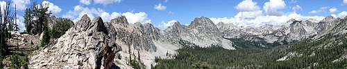
The route:
In the Iron Creek trailhead.
Down the North Fork of Baron Creek via an off trail lake above Alpine Lake.
Up to Baron Lakes.
Off trail over a low pass to the upper Fishhook basin and over to a lake below Mt. Limbert.
North Over the southeast ridge of Limbert and the high pass between Mt. Carter and Mickey's spire to the upper Goat Lake drainage.
Down and out past Goat Lake and back to the Iron Creek trailhead.
The team:
Mom, Dad, two boys age 12 and 10.
My wife and I each carried around 35% of our body weight (~65 lbs for me), and we keep the boys at around 20% of body weight. Not ultralight backpacking, but pretty good for seven nights in the mountains with a wee little bit of climbing gear.
Day 1:
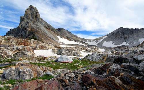
Drive from SLC, UT, trek from the Iron Creek trailhead to lake 8965 above Alpine Lake.
The Iron Creek trailhead was busy, as promised by the guidebooks, and we encountered many day hikers and overnighters on the trail bound for Sawtooth Lake. The unsettled weather gave us a bit of intermittent light rain, but nothing drenching. Our progress on the trail was good, which was a notable improvement over the kids' first-day performance in the Winds last year. We made quick time to Alpine Lake, navigated around, past several campers, and proceeded up the talus field below Alpine Peak, leaving the crowds below.
Near the top I spent a little time scouting the safest route around and over the headwall of the talus field, which we maneuvered around to the east. Dark storm clouds built in strongly as we dropped into the high hidden valley below Alpine Peak. We engaged haul-ass mode and got the tent up and the rain fly on just as the drops started to fall in earnest. Everyone stayed dry except for me, who dutifully collected water for the evening, just in case the rain continued into the night.
The weather did clear for dinnertime, and we enjoyed an evening of complete solitude on a narrow isthmus separating the two pristine subalpine lakes. Night brought more wicked rain, hail, lightning, and thunder, all of which we enjoyed from the shelter of our tent.
Day 2:
After pushing up and into the subalpine on the first day, we stayed the second day at our private lake and made a quick summit grab to Alpine Peak. Our route followed a mafic dike that angled up the east slope to the summit ridge. Then along the ridge to the summit. Three hours round trip.
On the summit of Alpine Peak.
The route is a non-technical scramble, but I'm a firm believer in helmets on steep rubble. You'll see us wearing them throughout these photos.
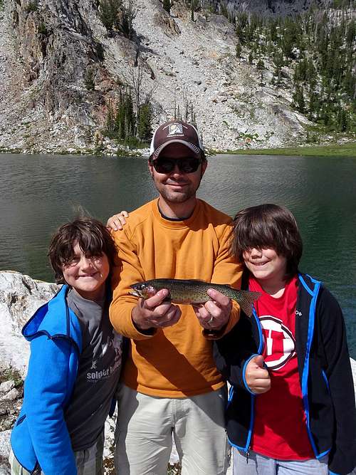
With continued black clouds on all horizons, we did not linger long on top. Back down to our Isthmus Camp for a little fishing:
Day 3:
A steep off trail descent to lake 8270 behind Sawtooth Lake, down the North Fork of Baron Creek, almost 4,000 feet of descent in total; then up the main fork of Baron as far as we could get.
Leaving the subalpine heights.
Storm clouds built as we dropped into the headwaters of the North Fork of Baron Creek. By the time we started down the overgrown and brushy trail, rain was falling heavily. Rain, whacking through wet bush, and a couple complex creek crossings dampened some of the enthusiasm, but made for some very distinct memories.
We did pass one group of two backpackers on their way up the North Fork.
Fording the North Fork of Baron Creek.
Once we hit the junction with trail along the main fork of Baron Creek, the rain departed, the sun returned, and we took some time to dry out. Although I had tentatively scheduled a trek all the way up to Baron Lakes for today, I knew it would be a big push under the best of circumstances. Considering the wet flogging we received on the way down North Baron and the resulting hit on the kids' enthusiasm, our pace and ambition had waned, and it was clear we would stop for the night somewhere along Baron Creek. After finding the established Moolack camp a few miles up the canyon severely lacking (dirty, too close to the trail), we opted for a more secluded spot on an abandoned gravel channel near the creek. We dried out a little more, played in the creek, and enjoyed a peaceful dinner.
Day 4:
A couple thousand vertical feet up the remainder of Baron Creek to the stunningly beautiful Baron Lakes. We did not encounter anyone on the trail, and were pleasantly surprised to have the lake to ourselves.
We made camp lakeside below a fabulous glacially polished granite slab. The fish weren't biting for us, but we enjoyed ourselves nonetheless.
Loving the granite slab.
Baron Lake and Monte Verita.
Day 5:
Day five would take us cross country, up to the low pass separating the Baron Creek and Fishhook drainages. There was some bushwhacking, steep talus, creek crossings, log hopping, and some entertaining route finding. Our goal was a small lake at about 8,888 feet, below Mt. Limbert.
Navigating through the Braxon Lakes drainage east of Baron Lakes was probably the most challenging leg of day five. Thick forest and no sight lines left navigation to the compass and map interpretation--nothing that would get you lost--but maintaining the most efficient route was a bit of a crapshoot. Regardless, we made the pass and could see east and north to the day's destination as well as what would be the ultimate crux of our entire journey in the high pass further out on the horizon.
After descending into the Fishhook Creek drainage, we countoured around and above the Stephens Lakes, around a large blocky summit, and then ascended a beautiful creek to the lake at 8,888, hereafter called Crazy Eight Lake in our family.
We took a quick dip in the lake and the proceeded skip rocks, relax, and catch fish at a silly rate.
Dad guts and cleans.
Mom cooks.
That is the arrangement.
Day 6:
A couple thousand feet of vertical via steep talus and boulders to the high pass around 10,300 feet. Then a steep descent on loose rock and snow to the alpine playground of glacially carved gneiss below Thompson Peak. We'll walk to the top of Mt. Carter along the way.
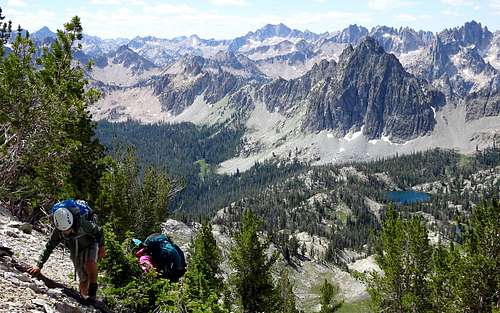
This day would be the crux of our Sawtooth journey, and it did not disappoint. From Crazy Eight Lake we ascended directly to the southeast ridge of Mt. Limbert via a very steep slope of loose talus and bedrock. The views improved with every step, and we made quick time to the ridge. By this time even the kids agreed that they actually preferred direct steep ascents to long switch-backing trails. I silently reveled in this small win for mountaineering.
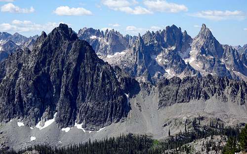
Sawteeth:
Looking toward the high pass between Mt. Carter and Mickey's spire, from the southeast ridge of Mt. Limbert:
From here we descended the loose but navigable slopes on the north side Limbert's ridge, then contoured around the head of the cirque on boulders and smaller talus, to the base of the next pass. At this point the ascent to the pass was only a few hundred vertical feet, but given its status as the high point of our loop and its fierce winds and bare rock, we dubbed it Badass Pass.
With clear weather and plenty of daylight, we took a little time to walk up to the summit of Mt. Carter--the fourth highest summit in the Sawtooths. More outstanding views, and we could see back to Alpine Peak where we started our journey.
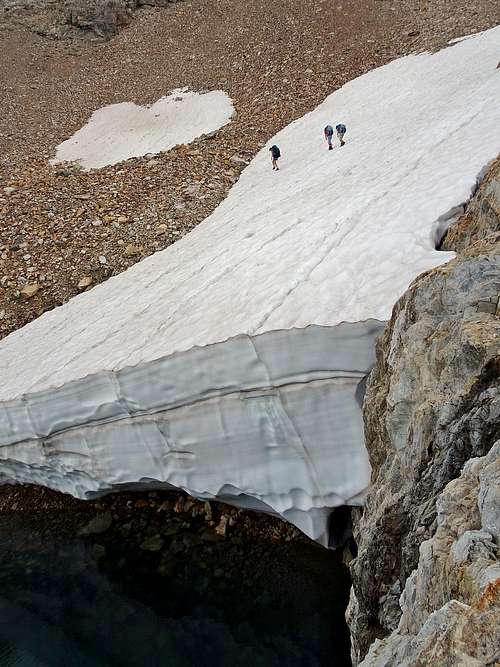
Back down on the pass we considered our options for descending into the upper Goat Lake drainage. From a few trip reports, photos, and satellite imagery, I knew it would be steep and likely snowy, and this information proved reliable. There was no snow-free route to the bottom, and the uppermost snowfields were exceptionally steep. Many of the run-outs emptied hazardously onto rocks, and most of the rocky slopes were too steep to descend directly. We were prepared to belay the children on accessory cord if necessary, but were fortunately able to find a reasonable route that required no belays and without any direct exposure to hazardous run outs on steep snow, so the cord and harnesses stayed in our packs.
We descended a steep and very loose rocky slope that accessed the snow fields relatively far down the slope. This was the steepest slope with the most loose rock we had yet navigated. I cleaned most of the major loose material as I descended first, and our tight grouping reduced the risk of anything picking up enough speed to be hazardous. Last but not least we wore our helmets.
At the bottom of the rock we found the snow steep, but well-softened in the day's heat. The run out was safe, but an unplanned ride down the slope would still likely result with some cuts and scrapes. Ice axes allowed us to safely walk the children down to lower angle slopes where we set them loose to glissade at will.
From here it was a pleasant stroll down suncupped snow and banded gneiss to the alpine heather and meltwater streams below Mt. Thomspon.
Thompson Camp:
Day 7:
The plan for day seven had included an ascent of Mt. Thompson via 3rd class scrambling on its west and south faces. After the previous day's scrambling and a summits however, there was not much enthusiasm for another alpine challenge. My own contentment with our secluded heathered terrain and reluctance to push the family one step too far left us with the obvious choice of kicking back and enjoying a day off. We explored the swales, and valleys, played a bit with the climbing gear, and I got my geo-kicks poking around at the metamorphic rock that was distinctly different from the granite in the core of the range.
We settled in for our last night in the Sawtooths.
Day 8:
It ain't over yet.
I had scouted a route down the uppermost Goat Lake drainage during our rest day. Immediately below our camp were cliffs and steep snow with worse run outs that those below Badass Pass. I had found what I thought was our best option via a short but steep patch of snow above rocks, that would probably require belays for the children. Trekking down to it on the morning of day eight found it hard and frozen in the cool morning. Definitely not ideal. Luckily, once at the snow we discovered a previously hidden route that followed an eroded andesite dike down and through a roofed descent on clean rock. From here the steep rock dumped into the navigable moat between the snow and the cliff face. The end of the moat required an exhilarating but safe climb over a small crag, and then down onto steep but stable talus and rock beside the snow. It was very safe and very fun, and made my morning.
Under the roof:
Through the moat:
Over the crag:
From here it was another pleasant stroll down subalpine meadows and past small lakes for a short time. From the lowest lake above Goat Lake, I had plotted a route that left the canyon to avoid possible exposed steep snow in the gorge directly above Goat Lake. In retrospect this was probably not necessary, but it was an uncertainty I wanted to avoid, and our chosen route worked well, regardless.
We made a short ascent to the ridge east and south of Goat Lake, where we skirted some snow above a small tarn. Not as scary as it looks, but still quite an epic crossing:
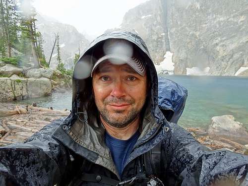
Just below the top of the ridge we picked up a faint trail that brought us down to the steep banks of Goat Lake. At this point we found other people for the first time in days, as well as thick black clouds that quickly turned to rain. We weren't going to get out of this final day dry. We scrambled around the surprisingly complicated and entertaining banks of the lake to the outlet. For some reason nobody wanted to stop for a family photo with me.
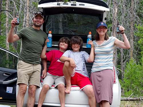
The steep decomposed granite slopes below Goat Lake were a piece of cake compared to what we had traveled during the last week, and in no time we were down on gently descending trail and soon back at the car for Gatorades and cool barley beverages.
Our week in the Sawtooths was enjoyably epic.
The solitude was well-appreciated and the rocky summits will leave a lasting impact on all of us. I intend to return to the upper Goat Lake drainage to bag that south face of Thompson before too long.
Thanks again for helping with our route planning.
I hope you enjoyed the trip report.
Ryan
South Jordan, Utah
July 2015
Just finished a short compilation of video footage that readers may enjoy:
Sawtooths 2015


Comments
Post a Comment