
-
 3824 Hits
-
 83.1% Score
-
 16 Votes
|
|
Mountain/Rock |
|---|---|
|
|
28.37914°N / 14.07709°W |
|
|
Hiking, Scrambling |
|
|
Spring, Summer, Fall, Winter |
|
|
2064 ft / 629 m |
|
|
Overview
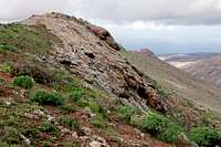
 Risco Blanco seen above the Peñitas Reservoir Risco Blanco seen above the Peñitas Reservoir |
On a volcanic desert island like Fuerteventura one usually expects lots of sand or lava with the occasional volcano piled up above. Also, you would expect arid conditions and greenery should grow elsewhere. Generally speaking Fuerteventura fulfils these expectations but go to the right place in the right time of the year and you may be surprised. The place is the Betancuria Massif, the second highest mountain range in the eastern centre of the island, a leftover of one of the giant volcanoes which piled up starting 20 million years ago but than collapsed in giant landslides which took them to oblivion. The right time of year is in winter, after a few days of the drizzling rains, which occasionally hit the island.
In general the Betancuria Range looks like a chain of hills, which enclose the former capital of Betancuria in their midst. Summits are round-topped, ridges are wide and saddles are only slightly pronounced. It is one of the most wonderful hiking areas of Fuerteventura but you rarely see anybody unless you get close to the roads which cross the range. In the west, however, between the village of Vega de Rio Palmas and the town of Pajara there is a rocky knife-edge, the Cuchillo de Ezquén.
 |  |  |
As knife-edges go, this Cuchillo is a rather blunt blade, one with bumps and saddles, a little more like a saw than a knife. Yet, for Fuerteventura proportions it is steep, rock and narrow. The ridge is made up from basalt which grows out of the softer surrounding volcanic material. With an accompanying ridge to the south it encloses Valle de los Granadillos, the most beautiful, though a little difficult ascent route. The valley combines with Valle de las Peñitas to form Barranco de las Peñitas, a short but very impressing canyon. The steep basalt walls which close in the canyon are the only climbing (?) and bouldering(!) places on the island.
Back to Cuchillo de Ezquén: The ridge consists of two parts: Risco Blanco in the west, which stands above the Grenadillos Valley and Risco de Carnicero in the east, where the highest summit, Pico Lima can be found. The western part requires climbing skills while the eastern part can be hiked. There are rumours of a hiking path which leads from Valle de los Grenadillos to the saddle between the two parts of the ridge but we weren't able to find it. Instead we had to scramble up the steep cactus infested slopes of the Cuchillo.
 |  |  |
Cuchillo de Ezquén can be considered the west ridge of Gran Montaña, the second highest mountain of the Betancuria Range. A climb to the Cuchillo will almost always end in a hike to the higher mountain. From there, by descending the far side to Morro Jorjado and Degollada Pechillera you can hike a long loop to or through Vega de Rio Palmas. This loop can be extended at will by including two or even three of the mountaintops north of Gran Montaña. The whole traverse offers excellent views across the island.
360° Summit Panorama
  |
Getting There
 Barranco de las Peñitas
Though there are ferries from the Spanish mainland to the Canary Islands, they take more than 24h for the trip. Therefore almost all visitors go by plane. Every travel agency in Europe offers flights, hotel rooms, apartments, rental cars etc. so that reaching the Canaries is rather a matter of money than opportunity. During the summer season flight fares can be reasonable but during the Easter and Christmas holidays you have to be prepared for additional fees of 500€ per person.
Fuerteventura has its own airport south of the capital Puerto del Rosario close to the center of the island. There are public bus lines but – like on all the islands – they don't run too regularly. If you plan to stay on your own, better take a rental car right at the airport.
The best starting point for Cuchillo de Ezquén is Vega de Rio Palmas in tits north though Pajara in the south is also possible. For the most beautiful ascent through the Barranco de las Peñitas you have to start at the hamlet of Buen Paso to the west. Pajara is seat of the municipality and connected by roads to the other two trailheads.
Pajara can be reached as follows:
- From the airport near Puerto del Rosario take FV-2 south
- Use FV-413 west to Antigua.
- Turn onto FV-20 south to Tuneje (alternative: take FV-30 to Betancuria and Vega de Rio Palmas, a beautiful mountain road)
- In Tuneje turn onto FV-30 to Pajara and Vega de Rio Palmas.
- For Buen Paso turn onto FV-605 in Pajara and one kilometre later turn onto FV-621 to Ajuy. A few km later a side road turns off right to Buen Paso.
- In La Oliva switch to FV-101 to Villaverde, where there is a small parking lot behind a bus stop to the right (east) of the road.
Red Tape
 Almond blossom with African Monarch
There's no red tape. However in Valle de los Granadillos there are lots of fields and gardens and the path vanishes among them. Respect the property. Also the old path from Vega de Rio Palmas to Degollada Pechillera has been closed due to the heavy erosion on the trail. You can still hike it (we did) but technically it is not allowed and you have to climb across cattle fences.
Accommodation
For holiday homes, hotels or apartments either consult your nearest travel office, or – search for lodgings on Google. There are several sites on the web, dedicated to rent privately owned houses or apartments. Prices are generally a bit less expensive than for tour operators but you don't have as much security.The Betancuria area has not (yet) been developed for tourism so that you won't find big hotels or apartment blocks in the area (though there are lots of souvenir shops). There are inns in the surrounding villages where you might be able to stay for the night. The closest holiday town is Caleta de Fuste on the east coast.
Weather Conditions
Fuerteventura is usually swept by fierce north-western trade winds. Though they deposit their humidity on almost all of the other Canary Islands, Fuerteventura (as well as Lanzarote is simply too low to form a decent obstacle. Therefore the climate is very arid. However, winds regularly are pretty strong, especially on the mountaintops. It pays to take warm wind-stopping clothes with you.For some time of the year, eastern winds prevail, which almost always carry clouds of Sahara dust with them. Usually this means reduced visibility but in some occasions "Kalima" occurs. Fierce storms take up the dust from the Sahara and sweep it across the islands. In these times visibility is nil and sometimes even airplanes have to be grounded.
Maps & Books
Maps
Regular Maps
- Fuerteventura
Kompass Map WK240
Kompass Verlag
1:50000
ISBN: 978-3-85491-174-6
Digital Maps
Kompass is the only company known to me which offers GPS digital Maps. In addition for those of you with Garmin GPS receivers there is a map source map set of all Canary islands out there.
- Fuerteventura
Kompass GPS4240
Kompass Verlag
ISBN: 978-3-85491-222-4
- Islas Canarias
Map Source custom map
By Manfred Pepper
downloadable zip-file
Books
My recommendation is a guidebook by Rother Verlag, available in German. The book is an excellent hiking guide covering all the interesting areas of the island. Since it comes with small maps for each excursion it might even be used without a map to support them.
- Fuerteventura
Rolf Goetz
Rother Verlag
ISBN 978-3-7633-4303-2