
-
 4306 Hits
-
 73.06% Score
-
 3 Votes
|
|
Route |
|---|---|
|
|
46.34130°N / 13.82030°E |
|
|
Hiking, Mountaineering, Scrambling |
|
|
Summer, Fall |
|
|
Most of a day |
|
|
Class 3 |
|
|
Easy climb |
|
|
Trail Heads

The most convenient trail head is the big parking lot at Planina Blato, 1147 m. The road till there is payable (20 € in 2023), but you can use also a free shuttle, losing of course some flexibility. Find time tables on the web.
Other possible trail heads are far more remote.
Approach - Lazovški preval, 1966 m
The summit ascent on Debeli vrh starts on the Lazovški preval (pass), 1966 m. It can be reached by good paths from three sides:
1. From the Laz alpine pasture, 1560 m, in good 1 h 15 min. This is the marked S-SW approach. The beautiful alpine meadow of Laz can be reached from the parking place on Planina Blato, 1088 m, in 1 h 30 min.
2. From the Velo polje (Vodnikov dom - hut, 1822 m), over the Mišeljski preval, 1995 m, in 2 h. This is the marked NE approach.
3. From the Krstenica alpine pasture, 1670 m, in 1 h 30 min. This is the non-marked SE approach. The beautiful alpine meadow of Krstenica can be reached from the parking place on Planina Blato, 1088 m, in 1 h 45 min.
All approaches are easy (T2 on the Swiss Hiking Scale) and the paths are well marked (except the approach #3, but also there we have enough cairns).
Route Description
The gradings of hiking difficulties are on the Swiss Hiking Scale.
Looking from Lazovški preval towards the northwest, to our mountain, we see steep rocky slopes and right of them a broad, flat karst slopes, leading to the high edge, NE of the summit. We can choose two approaches, on both we can now follow a weak path, but they are not marked and both require a safe step.
| See full screen |
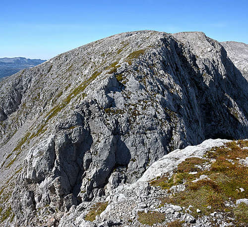
Variant 1. This variant uses a weak path, which can be clearly seen from the marked path on the Lazovški preval. It deters from the marked path just below the saddle, on the Laz side (so SW of the saddle). We first approach Debeli vrh bottom rocks, traverse a shallow valley and turning a bit to the left, scramble up where the passages are easiest. We can follow a weak path, which above, on the grassy shoulder/ridge becomes even stronger. The slopes are steep, so we must take care if it's wet or if we are ascending when on the slopes snow lies. Over the shoulder we soon reach the east ridge and the fore-summit. T3/T4. 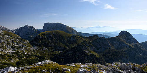
Approaching the high edge of slopes we keep more and more towards the left, where on scree slopes we see a good path, ascending steep to the east ridge of Debeli vrh. The ascent is unpleasant, but not too exposed (T3). |
Essential Gear
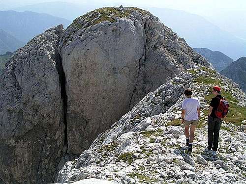
Good shoes, poles. For the notch traverse the rope is welcome, especially for less experienced hikers. In this case a short rope is enough, because there's only some 5 meters of climbing.