Introduction
Pictures
Setting the scene, WalksWithBlackFlies (Rich aka Rico) and I walked from St. Huberts to the base of Dix’ northern slides, setting up camp at about midnight on the 17th. We awoke at 6:30 a.m. and climbed the central Ring Finger Slide with a bushwhack of the ridge to the path and summit. We then descended to the South Fork Slide on the western side of the mountain. We planned to ascend/descend the new Irene slide on the southwestern buttress and then climb Hunters Pass Slide up to the ridge and walk back to camp…which we did, just later than planned. I’ll put up more on our route from August 18th later as well as adventures on the 19th and 20th.
The western buttress slide can clearly be seen from the trail to Hunters Pass and from Nippletop. It lies just south of Hunters Pass slide, ascending the steep buttress dissecting the western side of the mountain.
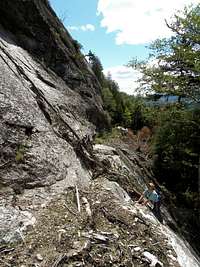
We’d just exited from a couple hours’ descent of the South Fork Slides, its drainage an extremely greasy endeavor requiring careful footing. We intersected the trail to Hunters Pass and walked on to the next target. I remember catching a glimpse of the great white giant through the trees and hearing Rico’s comment, “This might be one that we say, uh NO way!” I was secreting similar thoughts based on how steep it look, though the central portion looked realistic and I at least wanted to take a look. Above the center sat a near vertical looking strip that tapered to a point in the ledges just below the crest of the buttress.
Slide Proper
Passing the drainage from the Nippletop cirque, we soon found a break in the trees yielding a head-on view. They were intimidating and beautiful. The lowest portion a steep face leading to twin overhanging roofs with a piece missing in between like the mountain got in a fight and lost its front tooth. The missing “tooth”, some 50 or 60’ up, was about about 40’ long, 15’ wide and 10’ thick. Another shorter slide sat just to the north, separated by a strip of trees, but sharing the same foot-wall. It began with a shear slightly overhanging ledge.
![Kevin First Pitch Dix Buttress]() Kevin on the first pitch of the slide...it gets right to business.
Kevin on the first pitch of the slide...it gets right to business.
Before we could even approach the foot-wall, we had to cross a small stream into a field of ferns. A few hundred feet farther, we paralleled the debris field on the right. In the midst of the debris, we ate lunch and discussed strategy. We planned to leave our packs below, taking only ourselves, cameras and a bit of food/water. Our planned descent would be back down the slide…which didn’t work out, but more on that later. There’s no beta on this, so we planned to climb the lines that seemed most obvious, interesting and in the end safest. I kept looking up at the massive wall barring our way to the lower pitches of the lesser pitched stone. The most prominent line was between the roofs…this ended up being a technical route, I might add. I saw other small ramps leading toward the left side. WWBF was contemplating the same problem and working on the solution, if possible.
The first issue was the initial wall leading to a 4’ shelf part of the way up to the overhangs. Much of this was obviously exposed in the past since there was moss aplenty. Much was cleaned by the debris fall. Rico climbed a line up a near vertical wall. I took a route up a similarly steep, but cleaner, intrusion of basalt just to the right. In hindsight, there were easier routes just to the north. Once atop the shelf, I could feel Rico vibrating with excitement and studying the left-hand overhang. A crack along the dihedral some 12’ high seemed like a possible weakness. I was curious, but let Rico lead the exploration…I’d follow if the route was sound. The problem was one of friction. Minimal handholds, 45+ degree slab and sand/mud dotted the 25 or 30 feet of elevation to the crack. He gingerly made his way upward. A fall would not be pretty.
![Rich in Between Overhangs]() Rich in between the twin overhangs on the second pitch of the Buttress Slide. We did NOT free-climb this area in the end.
Rich in between the twin overhangs on the second pitch of the Buttress Slide. We did NOT free-climb this area in the end.
Once near the roof, he found the crack to be dirty and blocked with a tree trunk which he cleaned out. The route was also slightly overhanging…we’d not be going up this technical route. The adjacent dihedral to the south was in even worse condition. By now, I’d moved up the slab on the aforementioned ramp to take pictures as he carefully down-climbed. He hadn’t memorized the holds so the next 10 minutes were tense while I watched him search for nubs in the face and wipe debris from underfoot. So the lesson…DON’T go up between the roofs without protection.
With the tension gone, we could now behold what the area offered. These massive overhangs connected to the face were pieces of God’s art in my mind. Striated edges added dimension as they seemingly swallowed the view south when underneath them. Perspective changed their appearance every step of the way. We still planned to climb Hunters Pass Slide, but even its incredible swath would have a hard time surpassing what this offered.
![Kevin on the Crux of the Slide]() Kevin nearing the crux at the upper dihedral. A crack added security and much interest to the area.
Kevin nearing the crux at the upper dihedral. A crack added security and much interest to the area.
Rico worked over to me as his adrenalin abated and we climbed to the far left-hand side of the roof, I first. There was a precarious pile of stones near enough to climb. I tested them and they seemed stable, but warned Rico to move to the side in case they fell. Finger holds, an under-hand maneuver and using the back of my neck against a joint in the roof finally gave me the leverage I needed to overcome the obstacle. Another less precipitous, but friction based climb led up another rounded ledge. Rico followed and we sat stunned, looking up at the swath of white anorthosite that led up to multiple pitches of more extremely steep climbing.
To our right sat a house sized chunk of stone, part of the mountain and unmoved by the event. Below was nothing but air. Relaxing from our climb, we turned to survey the Nippletop cirque, deeply inset into the mountain, a rare view. It can be seen from the path, but it’s more dramatic from a head-on perspective. It’s home to a new rubble slide and new rock falls on it’s northern cliffs.
Climbing the lowest portion was typical friction climbing on moderate pitched stone. Soaking in the scenery and magnitude of the event was the primary task. Leftover mud and rubble was present as usual on new slides. A comparison to Wright’s 2011 slide jumped to mind, the pitch and scattering of debris was similar.
The first of the two major top pitches changed the climb dramatically. The obvious line was up a fracture in the center of steep rolling ledge sets. The stone to the right seemed like the most conservative route, but I wanted to explore the center and its holds. The climb required out all the tricks that I know. Had it been clean, this might not have been the case, but it was a bit dirty in all the wrong (read precarious) places. Only nubs of feldspar kept me in place at times where the fracture was too filled with mud to be useful. Gasping for breath at the top, I sat on a boulder and watched Rico climb from far below. He chose the stone to the right and made it up in half my time.
A few more ledges led to the crux of the upper slide…a crack climb with good friction and hand-holds along a dihedral. My thoughts were singular, however…be one with the stone. The pitch was minimally 45 degrees for 50’ or so. Atop the crack where it intersected with the next pitch, I used undercling holds to work around more…yup, mud. Once again feeling like my a** was hanging out in thin air, I was happy to be on clean if not steep rock. I could see the final feet of the slide ending in as point just around a dominant overhanging boulder. The friction was good as I worked close to the feature, the stone falling away to my left. I waited for Rico at the top, sheltered under an 8’ roof of stone with Nippletop peeking through the gap. We were all smiles at the top of this most challenging climb. It pushed many of my limits and even some of Rico’s who is more comfortable on steep exposure than I.
Exit
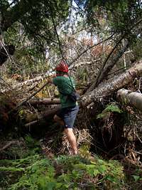
The original plan was to descend down the slide to our packs. Once atop the slide, this thought evaporated…it was just too steep to safely down-climb. Hunters Pass Slide was close to the north, but there were ledges and cliffs galore in that direction. A vegetation descent along the south side, might have been possible. Rico expressed a different idea that I’d considered months ago…climb up and over the buttress and bushwhack to the drainage of the North Fork Slide. We put the plan into motion.
![Top of Dix SW Buttress]() Rich managing a route through the heavy blowdown atop Dix' SW buttress. It got worse after this pic.
Rich managing a route through the heavy blowdown atop Dix' SW buttress. It got worse after this pic.
The climb to the top was through a mess of blowdown, but since the slide nearly reaches the top, it was not a problem. The portion thereafter was…”interesting”. As mentioned, our packs were at the base of the slide…poor planning as our shoes were in the pack as well. The next mile long bushwhack would be done in rock climbing shoes…painful to say the least as they jam the toes in an already minimal toe box. Traction is non-existent in duff or wet wood.
Ledge upon ledge intercepted our SSW route to the drainage. Some were only 6’ high, others were minor cliffs. Thankfully each had a weakness at one end or another. The woods were quite thick and ancient blowdown plentiful. About ½ hour later we reached the drainage. Ten minutes later, we reached the intersection with the South Fork Slide at 3200’ where we’d been hours earlier. I shot Rico a sly glance and quipped something about seeing this earlier. We’d already trodden the remaining descent of 600 or 700’ feet to Hunters Pass trail and didn’t look forward to the second round. Arriving at our packs at about 5 pm, we breathed a sigh of relief as we put on trail runners and began the short trek to Hunters Pass Slide for the next climb of the day.
Overall Route of 2012 August 18
The following picture encapsulates the overall route of the day. Total route mileage was about 6 miles of bushwhacking, 5000 feet of elevation gain over about 13 hours. The red line corresponds to the slide detailed above.


Comments
Post a Comment