
|
|
Route |
|---|---|
|
|
34.11770°N / 116.85599°W |
|
|
Hiking, Mountaineering |
|
|
Spring, Summer, Fall, Winter |
|
|
One to two days |
|
|
Class 3 |
|
|
Basic Snow Climb |
|
|
Overview

Climbing Dollar Couloir

Great Views
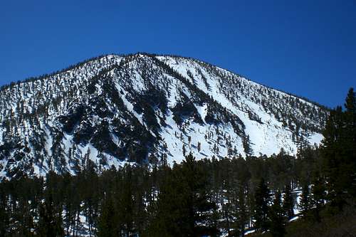
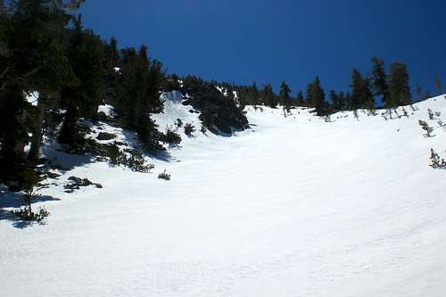
Dollar Couloir is a couloirlocated on the north face of Charlton Peak, in the San Bernardino Mountain. Dollar Couloir begins just above Dollar Lake (the namesake for this route). Camping can be done at this lake, however, you should avoid camping in this vicinity with unstable snow higher up. The couloir starts at around 9,450ft and then tops out at half a mile later at about 10,700, just shy of the summit of Charlton Peak at 10,806ft. The summit is just a short hike after the climb. This route is a pretty straightforward snow climb. The couloir is very wide in most places and is only narrow in one spot. The average angle for the route is probably 35 degrees with a max of around 41 degrees at around 9,990ft. Aside from being an excellent snow climb, the views off this route are amazing. You have views of the northern half of the "9 peaks" along with views of Big Bear Lake and much more of the San Bernardino Mountains. This route can dayhiked (its a long day that way), however, some may prefer to move more slowly and do a two day climb.
The route is obvious when approaching it on the Dollar Lake Trail. The North Face of Charlton looms in front and there is a visible scar in the direct center- this is Dollar Couloir. Dollar Couloir is just under a half mile long, but gains around 1,300ft of elevation.
Approaching Charlton Peak
Route Description
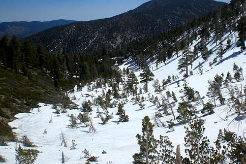
The easist way to access this route if from the South Fork Trail. You follow the South Fork Trail for 4.6 miles until you reach the Dollar Lake Trail split. This first part you gain about 1500ft of elevation. From here, follow the Dollar Lake Trail. You follow this trail for 1.8 miles and then you reach Dollar Lake. Another 1200ft of elevation is gained here. From the last part of the Dollar Lake Trail, you will see the route.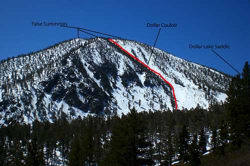
The Route
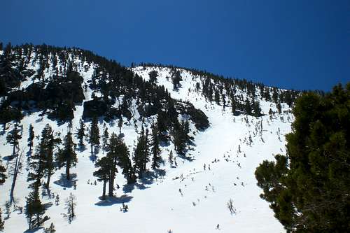
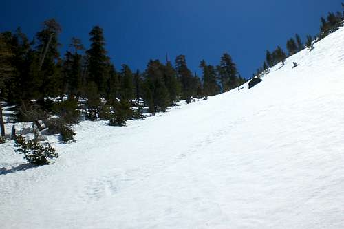
Right add the Dollar Lake Trail split, begin heading south off trail towards a avalanche carved gully just above Dollar Lake. The trees here are sparse due to avalanches that rip through during winter. I think it was 2005 when a huge avalanche that initiated on this same couloir ripped down through Dollar Lake and past it. Be aware of snow conditions while on this route! The angle of the slope gradually starts to increase as you get higher up. The start of the couloir is around 30 degrees.
Flagged trees, evidence of avalance activity
At the base of the Couloir
Looking Up
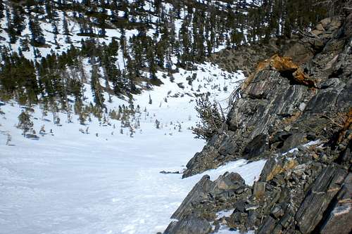
At about 9,800ft, the couloir narrows alot and the angle goes up to around 41 degress. Without snow or with little amounts, this part is very rocky. However, when snow fills it up, it is easily bypassed. This whole couloir is treeless. However, there are trees along the outer parts, but these are puny at best...Once again, a result of avalanches.
Looking Down
The route angle the lowers to around 35 degrees and continues to decrease until the top. While going up the couloir, you think that the summit is in sight. However, these are false summits. At around 10,650ft, the couloir loses shape and you reach the broad summit of Charlton Peak. Head south to reach the true summit.
Nearing the top
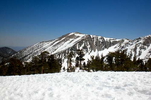
Rewarding Summit View
Dollar Couloir:
Elevation Gain: 1,400ft
Mileage:.50 miles
Overall:
Elevation Gain: 4,000ft
Mileage (Roundtrip) 14 miles
Getting There
From Redlands-From interstate 10 at Redlands exit Highway 38/Orange Stree and drive northeast. Continue past the Forest Falls turn-off through the town of Angelus Oaks. Turn right on Jenks Lake Road just beyond a large parking area on the shoulder. The large trailhead parking area is on the left and right hand side of the road. Park here and begin the hike.
Essential Gear

Taking a Break
Since this page is set up to be a snow climb, helmet (which would be recommended even without snow), crampons, ice axe, trekking poles, warm clothes, sun protection, skis (for those who want to ski this route down) and a good pair of hiking boots. Also, bring lots of water for late season attempts on this route.
External Links
San Bernardino National ForestSan Gorgonio Ranger Station
34701 Mill Creek Road
Mentone, CA 92359
San Bernardino National Forest
San Bernardino National Forest Website
San Gorgonio Wilderness Association
A website devoted to the San Gorgonio Wilderness Area with lots of information.
San Gorgonio Backcountry Board
A great place to find current conditions and recent trip reports about the area.
Charlton Peak Weather Forecast
The current weather conditions for Charlton Peak
Deb - May 16, 2011 10:37 am - Voted 10/10
AngleI've got to say that I didn't find anything over 35-40 degrees at the steepest in this couloir. Kinda bummed cuz I sure wanted to do something steeper. Sorry, folks - Jepson's got the steep stuff!
Alex Wood - May 16, 2011 4:18 pm - Hasn't voted
Re: AngleSo what would you say the max angle you found was? Looking back, I can definitely say its not 50 degrees haha.
Deb - May 19, 2011 5:57 pm - Voted 10/10
Re: AngleIf I HAD to give a single number, it would be 37 degrees. I know when I hit 40 cuz I am ready to climb on all 4s. HA! Beautiful climb though, loved every huff'n puff step whilst getting snow on. :)
Alex Wood - May 23, 2011 3:24 am - Hasn't voted
Re: Angleokay sweet, I will update it to that. Glad you liked the route!
Elanski - Apr 15, 2013 5:22 pm - Hasn't voted
Re: AngleHi there, you never updated the steepest pitch on Dollar couloir. I climbed it 4/14/13 for the second time, and at the top of Charlton some one asked me about the steepness and that on SP it says 50 degrees max. For the second time I measured with a clinometer and it is at the very most 40-41 degrees at the steepest parts, which are very short. The majority is around 35-36. Last year Deb and I climbed it on rather firm snow w/o crampons or ax in AT boots and approach shoes. Yeah a bit sketchy but doable if you're careful and conditions are not bullet proof.
Alex Wood - Nov 13, 2013 5:17 pm - Hasn't voted
Re: AngleElanski, Thanks for the comment! I updated the pitch. Turns out there were two place where I had said the couloir was 50 degrees and I had only changed one. Thanks for the feedback!
tony bird - Apr 22, 2013 4:53 pm - Hasn't voted
silly snowclimberssilly snowclimbers, couloirs are for skiing. i think this is a, if not THE, perfect couloir. if it were next to a road, every skier in southern california would be on it. i skied it 4-11 and 4-21, the latter under perfect spring corn conditions, and i looked like a real skier for once in my life. i was even able to link some turns in the 25-foot narrows. try to hit it early afternoon. booting up was a breeze on 4-21. on 4-11, i started breaking through, so i had to use skins from the midway point. it's an exhausting day doing this, but thoroughly rewarding. i noticed a north-trending couloir on charlton which also has good potential. anybody done that one? i think charlton got more snow this year than any mountain south of shasta, and dollar couloir ought to be skiable for at least a couple more weeks to come. there's probably about a mile of skiing from the summit, which i did with alfred on 4-21. (only did the main part of the couloir, solo, on 4-11.) there are distinct divisions--a small "micro" bowl at the top; the upper couloir, about 40 degrees; a central part of lower angle; a third section, narrower and steeper; and then the avvy runout, which goes at about 25 degrees and had wonderfully soft crud. if you cut north as soon as possible, you find some further, pleasant runs all the way to dollar lake, which is nearly dry, but had a couple of hopeful mallards in one of its puddles.
Alex Wood - Nov 13, 2013 5:18 pm - Hasn't voted
Re: silly snowclimbersHey thanks for the comment Tony! I have yet to ski, but maybe I can this winter! I was not a skier back then... Happy travels!