
-
 14317 Hits
-
 81.84% Score
-
 14 Votes
|
|
Mountain/Rock |
|---|---|
|
|
48.08570°N / 9.03870°E |
|
|
2690 ft / 820 m |
|
|
In Memory of Stefan "kletterwebbi" Weber
 A note from the SP staff
Stefan Weber, the member we all used to know from his climbing pseudonym kletterwebbi, died on May 28th 2004 in southern France at the age of 37.
Stefan joined SP early on in 2002 and contributed a number of excellent pages and routes to this site. He was an accomplished climber excelling in difficult alpine and technical routes. The Dolomites, especially the area around Gröden / Val Gardena were special to him, as it was his old ancestral home.
kletterwebbi was always willing to share his knowledge and experience with other climbers, mainly here on SP, but also on other sites. He contributed his IT expertise as webmaster of his local section of the German Alpine Club, where he also engaged in leading trips for fellow members. Besides his climbing and mountaineering activities he was a musician, a composer of contemporary music. Stefan will be greatly missed by us all.
This page will be kept in honor of kletterwebbi, one of SP's most talented, knowledgeable members, and without a doubt, one of our greatest fellow mountaineers.
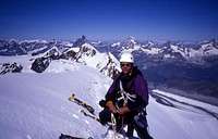
The picture was taken on the summit ridge of Lyskamm.
Overview
The climbing area of the Donautal (danube valley) is located in the SW of Germany in central europe about 120 km south of Stuttgart (capital of the federal state Baden Würthemberg). You find the climbing-relevant part of the valley between the towns of Tuttlingen and Sigmaringen.The Donautal (Valley of Danube) is one of the best (and even biggest) climbing regions of germany (hey guys from the Frankenjura, that's true !!!). Beside the closures of the last years, there are still enough climbs for many, many days.
Rock type and quality
Like most of the south german climbing areas, the Donautal consits of limestone. The climbs normally are very technical, mr. monster will get some problems. You will need to use one or two of your feet to reach the top. In most climbs there are some tricky moves. Many routes have two or more pitches. Concerning this, the hightlight of all climbs is the Kaiserweg at the Schaufelsen with five (!) piches, known as the longest non-alpine climbing route of germany.
The limestone of Donautal normally is quite good, in some areas even excellent. But there are also some loose rock areas. If you want to climb the higher rocks like Schaufelsen you should use a helmet.
Protection, type of climbing and rating
Most climbs of the Donautal and Zollernalb are very well bolt protected. But the distance between the bolts in some routes may force the use of nuts to protect one or two moves. It´s difficult to use Friends. Especially some of the classic climbs need a medium to full rack. The modern sport climbs normally don´t need nuts. There are some real good but very free climbs, go for it !
The rating uses the UIAA grades. Most climbs need at least the sixt UIAA grade (5.9/5.10a), but below there are a lot of good posibilities too. Remember that fully bolted routes are a different proposition to routes on which you have to place gear.
 |  |  |  |  |
Getting There
The central place to start climbing activities at the Donautal for most people is the small village of Hausen im Tal below the Hausener Zinnen. It's a kind of capital for the Donautal, the main approach roads are joining in Hausen, most of the climbers pubs can be found there. The easiest way to reach Hausen im Tal is to use a car. An other good possibilitie is the train.By train
One of the main german train lines from Freiburg to Ulm leads trough the Donautal. So it's easy to reach the valley by train. You can reach this line from all citys in germany.
By car
The best way to reach the Donautal by car is to travel to one of the towns Tuttlingen (west of the valley) or Sigmaringen (east fo the valley). From both towns you can reach the climbing region easyly. Sigmaringen is located at the east border of the climbing area, Tuttlingen at the west. Just follow the roads signed "Donautal".
There are also possibilities to reach the valley from north (e.g. Tübingen) via the B27 to Albstadt and from there direct to the valley.
From the south (e.g. arriving from Lake of Konstanz) travel to Messkirch and from there to Hausen im Tal.
Red Tape
The whole Donautal is a nature reservation, climbing is prohibited in general. The allowed climbs/rocks are exceptions from that fact. The local climbing community was living in a long, sinewy struggle with the administration over the last years. But now we've found a way to live together - climbing and conservation.So please:
Respect the closures to prevent any more restrictions !
A actual list of the allowed rocks can be found at the homepage of the IG Klettern Donautal or at the rock list of the DAV.
Projekt Schaufelsen
Actually the so called "Projekt Schaufelsen" will be released. This will re-open about 100 routes at the Schaufelsen and Blicklefels and the close-by "Hölle".
When To Climb
The common time to climb at the Donautal are the months may to september/october. But it's often possible to climb in winter (a good place is e.g. Schreyfels), and some of the local climbers celebrate an anual christmas-climbing.Camping
There are a lot of possibilities to pass the night. Beside the different Hotels in the valley there is the Ebinger Haus of the DAV Sektion Ebingen (Phone: +49 - 7431 - 3480) below the Stuhlfelsens and the "Naturfreundehaus" in Stetten (Phone: +49 - 7573 - 2591). Those are kinds of huts, they are simple but ok.There is also the campground "Campingplatz Wagenburg" in Hausen im Tal (Phone: +49 - 7579 - 559).
Mountain Conditions
Use the according entrys from Wetter Online to check the conditions at Sigmaringen or Tuttlingen.Rocks and routes overview
To list all routes of the Donautal would exceed this page. Instead of this take a look at the following, brief overview of the rocks of the Donautal:- Schreyfels, a high, demanding rock, most routes about UIAA grade 6/7
- Dachstein, one of the steepest rocks of the valley, good routes about UIAA grade 7
- Stuhlfels, a lot of easy routes, on of the best rocks for beginners
- Parkplatzfels, the high end rock of the valley, most routes above UIAA grade 8
- Verlobungsfels, an other good rock for beginners, a little poolished, but who cares ...
- Garmischer Turm, a nice, little thing, not so easy (UIAA grade 7)
- Löchlesfels, if you put one hole at the other you get the Löchlesfels, very good rock, main part about UIAA grade 7
- Fuchsfels, one of the climbing highlights of the Donautal, good in summer (shadow), good routes above UIAA grade 6
- Westliche Zinne, one of the hardest rocks in the valley, only routes above 7+
- Erste Zinne, some demanding, difficult routes, steep (> UIAA grade 6)
- Zweite Zinne, like the Dritte Zinne one of the best climbing possibilities of the valley.
- Dritte Zinne, superb climbing area, routes from UIAA grade 4 to 10
- Fischerfels, a nice, little rock with routes of all difficulties
- Bergwachtfels, small rock but some few nice routes
- Hausener Wand, some classic routes about UIAA grade 5, sometimes somewhat crowded
- Eigerturm, like at the Hausener Wand there are mainly routes about UIAA grade 5 and 6, sometime many people
- Traumfels, a dream ... good climbs, shadow, ... UIAA grade 4 to 9
- Hölle, Steep, overhanging, maximum power, difficult ... any more questions ? UIAA grade 5 to 9, mainly 8 and 9
- Schaufels, many think this is the best rock at the valley, long, demanding routes from UIAA grade 5 to 9, 150 m hight !
- Blicklefels, the smaller brother of the Schaufels, very good routes at UIAA grade 6
- Falkenwand, many climbs from UIAA grade 5 to 9, good with childs
- Bad Men Rock, for bad people, routes of UIAA grade 9 and 10
- Rabenwand, a fantastic rock, but mainly difficult (> UIAA grade 6)
- Donaucalanque, a kind of south french climbing feeling, a river, bolts, ... hmmmmm
- Aussichtsfels, some interesting routes for beginners, easy approach
- Dreiecksfels, some good routes but also some routes with poor rock quality
Over all there are more than 500 routes waiting to be climbed.
 |  |  |  |  |
Historic pictures
The climbing history of the Donautal starts at the beginning of the 20'st century. Here are some historic pictures from the Däle (source of all pictures: DAV Panorama, Dec. 2002) |  |  |  |
Guide book
Kletterführer schwäbische Alb, Band 3, Panico Alpinverlag (german language only).Projekt Schaufelsen
A project group of DAV and conservation groups have worked to find a climbing arrangement which fits the concerns of conservation and climbers. The soultion is provided by the so called Schaufelsenprojekt.The different sectors of the Schaufelsen will be adopted by different climbing groups (DAV Sektion Tuttlingen, DAV Sektion Ebingen and IG Klettern Donautal).
External Links
- IG Klettern Donautal
The Homepage of the IG Klettern Donautal (IG means a group with the same interests). A lot of informations about the Donautal, german only.
- Alpenverein Badenwürttemberg
- DAV Sektion Ebingen
The maintainer of the Ebinger Haus in the valley.
- DAV Sektion Tuttlingen
Homepage of the section Tuttlingen of the DAV, this contains Donautal pages in german and english.
- Rock list south germany
The official list of all the rocks which are allowed to be climbed. German language only.
- Projekt Schaufelsen
All informations about the "Projekt Schaufelsen". This project - a corporate initiative of climbers and conservation - has re-opened many climbs (about 100 routes) at the Schaufelsen-area.
- Projekt Schaufelsen
Flyer about the "project Schaufelsen". This project is a cooperation between climbing organisations and cconservation.
desainme - Jul 3, 2005 12:17 pm - Voted 10/10
Untitled CommentAccording to a Microsoft atlas,
Tuttlingen is located:
Latitude: 47.99 N
Longitude: 8.8E
It is nicely shown on via Michelin but how to make that atlas yield longitude and latitude?