
-
 3592 Hits
-
 80.83% Score
-
 13 Votes
|
|
Mountain/Rock |
|---|---|
|
|
49.13464°N / 7.83123°E |
|
|
Trad Climbing, Sport Climbing, Toprope |
|
|
Spring, Summer, Fall |
|
|
1050 ft / 320 m |
|
|
Overview
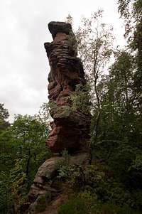
 Ostgipfel South Face Ostgipfel South Face |
The village of Busenberg in the Südpfalz Areais surrounded by sandstone formations from all sides. While this is nothing unusual in the region there are few villages where this is more evident than here. The village itself is cradled between a ring of hill-like mountains, all of which sport at least one sandstone formation near the tops of their crests. To the north, on Eichelsberg this becomes most evident.
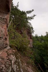
Right above the village a long but rather low crest of sandstone cliffs can be seen, which separates into the slightly separated Kreuzfels and a formation of three towers: Drei Steine. The literal translation is "Three Stones" and while this might seem an uninspired name this is actually exactly what you find here. The south faces, which tower above Busenberg, are freely accessible by a nature trail. Thanks to their broad rocky base the forest retreats from the rocks by about 100m, making the south faces good places to climb on cold but sunny winter days. The north faces are different. Here the trees touch the rocks which gives rise to a lot of moss and other greenery.
 |  |  |  |
Consequently almost all of the routes have been established on the south face while there is only one real north face route plus a few ledge routes, generally attributed to the same face. Like all of the other Busenberg routes the ones on Drei Steine are fairly new. While in the remainder of the area the important routes were created in the first two decades of the 20th century, here the first records name the early and mid 1960s. The usual suspects pioneered them, Hans Laub and Rainer Braun, as well as guidebook author Udo Daigger. The latter, with Erich Wittmer created the only north face route "MG-Nordwand" in 1959.
 |  |  |  |
Today climbing activity has drifted on to the Buhlsteine Cliffs, which can be found to the east of Busenberg. Also Heidenpfeiler to the south-east, the talles Südpfalz tower attracts mor attention.
Climbing Routes on Drei Steine
 Westgipfel South Face
The following table has a link to the tour database of the PK, where you can find the grades for the free routes plus additional information. Here is the link to the complete route database.
The size of this table stands in stark contrast to the importance of the tower. The number of documented routes speaks a different language. There are 84 routes, which are described in the climbing guidebook and no doubt many more, especially variations have been established without the knowledge of the authors.
Like most of the rocks around Busenberg Drei Steine saw their first ascents only in the early 1960s. The normal routes to the three rocks might have been climbed earlier but there are no records. As usual Hans Laub established many of the routes, also Raine Braun, sometimes together as a party. The most difficult routes were created by Oliver Jacob, Hannes Humburger, Helge Grey and Thomas Simon across all three rocks in 1994. Most routes can be found on the south face of the formations while the north face is home only to a handful of routes.
| Feature | Routes link | Summary |
| Drei Steine Ostgipfel | Eastern Summit | 7 routes ranging from 2 - 7 |
| Drei Steine Mittelgipfel | Central Summit | 6 routes with variations ranging from 2 - 7 |
| Drei Steine Westgipfel | Western Summit | 12 routes with variations ranging from 1 - 7+ |
Getting There
 Mittelgipfel South Face
A good starting point for the rocks which are located to the north of Busenberg is the village's sports field. From there a marked nature trail leads to Drei Steine and Kreuzfels. You can reach Busenberg as follows:
From Frankfurt
There are two possible routes which both take equally long- Via Ludwigshafen
- From Frankfurt take motorway A5 southward to Darmstadt.
- There change to A67 south.
- At Viernheimer Dreieck turn onto A6 west. Leav
- e it at Frankenthaler Kreuz for A61 south.
- At Mutterstädter Kreuz take A65 south until you reach Landau.
- At Landau turn on B10 west.
- At Hinterweidental turn onto B427 south which will take you through Dahn to Busenberg
- Via Kaiserslautern
- From Frankfurt take motorway A3 west
- At Mönchhofdreieck turn onto A67 south
- At Rüsselsheimer Dreieck take A60 west
- At Kreuz Mainz Süd take A63 south
- At Kreuz Kaiserslautern turn onto A6 west
- At Kreuz Landstuhl turn onto A62 south
- At Pirmasens turn onto B10 east
- At Hinterweidental take B427 south to Busenberg
From Stuttgart
- Take motorway A8 to Karlsruhe
- At Karlsruher Dreieck turn north onto A5
- Tke the next exit to head for A65
- At Kandel you can leave onto B427 which will lead you directly to Busenberg.
Red Tape
The sandstone of Südpfalz forms lots of caves and overhangs. Though this makes it most interesting for climbers, two species of birds of prey compete for this habitat: the peregrine falcons and the eagle owls. Both are endangered and wherever there is a eagle owl pair found nesting in the sandstone the crag will immediately be closed. Generally this closure lasts from the beginning of each year through Aug. 1st. If breeding is not successful the closures will be canceled even before that date. For a list of closures see the Closure List of PK.The use of magnesia is not allowed in the whole Südpfalz region. This is rather a directive or an arrangement than an outright law. Thus you probably will get away with using it but do so only when absolutely necessary. Magnesia closes the pores which you find in the sandstone and together they form a smooth surface which will get very slippery in wet conditions. The rule of thumb is to use magnesia in the highest difficulty sections and only extremely sparingly.
A list of guidelines can be found here (in German).
Accommodation
In Busenberg you can find pensions, apartments and restaurants. Have a look at the official site for more info. There is a campground at Neudahner Weiher, north of Dahn, a second one west of Dahn. Both are about 10 km to the north-west of Busenberg. A third campground can be found at Bruchweiler-Bärenbach, about 7km to the south-west.Weather Conditions
Maps & Books
Maps
As for maps there is a good overview map (1:50000) by Kompass Verlag but the best ones are the official topographic maps by the state government of Rheinland Pfalz, scaled 1:50000, 1:25000 and 1:5000. All official maps can be found on the web page of Landesvermessungsamt Rheinland Pfalz
1:50000
- Naturpark Pfälzer Wald
Kompass Map WK766
ISBN: 3-85491-523-3
- Pirmasens Süd
LVA RLP Map L6910
ISBN: 3-89637-193-2
1:25000
- Dahn
LVA RLP Map 6812
ISBN: 3-89637-147-9
Books
There are a number of climbing guidebooks on the region of Südpfalz. The best ones, however, have been published privately and are sold only in selected bookshops of the region.
- Hiking
- Pfälzerwald
B. & J.-Th. Titz
Rother Verlag
ISBN: 3-7633-4268-0 - Klettern im Buntsandstein
U. Daigger, H.-J. Cron
Westpfälzische Verlagsdruckerei St. Ingbert
ISBN: 3-00-0155457-4
- Pfalz - Klettern im Buntsandstein des Pfälzer Felsenlands
J. Richter, S. Tittel
Panico Alpinverlag
ISBN: 978-3-936740-41-7
- Pfalz ++, Klettern im Buntsandstein
R. Burkard, P. Weinrich
Published privately
- Klettern im Naturpark Pfälzerwald
Naturfreunde Lambrecht
Published privately - Pfalz & Nordvogesen en bloc
A. Wenner, Y. Corby, I. Bald
Panico Verlag
ISBN: 3-936740-19-4
  Climbing Guidebook |
Climbing