
|
|
Mountain/Rock |
|---|---|
|
|
39.08058°N / 119.87801°W |
|
|
Douglas |
|
|
Hiking |
|
|
Spring, Summer, Fall, Winter |
|
|
8658 ft / 2639 m |
|
|
Overview
Duane Bliss Peak is located in the Toiyabe National Forest in the mountains east of Lake Tahoe. It is part of the Carson Range. It is accessible off the Tahoe Rim Trail via a steep bushwhack, and requires about three and a half miles of hiking to reach the summit. Despite its accessibility, visitors are infrequent, and it does not even have a dedicated trail to its summit. Despite these setbacks, Duane Bliss Peak is highly recommended. It can be hiked in 2 1/2 to 3 1/2 hours.Views from the summit are outstanding. Lake Tahoe can be viewed in all its glory. There are excellent views to nearby mountains, including Snow Valley Peak, Mount Rose, Relay Peak, and Mount Houghton to the north, Genoa Peak and South Camp Peak to the south, and to the west are views of Mount Tallac, Dicks Peak, and the mountains on the west side of Lake Tahoe. In addition, there are stellar views east to the valley below and of the Pine Nut Mountains of Nevada.
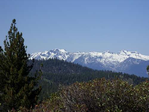
Mount Tallac 9735' and Dicks Peak 9974' from Duane Bliss Peak
The mountain can be hiked during most of the year, but the best time is probably is in the fall (late September, October, November) or late spring (late May/early June) when much of the snow has melted, but it isn't too hot or overgrown.
The Peak is named after Duane L. Bliss (1833-1907). Bliss was a successful businessman in Northern Nevada who was instrumental in the early efforts at increasing tourism in Lake Tahoe. In 1893, he founded the “Lake Tahoe Transportation Company”, formed to build a rail line to carry tourists to Lake Tahoe.
Getting There
If coming from the Reno-Carson City area, take U.S. Highway 50 west to Spooner Summit. Spooner Summit is a trailhead with parking on both sides of U.S. Highway 50. For Duane Bliss Peak, the parking area is on the south side of Highway 50. There are parking spaces on the south side of the highway, with additional spaces below, closer to the trailhead. The elevation here is 7150 feet.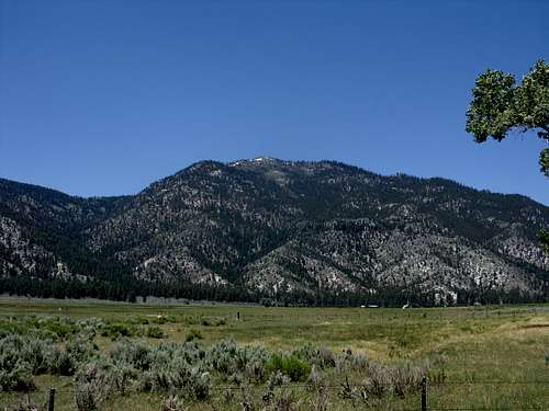
View of Duane Bliss Peak from Jacks Valley, 3600 feet below.
Route
From the parking area, head straight towards the Tahoe Rim Trail (TRT). The well maintained trail winds up for a little over two miles where it starts heading towards Duane Bliss Peak. A dirt road crosses the TRT around this point. Continue up the trail. Soon you will be in a selectively logged forest. The decision has to be made about when to head up to Duane Bliss Peak. There is no off-shoot trail. The terrain is pretty steep.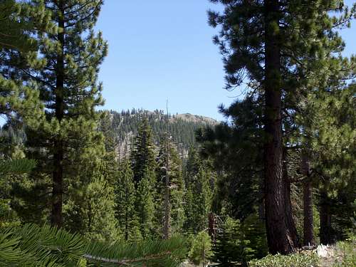
View of Duane Bliss Peak from the Tahoe Rim Trail.
The best place to head up Duane Bliss is when you are at the base of the south end of the mountain. The elevation here is about 7950'. An unmaintained, and overgrown road forks left from the Tahoe Rim Trail. Take this road for less than a hundred yards where it fades out. Head back (north) up the mountain. This is more or less a bushwhack. However, the trees and brush aren't very thick. Head up the steep slope where you will reach a small hilltop in the middle of the forest. From the hilltop, another unmaintained, overgrown road comes into view back to the north. Head north up this road. After a few minutes you will see the open summit area above the trees. Head up towards it where you will reach the false summit. The true summit is only a couple yards ahead heading south.
The total distance (one way) to the summit is about 3 1/2 miles, with an elevation gain of just over 1500 feet.
If you want a loop hike, you can descend via the forest road. The TRT crosses the forest road on the way back from Duane Bliss Peak, and you see a gate below. This is a little over 2 miles from the trailhead from the TRT. Take the road as it winds down, steeply at times. It then curves around and heads west, parallel to US 50. It is similar distance back to the trailhead as the TRT.
Red Tape
There is no red tape. Parking is free and the land is publicly managed by the U.S. Forest Service. It may be possible to approach from the Jacks Valley, although I have not tried to do so, and it appears that this would involve more bushwhacking. The TRT route is quite pretty and scenic and offers Lake Tahoe views throughout.
External Links
Tahoe Rim Trail maps and informationDuane L. Bliss