The Thrust
It's the morning of July 18th, I awake groggily to a morning I already sense is too bright. We'd planned a rise time of 5 AM, but with the lack of cell phone service, our 'alarms' were useless. So it was 6 AM, not too bad. After some morning necessities and prodding of the slumbering Cara-beast, she, Danny and I leave the riverside campsite for Rainy Pass, 5 miles further down the road.
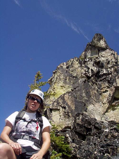
Readying ourselves at the trailhead, a mangy hulk looms into my peripheral view. I calmly turn my head to see a bear cub, probably in his teens, skirting our location. He's ignoring us... DEET has untold power... but we're more worried about Mama. We keep our heads on a swivel and with no sign of the parental unit we're off at 7:30 AM.
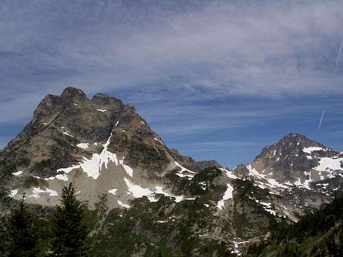
We traverse the long, gently winding cut up to Maple Pass, past the doubly magnificent Lake Anne and Heather Pass. The path is smooth, our feet find the dirt and rock without fail. In the cool morning we truck along easily making the pass in an hour and a half. And we are granted our first view of the objective.
The east face of old Corteo, from Maple Pass, seems an unsurmountable crumbling cliff-- but with a charming diagonal crack system. I remember the summitpost blog I investigated... traverse the boulder field under the east face to the southwest ridge... ascend the sw ridge until it seems you should veer back on to the face itself... aim for the notch between the two peaks and go for it. We talk it over from our vantage, munch on some gummy worms, chug a bit of agua and set out on our grassy, heather-filled romp over to Horsefly Pass.
It's about this time I chuckle to myself about the gummy worms. Reminds me of the jelly babies from Tom Baker-era Doctor Who. Yes, juicy companions ready to save us from despair in a cruel metabolic life.
Pushing through Horsefly Pass and heading for the snow-patched gravel beds below the east face, the aspect of Corteo becomes more and more manageable. We pause on some large boulders and recoup. We ponder how skiing down the main northern chute-crack of Corteo east would be ballsy, if not suicidal. There *is* one helluva valley runout afterwards...
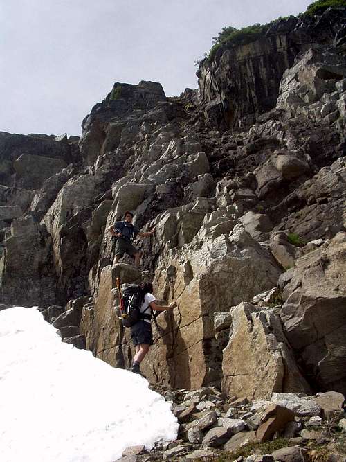
We decide to start the climbing phase with real class 5 stuff. Yup, probably only 5.2 to 5.5 for 20 foot pitches, but hey, look at us! Helmets on, trying to keep good distance. I get a little excited and find myself too close to Cara... up I look, down comes the baby-head rock, "oof"-- soft hit in the chest. Thanks for not bustin my mug. Ok, I'll back off and take it easy.
I top out after the third pitch and realize showtime's over. Now it's just a steady 3rd-4th class scramble up the southwest ridge. We take turns evaluating the route we're pushing, noticing the subtle signs that mark the trail. Heather on the ground and black lichen on the rock? Not the route. Dirty and gravelly with clean rock? Yup, we're on. We keep peeking over to the south and notice that the ridge is dropping off keenly. Soon it's clear we gotta head back onto the face.
I can sense that this mountain's been used for years. Sure, the rock is generally formed into 1-3 foot steps, but there's little handholds, footholds where there should be none. Some look like they've been chipped out of the rock long ago, worn down as they are. I wonder how many fortnight-grimy bandits have lugged some contraband, if not only themselves, over this mountain staircase.
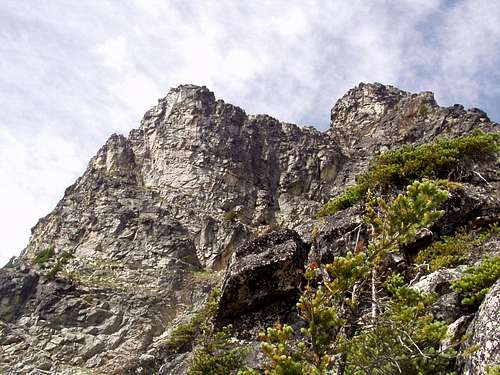
The upper east face is a playground. We've each spread out to eliminate rockfall hits and pump the steez. That ridge we just ran up put us above the cliffs that now separate us from the boulder field below. There were a couple pinch spots where only one or two routes would get you across, but nothing beyond 20 foot exposure.
I step forward and up, my fingers neatly wrapped around a horn, feet pressing me up economically. New rock ledges come into view continuously. Suddenly, a v-shape cutout of the world moves in parallax... the wind gusts... my focal length pops forward. We crest at the notch between the rounded south peak and the overgrown northern spine. That's a sheer dropoff. Let's stop.
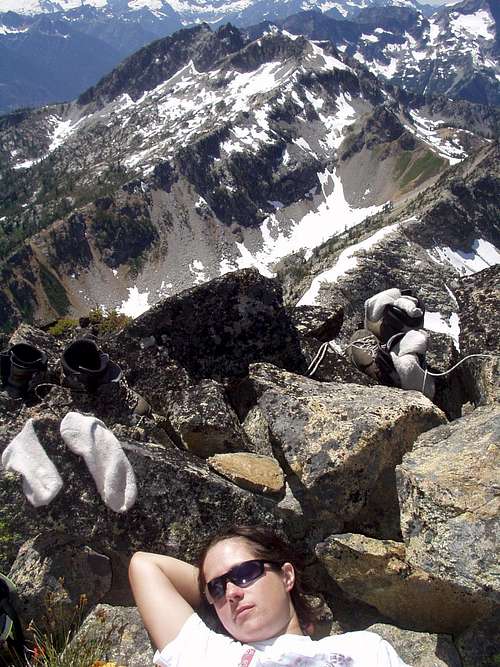
Danny, Cara and I decide the ascent is nearly over, we've got no more route beta, and we're hungry. Gummy worms slither down our throats accompanied by buffalo jerky [go get some at the deli next to Gustav's in Leavenworth!!!], replenishing us. The resident mountain goat, Daniel Herter, decides to scout the south peak route. We can all agree the north peak is out for the forseeable future. Maybe we'll blaze it when we come back with a full rack, trad experience, and a big wire brush.
We avoid the western drop by edging more towards the eastern playground we just ascended. It tends to keep the exposure to a minimum. We gain the peak with a smooth series of class 4 moves. More munching ensues and all is well.
INTERMISSION
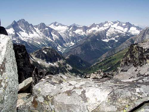
This place is different in the winter months. The southwest ridge route is plainly clear from here... it's a common route to take after summiting Black Peak to the northeast... across the nearly defunct Lewis Glacier. I suggest we do that during a coming winter. It's summer now, the air brisk and moving. There was supposed to be rain tonight. Nothing nasty looking out the west or the north, however the wind is picking up. Clouds are forming high above and to the east of the peaks in the area.
After scarfing sandwiches and snapping pics of triumphant poses, we descend. Climbing down is easy as there's at least two routes for everything. Back to the notch and onwards, to the nondescript stairway.
Our first memory test arose trying to get back on the southwest ridge. After a quick convo, we recall that the flat sunbathing rock was the crux.
The ridge passes quickly, we cross the boulder field and head for Horsefly Pass. On the way, a cold stream wending through the talus invites us to drink. I didn't remember seeing too many animals, so we drink. Water, the universal solvent, hadn't gathered much detritus in this batch [And as a forward, no gastrointestinal problems!].
We reverse the trail through the heather, up to Maple Pass and relax before the final walk out. The gummy worm and buffalo jerky supplies are exhausted. Glancing back at Corteo, mountaineering fundamentals dawn in revelation: get close enough to anything and you'll see it's exploitable flaws. And you'll love those flaws, because those very imperfections are what allow you to scale your objective.


Comments
Post a Comment