
-
 2482 Hits
-
 77.48% Score
-
 8 Votes
|
|
Route |
|---|---|
|
|
46.51146°N / 10.99935°E |
|
|
Download GPX » View Route on Map |
|
|
Hiking, Scrambling, Via Ferrata |
|
|
Summer, Fall |
|
|
Half a day |
|
|
Hike and Scramble |
|
|
Overview
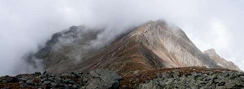 Clouded Ultener Hochwart / Vedetta Alta as seen from Schöngrubspitze Clouded Ultener Hochwart / Vedetta Alta as seen from Schöngrubspitze |
Of the many routes which head to the summit of Ultener Hochwart / Vedetta Alta the one which starts at Hofmahdjoch and heads for the summit along its east ridge is the shortest and most interesting one. It also is the route which covers least elevation gain but certainly is not the easiest one. It runs across the pastures of German speaking Deutschnonsberg, which for 400 years, however, have been in possession of the Italian villages of the lower Valle di Non (Castelfondo, Rumo). Thus this part of the route is of historical interest as well.
For about two thirds of the way the route described here is easy and follows mountain roads and well marked trails but the final east ridge ascent suddenly turns into exposed ferrata-like protected climbing. Before it does you can side-step to reach the easy summit of Schöngrubspitze (no Italian name), from where the remainder of the ascent route can be beautifully seen on a fine day.
Note: we climbed Ultener Hochwart / Vedetta Alta in fog - all the way from Hofmahdjoch. The pictures were taken when it "cleared up" sufficiently to see for 200m.
Getting There
See the main page for the itinerary to Hofmahdjoch. The saddle itself can't be reached by car, as a tunnel cuts through it but before and after (better) there are parking lots. Right after the tunnel (to its south) a dirt road turns off to Malga Cloz / Cloz Alm.Route Description
 Malghetta Cloz / Obere Clozalm
- Start altitude: 1700m
- Summit altitude: 2627m
- Prevailing exposure: South & North
- Type: Hike and Scramble
nbsp; - Protection: Short sections with cables and chains
 Looking towards Val di Non from Malghetta Cloz
From the southern parking lot at Hofmahdjoch retrace your steps for 200m, cross the road and enter on a dirt road, which leads to Malga Cloz / Clozalm. After several hundred metres you will reach the farm building, where several trails meet. Head out of the farmyard on its western side but immediately turn northward on trail no 7, which heads up the meadows above the alm. At first it follows a dried-up creek but then steeply crosses the meadows. After about an hour you'll reach the upper Clozalm near Glazner Joch Saddle, another trail intersection. The crossing trail Sentiero Bonacossa can be used to reach the ascent route on the south slope of Ultener Hochwart / Vedetta Alta. Rather stay on the northbound trail, which leads towards a saddle between Kleiner Kornigel / Monte Cornicolo and Schöngrubspitze.
In this place matters get a bit confusing. The maps claim that there is a direct ascent route to Schöngrubspitze via its east ridge. We found, however, that the regular trail turns towards the south slope of the mountain, alternating between level traverses and steep direct ascents. However, our visibility was about 20m in that place so that we might have missed a trail. Our - well marked - trail headed for the saddle between Schöngrubspitze and Ultener Hochwart / Vedetta Alta. Here trail no. 22 joins, which heads up from St. Weilburg in the bottom of Ultental / Val d'Ultimo. You can - if you like - sidestep to Schöngrubspitze from the saddle - some 100m of elevation gain along a broad ridge, which still is not without its pitfalls due to the brittleness of the rock.
 |  |  |
Back at the saddle the final ascent starts - 250m of elevation gain along and on the east ridge of Ultener Hochwart / Vedetta Alta. The first few metres are easy, as the ridge is still wide. The trail heads for the south side of the ridge and stays there for a couple of hundred metres. Going gets steep as it turns back to the ridge. Here the trail heads for a notch - to the right there is a big tower, separated by the ridge through just that notch. Beyond, a wide gully immediately drops down to the base of Ultener Hochwart / Vedetta Alta.
 "View" from the top
From the notch the trail traverses the north side of the ridge, which also rises very steeply. It is protected by several cables, but always only in sections of a few metres. The rock is polished, which makes these section dangerous in wet conditions like the ones we encountered. Finally it switches back to the south side of the ridge, where it levels into a traverse, which turns away from the ridge. Still there are exposed protected sections on blank rock, especially in a place where a big rock formation has to be passed. After this formation / buttress the trail regains the (now wide) ridge and easily leads to the broad summit area.