
-
 3558 Hits
-
 76.47% Score
-
 7 Votes
|
|
Route |
|---|---|
|
|
51.39750°N / 116.29417°W |
|
|
Mountaineering, Trad Climbing |
|
|
Summer |
|
|
Most of a day |
|
|
5.4 (YDS) |
|
|
II |
|
|
Overview/Approach
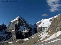
This is a 4700’+/- day. Unnamed Peak is just one of many objectives that can be reached via the Plain of Six Glaciers Trail in Banff National Park. This is the wide trail that actually starts at the Lake Louise Chateau (5680’) on the east end of Lake Louise. During the summer months, the start of this trail can be packed with tourists. However, if you get an alpine start, you will have it mostly to yourself, besides a porcupine, fox, etc, here and there. Proceed on the Plain of Six Glaciers Trail for over 5 kilometers as it bypasses the popular sport and trad climbing area of Louise Falls on its way to the Plain of Six Glaciers Tea House at 6888’. As you break out of the trees just west of the Tea House, your objective comes into full view to the northwest. Of course Mount Victoria and Mount Lefroy dominate most of the views. Popes Peak and Unnamed hem in the northwestern end of the deep valley that dead ends into the “deathtrap”.
Route Description

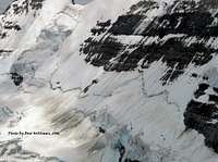


Follow the trail to the west end of the large scree/snow field that leads up to the glacier that hangs between Popes Peak and Unnamed. You will gain another 1000’ here as you follow a faint trail that crosses over a small drainage to the right as it ascends scree to the lower right hand corner of the significant headwall below the glacier. You are aiming to the right of any waterfalls visible from below. In July, we still had a solid snow slope that ascended the right side of the headwall waterfalls to a broad ledge that you use to traverse back left under the glacier. The guide book talks of hanging seracs although the real danger is the prevalent sliding rock on ice that creates a shooting gallery effect if you are traversing on a warm sunny day. Proceed quickly across this ledge crossing over a drainage or two aiming for the upper left corner where you will ascend the far western tip of the glacier as you continue to contour left so you can catch the east ridge.
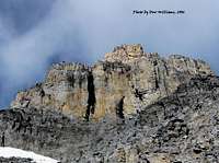
Once you are at the base of the East Ridge (cairned in 2006), scramble up loose rock (it is all loose, all the way to the summit) past a bivy spot gaining more of the defined ridge as you proceed. You will parallel a ridge to your left. Stay on the ridge to the right. You will see the first of two headwalls that were clearly visible down at the Tea House come into view quickly. You want to ascend an easy corner at the right side of this first headwall. I placed one piece of gear and slinged one rock. There is not much for placement, but I would have been comfortable soloing this grade as well. Once you reach the top of this first pitch, you move a little further up to actually find the rappel station, which was comprised of three pitons, one old, two new in 2006.
You can see the 2nd headwall from here. Do a mountaineers coil and work your way over some more tedious loose shale and rock to the center of this obstacle. There you will find a corner leading into a small chimney. Again, easy climbing, I maybe placed one or two pieces. Ascend to the top of the chimney and you should find quite a few slings wrapped around a significant piece of rock. Bring up the second.
Although I pitched the rope out on two more short walls for my partner that day, I did not place gear during the rest of the climb. Just stay on the ridge and don’t get sucked to the right ledges. Every time you think the rock is going to improve, the ridge reverts back to its old loose self. Finally you reach the summit ridge which is comprised of a small summit block (photo) and a very large snow slope that feeds the glacier below and leads over the Col to Popes Peak to the north. I scrambled up the summit block, but you can circumvent it to the right on the snow slope for an easier ascent. There was no summit register or cairn in 2006 despite the fact that Barry Blanchard offers this peak as a paid guiding trip.
You have three options for descent, the northeast ridge of Mount Victoria and thus down its northeast glacier, down the north glacier of Mount Collier into Lake O’Hara or descend the route which offers little reprieve to the knees. You obviously need to make your decision ahead of time in terms of transportation arrangements and gear requirements. We descended the ascent route via 3 rappels. The lower two I already discussed and a third that we slung off of a large horn to climbers right of a separate pinnacle type of feature further up. There should be two slings there now, some shoelace we found on it already and a nice wide blue sling that we left. It is skiers left as you descend the ridge.
Be careful once you reach that snow slope on the east side of the ledge below the glacier. A waterfall basically runs beneath it making some of that slope hollow. I could easily visualize someone glissading one moment on firm snow and falling through a weakness the next.