
-
 10652 Hits
-
 74.01% Score
-
 4 Votes
|
|
Route |
|---|---|
|
|
40.55170°N / 111.6561°W |
|
|
Hike with scrambling |
|
|
Half a day |
|
|
Class 3 |
|
|
Overview
The summit of American Fork Twin Peaks can be reached by a traverse of the east ridge, which begins near the top of the Snowbird Ski Resort tram. The traverse is an enjoyable scramble across an exposed knife-edge ridge.A loop hike can be created by combining this route with a descent via the Gad Valley route. Both routes begin from the lower parking area for Snowbird Ski Resort.
The east ridge begins near the top of the Snowbird tram, which caps the summit of Hidden Peak.
 |  |  |  |  |
Getting There
Take the 6200 South exit (exit #6) off I-215 and follow highway 190 south-east approximately 2 miles to the intersection with Big Cottonwood Canyon road. Continue straight through the stoplight and follow the road another 4 miles to the mouth of Little Cottonwood Canyon, where an electronic billboard on the right provides current road and/or weather conditions.Continue east up Little Cottonwood Canyon approximately 7 miles past the billboard to the Snowbird Lodge parking area on the right (south) side of the road.
Stats
One-Way Hiking Distance: 3.7 milesElevation Gain: 3,459 ft.
Average Gain per Mile: 935 ft.
Trailhead Elevation: 8,030 ft.
Summit Elevation: 11,489 ft.
Route Description
Beginning from the lower Snowbird parking area cross the concrete bridge and follow the service road a short distance up the hill, then follow it to the right (west) to proceed into Gad Valley.As is typical with ski resort hiking, there will be a number of service roads criss-crossing the slopes of the mountain. Simply follow the major road heading south as it winds its way up the mountain.
The road passes a lodge and restaurant, then continues climbing until it passes the top of the Gadzoom ski lift. Beyond the top of this lift the road climbs a short steep hill, then fades out becoming a trail.
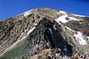
The summit of American Fork Twins dominates the view to the south, while the top of the tram on Hidden Peak lies to the southeast. The east ridge of AF Twins is the top of the headwall connecting the two peaks.
Follow the trail as it makes a series of switchbacks up the west slopes of Hidden Peak. The trail will eventually top out on the ridge a few hundred yards below and to the north of the tram, where it joins a service road coming up on the left from Peruvian Gulch.
Continue along the road as it winds around the south side of the tram to a saddle, marking the beginning of the ridge traverse. There is no maintained trail onto the ridge, but a use trail can be seen heading up the hill leading to the ridge.
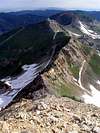
Follow the use trail as it proceeds southwest onto the ridge. The ridge is wide and level at first, but soon narrows until it becomes knife-edge. There is some moderate exposure across the knife-edge portion of the ridge, but the rock is generally solid and there are many hand holds.
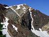
Eventually the ridge widens and soon after begins to climb the steep northeast face of AF Twins. Follow the path of least resistance up the steep scree and talus slopes, until finally arriving on the east summit of AF Twins. The higher west summit is reached by an easy 0.3 mile walk across the broad and rounded ridge connecting the two summits.