
|
|
Route |
|---|---|
|
|
36.52330°N / 118.238°W |
|
|
rock scramble |
|
|
One to two days |
|
|
Class 3+ |
|
|
Approach
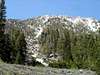
It is easiest to start at the Tuttle Creek trailhead. There are two different ways to drive there: a road with moderate amounts of huge rocks in it that is accessible through the Tuttle Creek Campground or a road with no major rocks but some weeds growing in the center accessible from Granite View Drive. The drive to the trailhead from Tuttle Creek Campground is the quickest and is easily doable for any automobile with moderate clearance. The road loops at the trailhead but make sure to park off to the side so others can get through.Route Description
This is probably the best scrambling route to the summit given that Army pass is just a hike/walk-up.First ascent: unknown to me
From the trailhead, follow the trail along the south side of Tuttle Creek. The trail follows the creek as it splits off to the south; at the point where it seems the trail crosses the creek, take the very lightly worn trail to your left up the hill. This "lightly worn trail" is not really a person trail since this area is not traveled much, it is more likely a game trail or something. Follow this trail staying high above the creek as it turns to the southwest towards Mt. Langley. If you miss this and stay low by the creek, you will undoubtedly spend unneeded hours bushwhacking up Tuttle Creek.
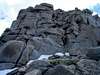
At about 8,200 feet, take the chute to the south to gain the ridge. There are game trails which zig-zag up the left of the chute; when these fade travel the chute until you approach the rock outcroppings to the west and travel over these until your reach the ridge (this includes about 1000-1250 feet of class 3 climbing to gain the ridge, some maybe-class-4 if you get off route). The ridge is fairly sharp so following carefully to the west towards Langley. At about 11,500 feet there is a substantially steeper section for about 500 feet that concludes at a gentle slope towards the summit block.
Continue following the east ridge towards the summit. At the base of the summit pinnacle, the route over the rocks is minimal class 3 with some traverse parts with awesome exposure. Don't fall here. Some stretches of snow (or loose scree depending upon season) must be crossed to keep on the rocks. Upon reaching the top, follow around the back to the summit.
 |  |  |  |  |
Essential Gear
In spring (or whenever it is snow covered), an ice axe is essential and crampons are strongly suggested. Depending up descent route, a rope may be helpful for rappelling. |  |