
|
|
Route |
|---|---|
|
|
37.23428°N / 112.87758°W |
|
|
Hiking |
|
|
Spring, Summer, Fall |
|
|
Most of a day |
|
|
Hike |
|
|
Overview
East Rim is a 10.5 mile long trail that connects the eastern parts of the park to the main Zion Canyon. The trail starts on Route 9 near the eastern entrance of the park (5700 ft). It then goes up to the top of a mesa (6750 ft) where it gives access to the Deertrap and Cable Mountain Trails. The East Rim trail, then drops into the Echo Canyon and loses elevation quickly to emerge at the Weeping Rock Trailhead in Zion Canyon (4350 ft).It is easier to hike the East Rim Trail from Route 9 to Weeping Rock (1050 ft of uphill followed by 2400 ft of downhill). You can pay the commercial shuttle buses in the town of Springdale to drop you off at the Route 9 Trailhead. Once you reach Weeping Rock, you can take the free park shuttle bus (April through October) back to Springdale.
The last (northernmost) 2.3 miles of the trail are common to the Observation Point and East Rim Trails.
 Map |
Getting There
From the eastern entrance to the park, drive less than 200 yards west on Route 9 to a road on the north side of Route 9 to reach the trailhead.Route Description
All distances are per my GPS.The trail leaves Route 9 and follows an abandoned Jeep Road near Clear Creek. You will have good views of the slickrock walls of the mesas around you.
 Near Route 9 trailhead |  Near Route 9 trailhead |  Near Route 9 trailhead |
The trail then makes a big switchback and goes up a slope to reach near the top of a mesa. You can look down to see the valley of Clear Creek where Route 9 runs.
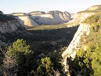 From the top of mesa |  From the top of mesa |
You will soon find yourself heading north on the eastern rim of Jolley Gulch, a narrow slickrock canyon. You can look north to see a majestic waterfall (when water is present). The trail eventually reaches Jolley Creek and crosses it just a few feet from the edge of the waterfall and goes to the west side of the Jolley Gulch.
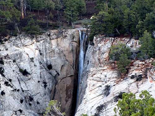 Jolley Gulch Waterfall |
 Edge of Waterfall |
 Jolley Gulch |
The trail then gets away from the rim of the gulch and slowly goes up in elevation on top of a plateau in a beautiful pine forest. It goes over a broad hump with a maximum elevation of 6750 ft and then slowly goes down in elevation.
 Pine Forest | 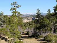 Pine Forest |
You will soon reach Stave Spring. Water exits a pipe here. A sign reminds you that this is Mountain Lion Country! A few hundred feet later, you will reach the junction of the Deertrap & Cable Mountain Trails.
 Mountain Lion Sign/Stave Spring |
As you go by the junction of the Ponderosa Ranch Trail, you see a plateau covered by sage.
 Sage on Plateau |
After the junction, you will note that a deep canyon comes to form on the left side of the trail very quickly. This is a branch of Echo Canyon.
 On Echo Canyon Rim | 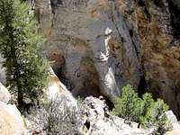 On Echo Canyon Rim |
The trail continues on the rim of the canyon for a short time and then begins to make a long series of twists and turns going down a steep slope.
 Trail |  Trail |
You will get magnificent views of slickrock mountains and canyons all around you. In some places, you will have to watch for cairns on slickrock to find the trail.
 | ||
 | ||
 |  |  |
 | ||
 |  |  |
 | ||
 | ||
After the junction with Observation Point Trail, the trail gets into the bottom of Echo canyon going through a tight/slot canyon.
 Descending into Echo Canyon |  Echo Canyon |
 Echo Canyon | |
You will then reach a seemingly endless number of switchbacks above Weeping Rock. At the bottom of the switchbacks, you will reach the Zion Canyon Park Road.
 Descending to Weeping Rock |
Red Tape
You must pay park entrance fee.No permits needed for day hikes. See link below for all rules and regulations:
http://www.nps.gov/zion/index.htm
weather
See the forecast for Springdale, UTExternal Links
Website:East Rim
Books:
A Falcon Guide, "Hiking Zion & Bryce Canyon National Parks", Eric Molvar & Tamara Martin.
Maps:
National Geographic, "Zion National Park, Utah, USA" #214