
|
|
Route |
|---|---|
|
|
39.85220°N / 105.6894°W |
|
|
Hike |
|
|
Most of a day |
|
|
Walk up |
|
|
Approach

This great aerial picture gives a spectacular general overview of the eastern side of James Pk. The lines correlate with this TOPO! map.
Great thanks to dgreaser for this picture.
Start from the Saint Mary's lake trailhead. Take exit 238 on I-70, and follow Fall River Road (County Road 275) up to the town of Alice and up to the trail that leads up to the lake. Parking is the hardest part of the ascent and can be almost impossible on busy summer weekends when the place is packed with tourists. Much of the parking spaces are either along the roadway of in pullouts. There is a full parking area at the base of the old ski hill, but I think it's closed. There is large pullout/parking area that holds approximately a dozen cars right below a dirt wall on the left (west) side of the road. In many cases your best bet might even be to send out a scout on foot to spot where the best spots are; they might be very far away. Much of the Alice area is surrounded by private property or dirveways, please be respectful of the property owner's rights.
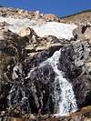
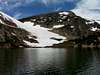
Hike up this trail for a a quarter mile up to the lake. Hike around the east side of the lake and to the base of the glacier. The total distance to the base of the glaicer is less than a half mile. St. Mary's lake and Glacier is a beatiful place, and a great place to pracitce various forms of snow climbing. It is also a great place to carve a few turns in summer. This is also the starting point for various longer backpacks along the Continental Divide.
 |  |  |  |  |
Route Description
Climb up the glacier until it ends after a about a half mile. Above the glacier slowly climg up the gentle grassy slopes that slowly wind their way up James' East Side. At about 12,000 ft. the slopes steepen a bit before flattening out again at 12,800 ft. below James' final summit pyramid. Climb the remaining three hundred feet up the summit pyramid to the summit itself. This route is rated a grade D2 ski descent. |  |  |
Essential Gear
The "glacier" is more of a snowfield than an actual glacier, and therefore does not require the kind of technical skill that a regular glacier requires. It is also not very steep (in most parts) and therefore does not require gear such as ice axes and crampons. Trekking poles may be useful just to keep your balance. In summer the glacier is crawling with scantily clad tourists who come from as far away as Texas to stand on snow in July.Gear needed should include trekking poles for balance on the glacier as well as sun protection gear. James Peak is on the Continental Divide and therefore prone to severe weather. Prepare for the weather adequately. I've seen snowstorms in these parts in August.
Kingston Mtn.
Kingston Mtn. is a small subpeak on the James Peaks east ridge. Kingston Mtn. is a generally unimpressive peak; gently sloping up from the grassy slopes above SMG. It's summit is however worth a visit since it provides absolutely spectacular views. To the west you can see the huge bulk of James Peak, and its rugged east face. To the south you can look out to the Clear Creek drainage and the high massifs of the Front Range. To the north you can look out to the IPW and the high peaks of RMNP. Spectacular views such as these are easily accessed only a short distance from the main trail leading up James Peak. To access its summit climb one mile and a thousand feet from the top of the glacier over gentle slopes.Fox Mtn.
Fox Mtn. is a rocky summit directly to the east of St. Mary's Lake at the foot of the glacier, and offers a spectacular rocky viewpoint over the glacier and much of the front range. Fox Mtn. is rarely climbed by the tourists because of its rugged appearance, and therefore offers solitude and a great way to enjoy the beauty of the place without being elbow to elbow with three hundred of your best friends. I love to come to this place in summer when the weather is nice and spend hours on the summit, relaxing, admiring the view, and laughing at the scantily clad tourists slipping around on the snow.Fox is a short climb from the lake and can be climbed as an easy class three with proper routefinding. The best way is to climb it directly up its west side from the lake. Climb through the trees to directly below the rocky summit block. For the last fifty feet climb directly up a loose gully to the rocky summit.
 |  |
Point 11,716
This small unnamed point is very much like Kingston Mtn. except that its a shorter hike and doesn't offer such spectacular views to the north. This point is a nice place to get an overview of the rest of the upper part of the area and gaze up at Kingston and the Continental Divide. From the top of the glacier hike less than a hlaf mile to the southwest to attain its grassy summit. A lot of people pas by here on their way to bigger adventures at higher elevations.Point 11,716 is also important because it is the summit of the steep slopes on the western of St. Mary's Lake. A steep (probably close to 50 degrees) but prominent couloir cuts through the center of this face. This couloir makes for a wonderful climb. However a fall in this couloir would result in you ending up right in St. Mary's Lake. Because this couloir ends up right in the lake access to its base can be difficult, requiring you to skirt some steep slopes while avoiding getting your feet wet.
 |  |
CharlesD - May 10, 2005 10:12 pm - Hasn't voted
Route CommentParking is the most difficult part of the ascent. There is a large parking area at the base of the old ski hill which has been permanently closed with some large boulders. Shortly after this is a smaller lot which holds about a dozen cars and fills up early on weekends.