
|
|
Route |
|---|---|
|
|
37.68000°N / 107.392°W |
|
|
Hiking, Scrambling |
|
|
Spring, Summer, Fall, Winter |
|
|
One to two days |
|
|
Class2+ |
|
|
Intro
This route can be done in a day, but it would be a long one due its nearly 20 mile round trip mileage. Many would suggest breaking this trip up into a two day backpacking trip. I recommend the backpacking option, as it allows you more time in which to experience this special place. There are some good camping sites on Weminuche Pass, near where the route leaves the Weminuche Trail and starts up the Opal Lake Trail.Mileage:
Round-trip from trailhead to summit: 18.5 miles
Round-trip including hike to the Window: 21 miles
Approach
Start at the trailhead for the Weminuche and Big Squaw Trails at the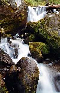
Weminuche Creek
You will encounter the first of three side creeks at around mile 1.6 (measuring from the trailhead). Creek #2 at approximately mile 3.85. The third creek crossing at mile 4.9 is actually Weminuche Creek, which you have been following up to this point. [There are a few areas along the trail where it is muddy, or has a little water coming across it. These spots are not the side creeks that you are counting. If you are in doubt about whether or not a little stream was one of the creeks, it wasn't......you'll know the creeks when you cross them.] The not-at-all very lofty Weminuche Pass is about 0.2 miles past this 3rd creek crossing. In fact, unless the map told you that this area was a mountain pass, you'd probably never know. If you have elected to spend the night and then push to RGP in the morning, this is a great area in which to camp. To the east of the trail there are some good camping spots in the trees. The creek also provides water. Be sure to replenish your water supply here before pushing on to the mountain and the Window, as this is the last reliable water supply you will encounter along the way.
Route Description
Just after the 3rd creek crossing (Weminuche Pass area),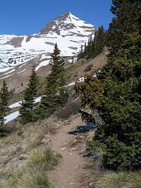
Opal Lake Trail
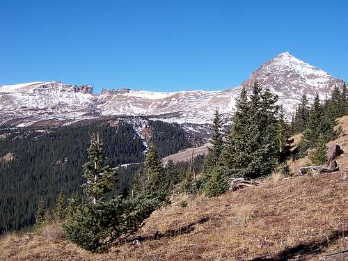
Once on the Opal Lake Trail, follow it as it climbs up the ridge to the west. The trail will eventually leave the ridge and begin to traverse the south facing slope above the Rincon La Vaca valley. This trail is not accurately shown on most maps. It is generally higher than it is shown in Gerry and Jennifer Roach's book, Colorado's Thirteeners, and lower than depicted on the Trails Illustrated map. The good news is that there is an actual trail to follow. The bad news is that it has in the past had large deadfall across it in places, and the trail had worn it's way around these obstacles. (I was told by a National Forest Service Employee in 2004 that the Opal Lake Trail was no longer maintained. [2017 update: There now seems to be even more deadfall across parts of the trail. It is a shame that this trail is not maintained, as it really is quite an interesting trail, and in my opinion, the best approach trail to use when climbing RGP]) At around 12,000 feet, the slope will ease and you will find a flat area. You will also find a mess of willows to contend with. The trail does still push though these tall willows, however if you are not careful, you may trip and find yourself lying amongst them! At 12,200 ft. leave the Opal Lake trail for an unmarked spur trail heading off towards the NW, and the 12,645 ft saddle between RGP and UN 12,278. At this point you are nearly 3.5 miles away from Weminuche Pass. As the slope you are ascending begins to relent, and before actually reaching the saddle, turn to the left (WSW) and toward the challenge that you have come all this way to meet.
From here there are more than one option. (See this Route Photo) You can chose to climb directly up a steep, scree-filled gully with an evident use trail onto a shoulder buttressing the east ridge of the summit pyramid. You can chose to take a route off to the right and scramble up steeper rock, or you can bear to the left and take a longer but less steep way up to the top of this obstacle. This shoulder is topped by point 13,185 on the map. From here the final stretch of the climb looms before you. Begin up the east ridge of the summit pyramid. Stay to the left to avoid the more difficult and messier right side of the ridge. The talus you encounter here is steep and unstable. You will encounter large chunks of rock that will move underneath you...be careful! Amongst the long cooled remnants of Rio Grande Pyramid's more violent past, you may spot signs in the rock of a time when the area was much warmer and fluid. After you make your way to the top of this dynamic pile of igneous rock, the summit of this special peak is yours.
The Window
To visit Rio Grande Pyramid's Window, follow the route you ascended back down to the Opal Lake Trail. Follow the trail for about 0.2 mile before leaving it to cross the open terrain. Head south, then southwest around a rounded buttress. Continue southwest toward the Window over flat ground. Nearing the Window, hike upwards until you are within the great, timeless notch. Enjoy the view through this, the grandest of windows.On the way back you might choose to head down toward Opal Lake, which is ESE of the Window. From the lake you can pick up the Opal Lake Trail again and follow it to the NE. Bear left at a trail junction about 0.9 miles from the lake. Continue along the Opal Lake Trail back to Weminuche Pass.
There are ways by which you can descend RGP's lower flanks on the south side in order to make for a more direct route to the Window. However, if you chose this option, please be very careful. The south side of RGP is a steep mess of loose rock and eroded volcanic tuff. Broken cliffs abound on the face. Make sure you check out any descent route on the south face before you commit yourself to it. Or better yet, retrace the ascent route back down to the main trail.
Rio Grande Pyramid and The Window
Essential Gear
Be sure to bring the standard outdoor essentials. Due to the shifting talus of the upper cone of the mountain, boots, as opposed to lighter footwear, would likely be beneficial for added stability and support. Trekking poles may also come in handy for stability. If the mountain has snow on it, an ice axe would be a good idea. Crampons would be needed if the snow was hard enough that steps could not be kicked.Maps

Full Route

Trailhead to Pass

Pass to Summit