Description of the route
It was a 11-day trek in the wildest mountains I have ever been. No paths, no other tourists, no shepherds, no infrastructure, no trace of humans - only the ocean of rocks. The rocks in these mountains easily move and the ground is not stable (according to the geological structure - Baikal tectonical fault). It was a hard trek with some really difficult passes - it was necessery to be very careful on ascents and descents as it was very easy to move huge stones and make them falling on the people who were just going below. Although almost all passes were 1a class (trekking)in Russian scale, some of them should be considered as minimum 1b.
![..]() Girls' Team at the Baykonur Pass
Girls' Team at the Baykonur Pass![..]() Men's Team at the Baykonur Pass
Men's Team at the Baykonur Pass
A few hours walk from the road in Tunkinska Valley towards the most southern peaks of Tunkinskie Golce - through a flat, swampy meadows, with no spectacular views due to the fog. At this moment we were really afraid that the weather will be ugly all the time - rain is a common thing in these mountains.
Day 2.Shuntyn-Garhon Valley - high parts of the Chertolen-Garhon valley
In the morning, 1 hour after waking up, the sun appeared on the sky and it stayed there for almost all days of our trek.Quite a demanding hike up through forest, at around 6pm we left the forest and set camp at the meadow just below rocky parts of the moutains with the view to Pervomayski Pass on the north and to Chamar-Daban mountains on the south.
Day 3.Chertolen-Garhon valley - Pervomaysky Pass (2700) - Hubutsky Pass (2493m) - Hubyty valley
Quite easy hike up to Pervomayski Pass. Going down was much more stressing. Bagieta moved 2 huge stones and they started falling quickly towards other people below. I touched a stone (of a Tv set size) and fell down with this rock one meter down and I seriously tore my trousers. It was the 1st time we put on helmets.Then we hiked quickly another pass - Hubutsky and set camp just below Granatovyj Pass.
![..]() Towards Pervomayski Pass
Towards Pervomayski Pass![..]() Rocky Peaks of Tunkinskie Golcy
Rocky Peaks of Tunkinskie Golcy
Very intensive and also stressing day.
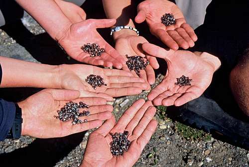
Quickly arrived to Granatovyj Pass - the name of the pass comes from the small red minerals - granets - in 15minutes each of us gathered a pile of them.
![..]() Looking for granates at Granatovyj Pass
Looking for granates at Granatovyj Pass![granates]() Granates
Granates![..]() At the Granatovyj Pass
At the Granatovyj Pass
Then in 15 minutes we went to Nadezhda Pass with quite steep descent (falling stones again).
![..]() Steep descent from Nadezhda Pass
Steep descent from Nadezhda Pass
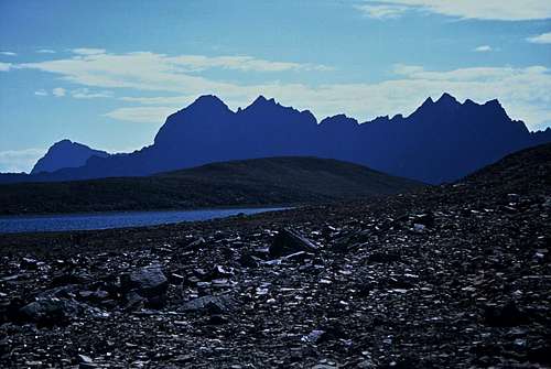
Finally we reached very rocky, grey valley with slagheaps of stones and with the sound of coming thunderstorm reached the pass. The descent on the first sight seemed to be almost vertical. We were really frightened and thought it can be impossible to go down. Finally, we were going down with a big distance between one person to another, starting at long intervals, to avoid falling stones (some of us also used a rope at first meters of a descent). At 23.00 we arrived to the edge of the lake at set a camp.
![..]() In Zungolsky Valley
In Zungolsky Valley![..]() View from Zungolsky Pass
View from Zungolsky Pass![..]() View from Zungolsky Pass
View from Zungolsky Pass
After stressing descent last day we decided to make a light day (but finally it ended as normally, very late).
In the morning we had nice breakfast combined with swimming in a freezing waters of wonderfully blue lake.
Then we set out towards Schumatske Istochniki. We traversed a long valley going up and down (tiring), crossed Levyj Schumak river without problems and set a camp by the main path leading to Istochniki(the only well visible path on the trek).
![..]() No-name lake behind Zungolsky Pass
No-name lake behind Zungolsky Pass![..]() No-name lake after Zungolsky Pass
No-name lake after Zungolsky Pass
In few hours we arrived to local Aqua Thermal. This is an area with pools - natural or made by people - with mineral waters of various types, with curative and medicinal propoerties.Many Russian peopole travel here through Schumak pass. They stay here in woodden cottages located in the forest and after 1-3 weeks they go back through the same pass(often on horses). Luckily this nice area nd its natural resources has not been destroyed or devastated and human's activity here is not significant still - the only "infrastructure" are the cottages, 1 shop, bridges over the rivers and some pools but everything is made from wood - no concrete, no dominants, no other infrastructure. In the shop you can buy only very simple products - sweets, chocolates.Im not even sure if they have beer (or maybe it was so expensive that I did not pay any attention to it).
![..]() Levyj Schumak Valley
Levyj Schumak Valley![..]() In Schumatskye Istochniki
In Schumatskye Istochniki![..]() Dacan in Schumatskye Istochniki
Dacan in Schumatskye Istochniki
The day in a fog, first half along Pravyj Shumak river valley , then we turned to the east towards Dolgozhdannyj Pass. We slept in high parts of the valley.
Day 7.Pravyj Schumak Valley - "Dolgozhdannyj" Pass - Levaya Bilyuta Valley
The most stressing day ever in the mountains. Dolgozhdannyj Pass was expressed in one Russian description as "Absolutno ne vyrazhena kak pereval" what meant it did not look like a pass at all.
We arrived to the bottom of rocky, vertical wall and we only knew that the pass is somewhere high up but it was really not clear where exactly it can be.
![Dolgozhdannyj Pass - somewhere there on the ridge]() Dolgozhdannyj Pass - somewhere there on the ridge
Dolgozhdannyj Pass - somewhere there on the ridgeKwito and Kuba went to make recoinassance and we stayed and observed them with field glasses. We saw they make really risky things - some parts required climbing. After 3 hours they called us to come to them.
First part of ascent was steep with slabs of stones. Not nice.
![..]() Hiking up "Dolgozhdannyj Pass)
Hiking up "Dolgozhdannyj Pass)![..]() A rest during the climb on "Dolgozhdannyj Pass"
A rest during the climb on "Dolgozhdannyj Pass"![..]() Climb on "Dolgozhdannyj Pass"
Climb on "Dolgozhdannyj Pass"![..]() Climb on "Dolgozhdannyj Pass"
Climb on "Dolgozhdannyj Pass"Then we had to climb in a steep couloir with falling stones. We went with keeping big distances between each other. The views from the pass were magnificent! When we were on the ridge it turned out that we climbed ton Dolgozhdannyj Pass but another one (probably more difficult). D.Pass was more on the left at the ridge.
We set up camp just after reaching the valley at the bottom on the other side of the ridge.
Day 8.Levaya Bilyuta Valley - Baykonur Pass (2820m) - Pravaya Bilyuta Valley
Another long but probably the most beautiful day. After leaving a camp,we reached an interesting canyon, then beautiful lake. But the best was later.
Ascent to Baykonur Pass was long but technically easy - finally no stress. When you reach Baykonur Pass at the second half of a day, the view is like from a dream. You see a big lake (as the saddle is very wide and long) and on the background You see black contours of the high peaks.
![Baykonur Pass]() The first view after reaching Baykonur Pass
The first view after reaching Baykonur Pass
Water in the lake is usually rather warm as it is not very deep.If you are there you MUST hike up 10 minutes to the top of the ridge towering on the northern side of the lake. The view was probably the best I have ever seen in mountains!!
![..]() At the Baykonur Pass
At the Baykonur Pass![..]() At the Baykonur Pass
At the Baykonur Pass
Way down a little bit stressing because of the canyon where we had to use ropes to transport backpacks (with them on the backs it was risk of falling down). The camp by the lake on the meadow with cotton flowers.
Day.9 Pravaya Bilyuta Valley - no-name valley towards Bepkan Pass
Very tiring day along Bilyuta valley. In a big hot, without path.
![..]() Pravaya Bilyuta Valley
Pravaya Bilyuta Valley
Then we turned east toward Bepkan Pass. This second valley on its left slope (were we walked) was so steep that it was imposible to hike up. We went down to the bottom of the valley and changed route to the right slope.
![..]() Cotton in Pravaya Bilyuta Valley
Cotton in Pravaya Bilyuta Valley![..]() Pravaya Bilyuta Valley
Pravaya Bilyuta Valley![..]() Pravaya Bilyuta Valley
Pravaya Bilyuta Valley
The route to Bepkan Pass not difficult but a little bit risky because of ..surprise, surprise: falling stones again!. When we reached the pass it started to rain and it was raining almost till the end of the day.
The fog/clouds also came and it was really hard to walk not to losse something what seemed to be a path! The valley we were going down has 4 or 5 lakes so it must be scenic but we did not see anything. We set a camp in the forest. During 3-hour-walk in forest we saw only 1 place where it was possible to put a tent but we did not use it. We were going further and further and there was no other flat place to put tents, finally we slept in strange position on the clumps of moss.
Day 11. Barun Handagay Valley - Zun Handagay Valley - Arshan
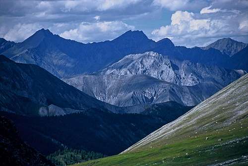
![View to Kitoyskie Golce (on the north from Tunkinskie G.)]() Typical view
Typical view
Nice walk down with the path, many moskitos in the forest. Finally we arrived to Arshan.
How to get
We took a minibus (with a driver) from Sludianka to Nilovka/Hoytogol. We drove about 3-4h.
Comments
No comments posted yet.