
-
 4113 Hits
-
 83.1% Score
-
 16 Votes
|
|
Route |
|---|---|
|
|
47.37653°N / 11.55899°E |
|
|
Mountaineering |
|
|
Summer, Fall |
|
|
Most of a day |
|
|
UIAA grade II in parts |
|
|
II |
|
|
Overview
 Hochglückkar and east ridge to summit
In my opinion the east ridge route to Eiskarlspitze is the best route because it seems to be the only route to this summit in quite good and stable rock. What I heard and red about the other mountaineer routes, e.g. Eiskarln route, is bad and loose rock in steep rockfaces and difficult route finding.
Hochglückkar is only crowded in springtimes when many, many people do the famous ski hike up to Westliche Hochglückscharte. In summer and autumn, however, you will be (nearly) completely alone even during sunny weekends.
You can combine the mountaineer routes of Eiskarlspitze to some interesting and long traverses but, despite of being a traverse monster myself, in this case I recommend the descent like the ascent on the east ridge route.
Getting There
 Hochglückkar - view to Sonnjoch
The east ridge route to Eiskarlspitze has two main trailheads, both on the northern / northeastern side of the mountain:
Eng Almen: see the Eiskarlspitze main page how to get there.
Lamsenjochhütte:
This mountain hut can be reached from:
Route Description
Hochglückkar
Eng ascent
Follow the road, starting at the parking area in southwestern direction to Engalmen. Pass Engalmen until you reach a road junction. Follow the left hand road some 500 meters in the direction to Binsalm / Lamsenjochütte until you cross a creek. Take the trail to your right immediately after the creek, it is called the “Drijaggen panorama trail” (signpost).
 Hochglückscharten Hochglückscharten |  First scramble after Hochglückscharte First scramble after Hochglückscharte |
The trail ascends some meadows and turns left, ascending the left hand slope. Leave the trail here, aim right and cross the creek again. Start ascending the meadows on the west side and parallel to that creek, after a while a new trail starts and zigzags up the slope to reach “Kirchl”, a huge solitary rock under the towering perpendicular rockfaces below Eiskarln. There is a huge waterfall coming down from Eiskarln, an impressive sight.
The creek, coming down from Eiskarln and a spring a little above the creek is the only water supply of the route (!)
The trail traverses Kirchl meadows to the left (east) and starts ascending meadow and dwarf pine overgrown ledges, always traversing in eastern direction.
After a while the traverse ends and the trail starts climbing steeply the slopes below Hochglückkar. At some huge cairns the route reaches lower Hochglückkar with its impressive width, many karst features and good views of the surrounding rockfaces.
Another steep slope leads up to the middle part of Hochglückkar. The trail dissappears beneath the rock outcrops but the route is marked with cairns. The route stays in the middle of the huge cirque but you can find your own route in the eastern part of the cirque, too. The western part, however, is a scree filled sink and is not recommended as ascent (or descent) route. This part is commonly used as downhill route for the famous spring ski tour to Westliche Hochglückscharte.
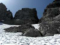
The upper part of Hochglückkar sees more rock and scree and then an everlasting snowfield, stretching steeply up to the twin notches of Östliche and Westliche Hochglückscharte.
 East ridge - south side East ridge - south side |  Climb after first culmination point Climb after first culmination point |  the "cockscomb" - crux the "cockscomb" - crux |
Lamsenjochhütte ascent
Follow the trail from the hut to Eng Almen until you reach Westliches Lamsenjoch. From there a long traverse starts in western direction on scree fields below Lamsenjochspitze, Mitter- and Schafkarspitze until you reach the Kaisergrat ridge, coming down in northwestern direction from Schafkarspitze.
A meadow ledge leads up to a notch between the last spires of that ridge. On the other side of the notch an easy descent leads down to the lower parts of Hochglückkar. Ascend Hochglückkar - looking for your own route - to the upper parts of the cirque and the snowfield where both routes meet.
Summit ascent
Climb up the steadily steepening snowfield. As it is a northern exposition this snowfield can be hard and even icy. Depending on the conditions an ice axe and crampons may be useful.
Aim to the chute which comes down from the right (western) notch of the twin notches. Climb the chute on snow and / or rock (UIAA grade I); there are still some old steel ropes which are fixed badly; do not use them! Pay attention to loose rocks in that chute.
Don´t use the left chute to the left notch!
Arriving at the notch turn right and traverse on the south side some easy but exposed rocks up to a subridge (cairn). Follow that subridge in easy rock scramble to a first culmination point of the east ridge.
 Climbing the third culmination point Climbing the third culmination point |  Below first northern traverse Below first northern traverse |  The northern traverses as seen from summit ridge The northern traverses as seen from summit ridge |
Descend into the notch west of the culmination point. Now the ridge gets sharp and exposed, especially on the north side. Tackle this part of the ascent by staying directly on the ridges edge; the rock (UIAA grade II) is firm and good to climb but exposed. The wildest part is called “Hahnenkamm” (cockscomb) - you can traverse that part on its south side with good grips on the edge of the cockscomb or you can “ride” over it.
Addition 15-08-2013: The beginning of the steep, exposed ridge and some other parts of the ascent route are now - very sparsely - marked with little red dots and arrows. Useful for those who do the route for the first time - but kind of loosing the innocence of an unmarked route, too.
The ridge gets now easier and leads up to a second culmination point (scree filled rock slabs). Now you arrive at a nearly level part of the ridge - stay on the ridges edge with deep, deep views down the northern rockfaces or traverse that part slightly below the ridges edge on the south side (rock slabs with loose scree).
After a small and exposed notch the ridge gets steep again (now red dots as marks) and leads up to a third culmination point. Scramble up steep limestone slabs (UIAA grade I to II - exposed especially during descent) and stay near the ridges edge; there is less scree than on the south side.
A short level part brings you to a very steep, huge block which looks wicked (my guess: UIAA grade IV - V when climbed directly). Don´t go into the south side ! Use a steep rock ledge leading into the north side (2013: now a red arrow to indicate the right direction), climb up that ledge in good and firm rock until you arrive at a broad scree and rock chute which leads back to the ridge (some cairns and another red arrow for the downclimb).
Normally there are huge corniches in spring and early summer around the above mentioned third culmination point which can make the short north side traverse very difficult to impossible. Sometimes these then melting corniches produce a little water supply in july.
 Summit panorama north, 180 degrees
Follow the ridge up to the summit block. There again traverse into the north side on a scree ledge (2013: again a red arrow and some red dots), climb up some exposed rocks to a second, steep rock chute with much loose scree. Climb up that chute, arriving at the nearly level and exposed summit ridge (another red arrow for the downclimb).
Follow the exposed summit ridge to the little cross near the highest point of Eiskarlspitze.
Gear and Mountain Condition
 Ascent from Kirchl to Hochglückkar
If you easily master UIAA grade II you need no rope for the east ridge.
Good belaying is rather difficult because there are not many good stands and no bolts. Good shoes are a must for the snow fields, ice axe and crampons can be very useful.
The weather should be stable for climbing the ridge. Eng valley and the surrounding mountains are a trap for thunderstorms, so be careful.