So Which Mountain Are We Climbing Anyway?
Seems my buddy Steve and I get around to climbing a peak or two each year since we met taking a week-long expedition mountaineering course through Timberline Mountain Guides on the north side of Hood in 2001. We decided to try Sahale Peak this year and Steve flew back early from his family vacation out east to do this one. Before I made the drive up to his place north of Seattle from Portland, he had called and said we could not get a permit for Sahale. So, I had some back-up plans in mind but when I got to Steve's house about 9pm on Friday, he had been looking through Summitpost for something and wanted to do Eldorado. Seemed like a great idea to me, I have seen lots of photos of that thin final summit ridge and would love to climb it. (Plus, now we would not have to take in any rock pro.) He already had confirmed we were good with the permits for that area and the forecast appeared that bad weather would hold off until Sunday night.
We set out early Saturday morning and got the permit in Marblemount at the Ranger Station. Got to the trailhead and started at 9 am. Right off the bat, you cross a narrow, smooth log (or series of them) that was not so fun with the packs on. Then the trail launches (and in this case, that is the correct term) up through the forest. Over and up roots and rocks, lots of blowdown you are ducking under or straddling over. The going was slow with full packs but we managed to get up to the talus field in a little over an hour.
We took a break there and then headed up the rockfield. More like a boulderfield, lots of high steps and scrambling but doable. There are some cairns but it is still easy to lose the "trail" and we weaved in and out of what probably is the route. For reference though, if in doubt, head to the right (east) side of the rockfield as it seems to mostly be over there.
![]()
The rockfield takes freakin' forever and is just really slow to get through. Came across a hornets' nest under one so beware! Towards the top of the talus/boulders, you exit right into a brushy area by a series of waterfalls. We took our second break here for lunch and enjoyed the lovely large horseflies that I think we could have saddled and flown to the top if we had been thinking. (As I type this almost a week later, I still have a large welt on my left forearm that itches from the ba$tards!)
![]()
Anyway, once we started up again, the views opened up from the in and out clouds we had been going through and we could see some peaks above us and lots of green meadows. The path stopped going straight up and leveled off more. There were now lots of wildflowers and little streams and a nice green alpine meadow. Marmots screeched at our arrival and pikas bleated goodbye from the talus below.
![]()
From the meadow you can look left and see the ridge you must attain and go over for the normal route. The alpine meadows are my favorite pladces on mountains and it went by all too soon. The green gave way to grey granite and we crossed a small stream. The route is flagged left away from the worn-in path and the rangers had told us that they are trying to get people to hike through a different area now to give the previous path time to recover from years of use.
![]()
Once we made it to the ridge we could look over and see the glacier-scarred granite fields with snow dotting it. Above that was the toe of the glacier with blue crevasses seen criss-crossing all over. At this point, we thought we had to go up the ridge to get the descent gully out onto the moraine. We both went around a small bump of grass on either side and then didn't see each other for about 20 minutes. I continued up thinking the gully was way up the ridge and Steve had actually found the right gully close to where we came up from the meadow. Once I realized Steve was nowhere around, I headed back down, cursing at the extra 200 feet of elevation I had just done. The correct gully is steep with steps in grass made for people about 8 feet tall. (I am not that tall.)
![]()
At the bottom of the gully, you hike up left of the moraine through boulders and snow until you come out above the morraine on granite and snow slabs. We could see the route up the left side of the ridge we had just descended and there was a small dirt and flowery ledge between levels of the rock we were on and the snow below the glacier.
![]()
We went up that and then slowly over wet slabs from melting snow. We could now see clouds rolling over the ridge above us and the glacier. More clouds were coming from the west. We made the decision to camp here at 6600 feet instead of going up to the 7500 level where normal camps are made. Our thinking was that it was only about 2000 feet to the summit and if weather kept coming in like it looked, we didn't want to be up there descending a crevassed glacier in whiteout.
![]()
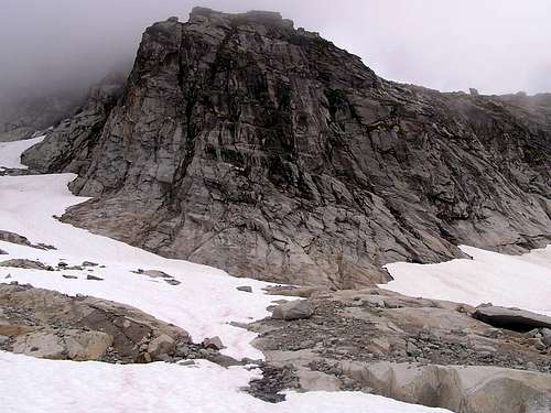
I had brought my new Black Diamond Lighthouse tent and set it up on some snow we flattened out while Steve got water and dinner going (even though it was only about 3:30 or 4 pm, man we were hungry!). Three groups of climbers descended out of the clouds above who had summited, one by the northeast ridge. They said the route was in decent shape but they had gone up early today instead of waiting until tomrrow as planned due to the weather lokoing sketchy. They didn't want to lose their window to summit and that was mighty smart thinking of them in retrospect.
Dehydrated dinner was eaten and we shot some photos and turned in early. Even when we got up to pee at 11 pm, the weather looked ok. Clouds were in and out and nothing too bad. There was a large rock buttress we camped near that we kept looking at from the tent (see photo). The first in my series of misadventures happened when I realized my thermarest pad was deflating. The same thing happened to me with the same type of pad on Rainier and I spent the night sleeping on the rope there to provide some sort of buffer. And just the week before the same thing happened on another pad at home when I slept in the basement due to excessive heat in the Portland area. I came to the conclusion my cats must be kneeding the pads where they sit under my bed while in storage. Damn felines! What I did was put all my shells, gloves, parkas, clothes, under me in my sleeping bag and it worked well enough for me to fall asleep this time.
![]()
View from the tent at dinner
![]() View from the tent in the morning
View from the tent in the morning
At 4:05 am, I was brought awake by a sound of pellets on the tent. When I looked out, visibility had all but disappeared and the tent was being covered in snow. At 5 am, when the alarm went off, it was no better and we debated what to do. Grey gloom above us with maybe a hundred yards of visibility coming in and out, snow blowing in, it just didn't look good. We decided to bail for the first time in 6 climbs together. It was the right decision as things did not get any better the rest of the day and who knows what the weather was like up higher on the thin summit ridge. (Well, at least we felt good about the decision.)
![]()
We packed up and went down to the moraine area. Very slow going on wet granite slabs with full packs on. Saw some of the climbers who had summited the day before in tents on the way (when we could see). The gully was slick and muddy and we scrambled up that onto the ridge where the wind really hits you. The meadow was now a soupy gloomy mess but easily passable. No marmots today, no pikas, no nothing but fog and wind and now the snow turned into rain as we went down.
![]()
Somewhere at the start of the descent of the talus field, my tent poles fell off my pack but I was able to find them in the rocks and Steve tied them back on. A little further down the teacherous boulders, a Nalgene bottle fell off when the side snap it was attached to on my pack hit a rock and unsnapped. Got that one under a boulder as well. The rest of the boulder field is a blur as it was one cautious step after another. We both probably had about a dozen slips each where we let out a "Whooooaaaa!" and strained to stay upright. We found the right route down but also found there was a few more sections of downclimbing we had bypassed the day earlier. We finally got to the exit from the rocks and took a break while we got drowned in rain. Sitting on a rock in wet underwear with torn pants from the rocks with no summit is not a pretty site. The descent in the forest was uneventful except for when my camera came unvelcroed from my hipbelt and toppled down the trail in front of me. I was able to watch it for a bit and did find it and I secured it back on. (What else would fall off.)
We got back to the stream crossing and the log bridge looked bleak. Everything was wet and slick and the log is only about 1-2 feet wide so there is not much surface area for wet boots to be on. We found another crossing a bit downstream and went over a series of logs, some straddling them, until we could walk through a couple inches of water only to the other side. As I made my way up the other bank, the camera came undone again and I caught it with my knees. Once I grabbed it and pulled up with one arm, we were back at the car. Soaked. No summit. But in one piece.
![]()
Epilogue-I forgot dry clothes to change into so sat on my ropebag in Steve's vehicle in wet pants all the way back to Seattle. We vowed to finish this one in the future but maybe as a long dayhike to go faster and not carry as much weight. Sadly, it probably won't be this year but we'll be back. The views of the peaks there are amazing (when we had them) and that meadow is the real gem of this one for me.


 View from the tent in the morning


Comments
Post a Comment