
|
|
Route |
|---|---|
|
|
27.90856°N / 86.67045°E |
|
|
Technical Mixed Climb |
|
|
Expedition |
|
|
French Alpine D+ |
|
|
Approach
Walk in from Lukla to Machhermo
Route Description
Base Camp to Camp 1:
Follow valley floor towards W then grassy spur (cairns) which leads steeply to the rock and snow covered plateau (5030m) that rises more gently towards Machhermo Glacier to the N. From the edge of plateau, follow more cairns to the NW and establish Camp 1 in a shallow hollow near the highest point of the plateau before it heads slightly down towards Machhermo Glacier. A melt water stream can be found by heading downhill in a NE direction for around 200m. The site is close to avalanche and serac falls from the hanging glacier on the E face of Kyajo Ri, but appears to be out of any direct danger.
Camp 1 to Camp 2:
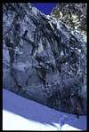
Retrace the last 200m of the route from BC in order to skirt below the avalanche and serac exposed zone below the hanging glacier on the E face of Kyajo Ri. Head back up hill to the W and attain the base of a 50m high rock band on its right hand edge. The rock band gives access to the foot of a glacier that rises to the S. Climb the rock band about 50m to the right of an obvious ice couloir. The easiest route zigzags through the rock in an overall right to left movement in two short pitches, making use of ledges and gently inclined corners. Sufficient protection is possible in rock cracks and around blocks. Climb the glacier to above the rimaye, initially by the rock covered right hand edge, later by the middle in order to avoid wide crevasses, crossing the occasional snow bridge. Aim for the foot of the mixed faced above the glacier that gives access to the col at 5550m defining the foot of the SE ridge of Kyajo Ri. The right hand side of the face (giving the most direct access to the col) is vertical and very compact. The route used begins some 120m to the left of the point closest to the col. A steep initial 15m up a slabby corner (difficult in poor snow conditions) leads to a gently rising terrace system that gives access over progressively easier terrain to the col. The whole traverse can be done in 2 long pitches of around 70m each. A good piton belay is possible atop a large boulder in the middle of the traverse - access to the boulder is problematic, and best made on its right hand edge on poor rock. Pitons and friends are essential to properly protect this traverse. From the col, make slightly descending traverse on verglaced rocks on the W side of the col in a NW direction to attain the edge of the highest serac of a small dying glacier. With care, and given favourable snow and serac conditions, the flat top of this serac can provide a comfortable camp site, relatively protected from the considerable rock fall occuring during the day on the S face of Kyajo Ri.
Camp2 to Summit:
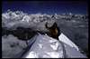
The easiest passage from Camp 2 to the summit begins by descending SW to the huge flat Kyajo Glacier, by the snow and boulder slopes just to the left of Camp 2 glacier. Once on Kyajo Glacier, head NW and follow the rock covered N edge of the glacier to the bottom of the ravine that separates Kyajo Ri from point 5925, and leads to the glacial col at 5700m marking the beginning of the SW ridge. Climb the ravine easily, keeping left to avoid potential serac fall, to the snow slopes of the col. From here the route is mostly on snow and ice. From the col the SW ridge rises at an average 50° in a fairly smooth sweep to the summit. Most of the remaining route is now visible. Follow the ridge NE, keeping mostly on the crest, passing through some steeper sections caused by constrictions between rocky outcrops. Rock belays are possible on the right every 50m to 100m, but on the first ascent the climbers moved together, using the occasional Deadman for protection. Much of the route is exposed to serac fall from small seracs lying very high on the ridge. Debris on the col is witness to this. The last section of the ridge (from 6100m) becomes somewhat steeper (55°) and sharper, and the climbing is more delicate with rocks a few inches below the surface. A significant rock outcrop defines the right hand edge of the ridge at this stage. Traverse right (60°) to the rock, at the level of an obvious ledge, some 15m above the lowest point. The summit is now reached in three long pitches. Traverse the outcrop to the right using the ledge and climb the moderately inclined snow slope on the right hand edge of the rock. The rock provides ample opportunity for good gear placements and belays. The belay at the end of the second pitch is only 15m below the high point of the rock outcrop. Continue more steeply to skirt the right hand edge of the top of the rock outcrop then once above the rocks tend left to gain the left hand arete defining the snow couloir that opens above and leads to the summit ridge. Follow the arete which merges into the summit slopes and continue to the summit ridge and summit shortly afterwards, a few metres to the left. On the day of the first ascent the summit was a narrow (40cm) ridge of snow separating the steep rocky S face from the very steep mixed NE face. It provides a fantastic unobstructed view of all the Khumbu summits, many of which it dominates, being the highest point in the Kyajo Ri massif.
Descent from Summit to Camp 2:
It is possible to retrace the same route used to climb to the summit. However, a shortcut can be made to avoid the ravine, and the long climb back up from Kyajo Glacier to Camp 2. The shortcut involves a 50m abseil from the S side of the rocks that define the S edge of the snowy SW ridge used for the ascent. Head for the last rock platform on the left of the SW ridge, some 150m above the 5700m col. Traverse a steepening boulder covered slope in an E direction as far as reasonably possible, in order to reduce the necessary abseil distance to the glacier below. Abseil down the mostly overhanging rock wall below to gain the glacier below. Traverse the glacier at the same level towards the SE and descend a gentle snow then rocky slope in the same direction until the top of steepening rock slabs. Head to the SW and descend a couple of steep steps. Contour the buttress below by a descending traverse to the right (some cairns) then to the left as soon as the terrain permits. Reach a shoulder from which the long traverse E to Camp 2 is now completely visible. Traverse to Camp 2 keeping more or less at the same altitude.
Descent from Camp 2 to Camp 1:
Regain the 5550m col. Descend to the glacier to the NE of the col in two 50m abseils, using the rocks to the right of the snow couloir for the second belay. Retrace the route to the top of the first rock band at the foot of the glacier. In one 50m abseil at its left edge regain the foot of the rocks and the end of the technical difficulties.
 |  |  |
Essential Gear
A couple of ice screws, 2 deadmen, a small rack of rocks/friends, a few pegs (lost arrows type), slings, 2 technical axes, 100m mountaineering rope, front-pointing crampons.