
-
 28186 Hits
-
 82.48% Score
-
 15 Votes
|
|
Canyon |
|---|---|
|
|
Canyoneering |
|
|
Overview
The Enchanted Gorge
Enchanted Gorge
Sequoia & Kings Canyon National Park
Sierra Nevada, California, USA
The Enchanted Gorge is a remote canyon in the heart of Kings Canyon National Park, Sierra Nevada, California. Perhaps due to its mystical name, the Enchanted Gorge has an allure that draws many backcountry travelers. Despite its disarming name, the Enchanted Gorge is not an easy trek. In his book The High Sierra: Peaks, Passes, and Trails, R. J. Secor states that the only thing "enchanted" about the Enchanted Gorge is its name.
Most who venture into the Enchanted Gorge would disagree, however. The Enchanted Gorge is perhaps the most remote canyon in the Sierra Nevada, giving the explorer a wonderful sense of isolation. The return trip up through Goddard Creek Canyon is spectacularly beautiful and serene, especially the upper reaches of the canyon. (Actually, Goddard Creek Canyon is much more spectacular than the Enchanted Gorge.)
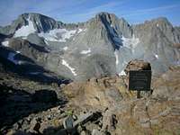
The Enchanted Gorge begins at 12,000 feet in the Ionian Basin at Chasm Lake. Disappearing Creek drops 4,000 feet from its origins at Chasm Lake to its confluence with Goddard Creek six miles down the canyon. The creek was so named because it frequently disappears under giant talus and snow pack. At the entrance to the Enchanted Gorge are two dark metavolcanic peaks named after mythological creatures from Homer's Odyssey: Scylla and Charybdis.
The Enchanted Gorge was named by Theodore Solomons after he and his partner E.C. Bonner traversed the gorge in 1851. They were attempting to establish a high route between Yosemite Valley and Kings Canyon, and it was the first recorded exploration of the gorge. Since then many other Sierra travelers have happily followed in their footsteps.
Geology of the Basins & Canyons

Granite & Metavolcanic Rocks in the Ionian Basin

Granite Benches in the Gorge

Metavolcanic Rock in the Gorge

Rhyolite in Lower Goddard Canyon

Granodiorite in Upper Goddard Canyon

Waterfalls Near the Confluence
All of the rocks in the area of the Enchanted Gorge are of igneous origin. The two basic type of igneous rocks found in this area are (1) granite and (2) metavolcanic rocks.
Granite, of course, is nothing more than crystallized magma. Deep plutons of magma cooled slowly over millions of years, allowing the minerals such as quartz and feldspar to crystallize into the Sierra granite that we know and love.
The metavolcanic rocks are volcanic sea beds that have been heavily metamorphosed. These ancient sea beds remind us that that the Sierra Nevada was once underwater off the west coast of North America.
GEOLOGY OF THE IONIAN BASIN
The Ionian Basin is almost entirely granitic. Most of the Ionian Basin is composed of a type of granite called alaskite. This granite is mostly feldspar and quartz, and owes its light color to a lack of dark minerals. This is the same granite that is found in the Evolution Basin and LeConte Canyon. The far western rim of the Ionian Basin is composed of a darker, sheared, finer-grained granite associated with Mount Goddard. The granite of the Goddard pendant contains many dikes.
GEOLOGY OF THE ENCHANTED GORGE
At the entrance to the Enchanted Gorge are three dark, jagged peaks that differ greatly in appearance from the granite peaks of the Ionian Basin: Scylla, Charybdis and the Three Sirens. These jagged peaks are composed of ancient volcanic sea beds that have been tilted almost vertically. The Enchanted Gorge and the high ridges on both sides are composed almost entirely of similar metavolcanic rock.
These rocks are mostly metamorphosed rhyolite (metarhyolite) and metamorphosed dacite tuff (metadacite). Rhyolite is a lightly-colored volcanic rock that contains a high proportion of glass (silica). Dacite is a darker volcanic rock that has a high iron content.
As you pass through the outlet of Chasm Lake you will notice a thin ribbon of metavolcanic rock on either side of the lake. However, once you pass the outlet of the lake and enter the Enchanted Gorge, you will travel on bedrock consisting of the granite of the Goddard pendant. (Much of this granite is obscured by the talus of metavolcanic rock that fell from cliffs above.) Further down the gorge you will down-climb numerous benches where the granite bedrock is readily apparent.
A large round lake marks the half-way point during your descent of the Enchanted Gorge. This lake also marks the transition point where the bedrock changes from granite to metavolcanic rock. In fact, the entire second-half of the Enchanted Gorge is composed entirely of metarhyolite, metadacite tuff and the associated talus. Here, the gorge becomes very narrow and you will get a close look at the metavolcanic rock. Just before you descend into the Goddard Creek drainage, the bedrock abruptly changes to a metarhyolite tuff.
There is one last interesting geologic note about the Enchanted Gorge. Although the gorge is V-shaped, it did contain a glacier during the last glaciation. Apparently metavolcanic rocks is rather soft.
GEOLOGY OF GODDARD CREEK CANYON
At the confluence of Disappearing Creek and Goddard Creek, look across the creek. It's all granite. In fact, the splendid granite that you see there is similar to the granite found on Cathedral Peak in Yosemite National Park. Just upstream are some spectacular waterfalls carved in granite.
Heading up Goddard Creek Canyon, you will leave behind the splendid granite and jump right into the metarhyolite tuff again. But don't despair, the wonderful Sierra granite is not far away. Climb up past numerous waterfalls about half-way up Goddard Canyon, and soon you will find yourself in the upper canyon surrounded by expansive granite slabs.
Actually, the rock in upper Goddard Creek Canyon is a granodiorite, not true granite. (Mount Reinstein is composed of the same granodiorite.) Granodiorite contains more plagioclase than feldspar, and often has a darker appearance than true granite.
Climbing up to the Ionian Basin, you will once again pass through metarhyolite tuff, metadacite and metarhyolite before encountering Goddard granite.
Getting There
There is no easy way to get to the Enchanted Gorge. The shortest and most-direct approach is from the town of Bishop in the Owens Valley. This approach will take two days and involves class-3 scrambling over the 13,000-foot Sierra Crest with your pack.
The approaches from the west (Fresno and the San Joaquin Valley) involve 20 to 25 miles of trail hiking and a few miles of cross-country to get into the Ionian Basin.
Alternative approaches involve crossing the Sierra Divide at lower-elevation passes (such as Bishop Pass) and then hiking two days up or down the John Muir Trail. Since there are so many options, I will discuss only the most direct approaches from the east (Bishop and the Owens Valley).
DIRECT EASTERN APPROACHES FROM THE OWENS VALLEY
Arguments abound regarding the best way to approach to the Ionian Basin from the Owens Valley. Proponents and antagonists argue over the relative difficulties of Haeckel Col, Wallace Col, Echo Col and even Lamarck Col. However, there does appear to be a consensus regarding Wallace Col: avoid it! Personally, I have never crossed Haeckel Col. But I have crossed Wallace Col, Echo Col and Lamarck Col several times, so I can speak for those passes from personal experience.
Haeckel Col, Wallace Col and Echo Col are all located in the same general area. From the Owens Valley, drive up to the trail head at Lake Sabrina above Bishop. Take the trail up the Middle Fork of Bishop Creek to Hungry Packer Lake. From there, you can cross the Sierra Divide via one of the three passes. All are arduous crossings, but Haeckel Col is reputedly the easiest of the three and you end up in the heart of the beautiful Evolution region.
Haeckel Col (class 3, 12,680+ feet)
Haeckel Col is reputed to be the easiest eastern route to the Ionian Basin. It is the pass north of Mount Haeckel. After climbing over the pass, you will be in the heart of the Evolution near Mount Huxley.
After crossing Haeckel Col, hike out to the John Muir Trail and head south to the vicinity of Wanda Lake. From there, Wanda Pass (12,400+ feet) is a popular route into the Ionian Basin.
Echo Col (Class 3, Elevation 12,400+ feet)
Echo Col is a moderately-difficult notch in the Sierra Crest that will get you to the John Muir Trail in the vicinity of Helen Lake, northwest of Muir Pass. Going through the col is serious class 3. We find it easiest to hand packs up and down when crossing through the notch, rather than trying to climb while wearing packs.
When approaching Echo Col from the Owens Valley side of the crest, look for the black rock on the right side of the cirque. Ascend the right side of the black rock to the notch (class 3) and descend the other side (class 3). Once over the col, you will have to traverse across benches to the vicinity of Muir Pass, and then cross over into the Ionian Basin.


Wallace Col (Class 2, Elevation 13,000+ feet)
Wallace Col is a very high pass that, like Haeckel Col, will drop you into the heart of the Evolution near Mount Huxley. The traverse from Owens Valley side of the Sierra Crest to the west side is a very tiresome slog up snow and loose scree. The reverse crossing is best left for the criminally insane. The west side of the pass is a vast unstable scree slope that would be utterly impossible to climb, especially with a pack. If Zeus needed an alternate location to torture Sisyphus, this would be the spot.
After crossing Wallace Col, hike out to the John Muir Trail and head south to the vicinity of Wanda Lake. Wanda Pass (12,400+ feet) is a convenient way to get from Wanda Lake to the Ionian Basin.


Lamarck Col (Class 2, Elevation 12,960+ feet)
Some people argue that the ease of hiking over Lamarck Col outweighs the additional distance one would need to hike from Darwin Canyon. This opinion certainly has its merits, especially when you measure the total distance from the trail head to the Ionian Basin.
From the North Lake trail head, hike up past Lower Lamarck Lake and climb up onto a bench. From there it is a long, long slog up to Lamarck Col. Perhaps because of the high altitude, it certainly feels longer and more difficult than it should be.


General Route Information

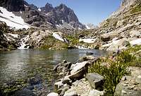
Chasm Lake

Talus Fields
The entire loop down the Enchanted Gorge and up Goddard Creek Canyon can be done in one long day if you travel light and are physically fit. However, if you are going through all that trouble to get over to the Enchanted Gorge, why not slow down and savor the experience? A two or three day loop from the Ionian Basin is much more memorable.
I definitely recommend doing down the Enchanted Gorge and up Goddard Creek Canyon, instead of vice versa. However, you can travel which ever route that you chose. You can even follow in the foot steps of Solomons and Bonner, continuing down Goddard Creek to the Middle Fork of the Kings River.
An early-season visit to the Enchanted Gorge allows you take advantage of the snow pack. You can travel quite fast and avoid a lot of unstable talus. However, you will have to deal with high water and dangerous snow bridges over Disappearing Creek.
Later in the season, when the snow it gone, you will spend a lot of time hiking on unstable scree and talus (ugh!). However, the creek will be much easier to cross at low water.
Descending the Enchanted Gorge
Ionian Basin

Hiking through benches

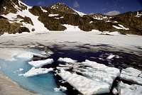
Halfway: A Large Round Lake

Breaking out of the chasm

The Lower Gorge
A descent of the Enchanted Gorge begins in the fabled Ionian Basin. This is an isolated lake basin ringed with a high ridge (as if the Enchanted Gorge wasn't isolated enough). If you climb onto this ridge via Wanda Pass, you will be rewarded with a view down into the Enchanted Gorge.
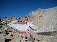
From Chasm Lake in the Ionian Basin, proceed to the outlet of the lake and follow Disappearing Creek down into the Enchanted Gorge. This section of the gorge is wide open fields of talus. Early in the season you will be able to glissade on snow fields.
After the talus fields you will encounter several benches separated by cliffs. You will have to pick your way down through the cliffs. Which side of the creek is best? There is no correct answer. One side may give you clear sailing for a while, but then you round a corner there is a cliff blocking your path.
About half-way down the gorge you will pass numerous tarns and one large, round lake. They are incredibly clear and green. It is worthwhile stopping and camping here. Why not slow down and savor a night in the heart of the Enchanted Gorge?
Deep in the middle of the Enchanted Gorge the walls close in and things can get challenging. Early in the season (i.e., through July) Disappearing Creek is covered by a thick snow pack (avalanche debris from the winter's snow fall). The snow permits rapid travel down the gorge, but beware of thin snow bridges! Later in the season when the snow is gone, good luck! You will have to find your way around the cliffs and the creek.
Once you break out of the narrow chasm, the gradient of the creek flattens and the valley floor is filled with cobble stones and brush. Here it is probably easiest to travel on the east side of the creek, but you had better get back on the west side of Disappearing Creek for the final descent to Goddard Creek. If the creek is running so high as to prevent you from portaging across the creek, you will have to stay on the west side.
On the west side of the creek, there are cliffs that repeatedly force you to bush whack high above the creek. Then another cliff will force you back down to the creek. You will climb up and down, up and down, thrashing through brush and briar the entire time. Oh yeah, watch for the stinging nettle! Did I mention the need for plenty of good antiseptic for all of your scratches?
The final drop to Goddard Creek is extremely steep. There are cliffs on the east side of Disappearing Creek, so make the final descent on the west side. In fact, if you stay high and "cut the corner" as you make the turn north into Goddard Canyon, you can avoid the steepest slopes. Take a good look at the topo map.
The confluence of Disappearing Creek and Goddard Creek is a beautiful area, surrounded by high granite cliffs and waterfalls. Take a rest here, enjoy the scenery, swat mosquitoes and lick your wounds.
Return Up Goddard Creek Canyon

Goddard Canyon

Goddard Canyon

Upper Goddard Canyon
If you thought the descent of the Enchanted Gorge was beautiful, just wait until you start the return trip up Goddard Creek Canyon. The higher you get up Goddard Creek Canyon, the more magical your journey becomes.
For the return trip up Goddard Creek Canyon, it is definitely best to stay on the east side of the creek, at least initially. You will traverse some very steep hill sides, but the views of the waterfalls on the west side of the canyon are spectacular. There are some reports of henous bush whacking on the west side of Goddard Creek. Not that the bush whacking on the east side of the creek is any fun! Besides, there is a creek on the west side that would be very difficult to cross at high water.
Before the steep ascent into upper Goddard Creek Canyon you will reach several large waterfalls. Bush whacking to get past these waterfalls is murderous. If you have never had the pleasure of bush whacking through manzanita, get ready for some real fun. Just dive in and take it like a man.
Finally you will climb into the upper reaches of Goddard Creek Canyon. This is a little-traveled alpine paradise. The high meadows are pristine -- please do your part to keep them that way. It is worthwhile to camp at the head of Goddard Canyon at Lake 10,212 feet. Why rush through such a paradise?
Hazards

Snow Bridge

Dangerous Snow Bridge
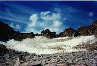
The most serious hazards in the Enchanted Gorge are the snow bridges over the creek. Be extremely careful where you walk. A fall through a snow bridge can result in a fall into the creek below. Early in the season the torrents will wash you into ice tunnels under the snow pack. BEWARE!
Some of the bridges are 30 to 50 feet above the creek. We came across a 3-foot diameter hole in the snow pack. When we peered down into the hole we were terrified to see that we were looking 50 feet straight down into the creek from the roof of a huge undercut dome!
No Impact Camping
"Take nothing but pictures, leave nothing (not even footprints)"
The Enchanted Gorge and Goddard Creek Canyon are fairly pristine by Sierra Nevada standards. Everyone who travels through these areas should do their part to keep it pristine. Specifically, what can you do to minimize your impact?
1. Walk on rocks or slabs whenever possible
2. Avoid walking through meadows
3. Avoid wet or muddy areas.
4. Camp on sand or rock slabs instead of vegetation
5. Where camp fires are permitted, build small fires
6. Bury the charcoal and blackened rocks (or dispose of them in the creek)
7. Do not build anything like walls, cairns, fire rings or shelters.
8. Always return your camp area to its natural state
9. Dismantle all man-made structures that you find
Adminstrative Remarks
If you would like to adopt this page, or have suggestions for change, please feel free to contact me.
Red Tape
Red tape is the same as that for Sequoia/Kings Canyon National Park
External Links
Leave No Trace, Center for Outdoor Ethics
Leave No Trace
Enchanted Gorge trip reports and photos:
https://garrettheonion.blogspot.com/2009/09/enchanted-gorge-trip-details.html
http://www.jeannepanek.com/mountains-and-musings/enchanted-gorge
http://www.lancesimms.com/Hikes/EnchantedGorgeHikeGPS2.html
http://www.climber.org/TripReports/1995/43.html
http://www.sierrahiker.com/EnchantedGorge/index.html
Bob Burd - Aug 22, 2009 2:44 am - Hasn't voted
Echo Col"Echo Col is a moderately-difficult notch in the Sierra Crest that will get you to the John Muir Trail in the vicinity of Martha Lake, northwest of Muir Pass." Martha Lake isn't really anywhere near Echo Col. Perhaps you meant Helen Lake? Also, you will then be NE of Muir Pass, not northwest.
Sierra Ledge Rat - Aug 27, 2009 10:39 pm - Hasn't voted
Re: Echo ColYES! Thank you! I'll fix that!!!!!!
sekihiker - Aug 16, 2016 7:41 pm - Hasn't voted
Two links that no longer workPlease delete these links. http://cvip.fresno.com/~jwf16/engor.html http://sierrahiker.home.comcast.net/~sierrahiker/EnchantedGorge/index.html The report is now at: http://www.sierrahiker.com/EnchantedGorge/index.html
Sierra Ledge Rat - Aug 16, 2016 8:09 pm - Hasn't voted
Re: Two links that no longer workThanks!
sekihiker - Aug 15, 2019 11:21 am - Hasn't voted
Goddard Canyon vs. Goddard Creek CanyonI hope this is not quibbling, but the Goddard Canyon mentioned in this report is actually Goddard Creek Canyon, which contains Goddard Creek. Goddard Canyon is northwest of Goddard Creek Canyon and contains the South Fork of the San Joaquin River.
sekihiker - Aug 15, 2019 12:52 pm - Hasn't voted
additional referencesHere are several more references which I consider to be worthy of inclusion: http://www.jeannepanek.com/mountains-and-musings/enchanted-gorge http://www.highsierratopix.com/community/viewtopic.php?f=1&t=4775&p=29070&hilit=Enchanted+Gorge#p29070 Phil Arnot, 1996, The High Sierra: John Muir's Range of Light
sekihiker - Aug 15, 2019 3:13 pm - Hasn't voted
Trip Report from an Ultramarathonerhttps://garrettheonion.blogspot.com/2009/09/enchanted-gorge-trip-details.html
Sierra Ledge Rat - Aug 22, 2019 3:08 am - Hasn't voted
Re: Trip Report from an UltramarathonerFixed!