
-
 7292 Hits
-
 81.08% Score
-
 13 Votes
|
|
Canyon |
|---|---|
|
|
36.83662°N / 117.16438°E |
|
|
Hiking, Scrambling |
|
|
Spring, Fall, Winter |
|
|
Overview

Larger than some states, Death Valley National Park is home to numerous canyons that beckon the curious and the intrepid. Most do not have official names. Many are technical. A few are named and hiker-friendly while also sporting interesting narrows and dryfalls that make them worth seeing. Fall Canyon is in that last category.
Fall Canyon is no secret but is overshadowed by its well-known neighbor Titus Canyon, through which many people drive. Just a short hike north from the mouth of Titus Canyon is the mouth of Fall Canyon, though, and it offers equally good scenery without the noise and the danger of being run over as you round a bend in the narrows!
Only a little bit of easy scrambling is required to reach the narrows, so this is a canyon suited to nearly all ages and ability levels.
Note: the next two canyons north of Fall Canyon, Red Wall Canyon and Palmer Canyon, are supposed to be even more spectacular (and more isolated). The latter has several nice sections of narrows and also has an 80' dryfall over a red cliff.
Getting There
18 miles south of the junction for Grapevine and Scotty's Castle and 15 miles north of the junction with CA 190, turn east onto the signed unpaved road for Titus Canyon and drive about three miles to the parking area. Vehicular traffic through Titus Canyon is one-way only and from the east. The drive through the canyon is worth it for mountain views, petroglyphs, a ghost town, and the polished walls of the narrows. From Beatty, NV, drive west for about 6.5 miles to the signed turnoff. It is then 26 miles on a dirt road to pavement again. High clearance is recommended, and the road is washboarded in places, especially before Red Pass and the descent into Titus Canyon, but in dry conditions, the road is passable for most passenger vehicles. It is highly advisable to check on road conditions before heading out, though.Route
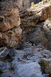
From the parking area, head north on a trail past the pit toilet (which you won't appreciate being downwind of) and hike for 10 or 15 minutes until you drop into the wash of Fall Canyon. Then just head "upstream" on the gravel. The canyon walls quickly become high, but the canyon mostly stays quite open. There are, however, some interesting-looking side canyons. One branching left as one heads upstream narrows and ends in a two-step dryfall. This canyon junction is where a high, island-like outcrop stands in the main wash.About 2.9 miles from the trailhead is a dryfall just beyond where the canyon finally tightens into true narrows. Climbing this dryfall, which is about 15-20' high, looks difficult but not impossible. However, if you backtrack to before the start of the narrows and look to the south side of the wash, you will see a cairned trail (see photo below). At first, the trail climbs steeply and has some Class 3 spots, but it soon levels out and then parallels the canyon, dropping back into the wash just above the dryfall.
 |
 |
 |
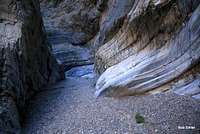
Beyond that point, the canyon features a nice section of narrows for about a mile before opening up again. Smaller sections of narrows appear after that first one, but the first one is the highlight.
 |
 |
 |
Maps show Fall Canyon continuing for several miles into the Grapevine Mountains. Almost undoubtedly, there are more narrows and dryfalls waiting for the curious and the intrepid. Most people seem to turn around shortly after the first nice section of narrows.

Red Tape
If approaching from Furnace Creek or Stovepipe Wells, you are supposed to stop at a self-pay station or a ranger station to pay the park entrance fee, which in 2012 was $20 for seven days. More details about pass options can be found using the link on this page to the park website.If you are approaching from the north via Big Pine or Scotty's Castle, you will have to go through a fee station at Grapevine.
Otherwise, there is no red tape, but one should be aware of park regulations (see website link).
Camping
Backcountry camping is free, as are the permits for it. It's so dry in Death Valley that camping in the wash is usually perfectly safe, but if there is any threat of rain then only camp on higher ground in the canyon or do not camp in it at all.There is a campground at Mesquite Spring about 20 miles north, at Stovepipe Wells about 25 miles south, and in the Furnace Creek area about 34 miles southeast. Note: in April 2012, the Furnace Creek Campground was closed. I do not know why or for how long. The Sunset and Texas Spring campgrounds were open.
Also note that camping is not allowed along the Titus Canyon Road.
External Links
NPS site for Death ValleyForum for Death Valley National Park