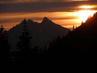
Cascade Volcanoes
Seems like everyone has their tick list and I have never really understood that whole thing. I always just wanted to climb things I thought were neat or scenic or cool-looking. That’s why I do just as much hiking as rock climbing as alpine mountaineering as scrambling as whatever. Being out in a beautiful place enjoying nature and the outdoors is way more important to me than any prominence, county high point, state high point, geocache list-checking could ever be. The only “list” I was ever interested in were the Cascade volcanoes mentioned in the “Climbing the Cascade Volcanoes” book by Jeff Smoot. I’ve since come to the belief that there should be a few additions to his list (Diamond Peak and Garibaldi-although I hear earlier editions of his book had Garibaldi in there) but as far as the book went, I really wanted to summit every peak in there.
I started climbing these in 2001 and finally completed the “list” when I dealt with the mileage of Glacier Peak this summer. Back when I moved to Oregon in 2000, my only ambitions were to really get into rock climbing and whitewater kayaking. The kayaking never happened (well, I bought a sea kayak and have enjoyed that) but I was lucky enough to be introduced to
through work and we soon started going to Portland Rock Gym. Then they took me to Smith Rock, Flagstone, Beacon Rock (and eventually to places like Yosemite, City of Rocks, etc.) to get on real rock.
Well, one day Mark and I were admiring Mt. Hood from Portland and he said those fateful words, “You know, there is an easy way up that mountain?” I had not even considered that but was intrigued. That is actually how I found Summitpost as I was researching this “easy way” up Mt. Hood. I gathered all the information and Mark and I set out one May night in 2001, only to be thwarted by many things. I had relatively new boots that blistered up my feet, I had no trekking poles at the time so my back was killing me under my heavy pack and we ran into 60-70 mph winds at Triangle Moraine. We roped up (I still am not sure why) and the rope was held horizontal in the wind. I actually got knocked over a couple times and had to self-arrest or be carried down to the White River Glacier (maybe that’s why we roped up?).
I learned a lot, mostly that I needed to be in better shape. I spent a month doing smaller hikes to increase my leg strength and endurance, and Mark and I went back and summitted 6/16/01. The sense of accomplishment I got from standing on the summit was amazing, and I was hooked. We looked at the line of volcanoes stretching south in the morning sun and I asked what they were…………..
A month later, I was invited to join friends on Three Fingered Jack. I was nervous about this one as it was going to be a technical rock climb. We slept at the trailhead and left early the next morning. We spent some time bushwhacking through shrubs up onto the ridge but once up there, the hiking was easier. Rain came, then hail and winds. Mark and his wife Natasha turned back but I went on with their friend, Vince. Vince is one of the more solid climbers I’ve ever met and we were halfway across the Crawl before he even noticed it. He asked if I wanted to be roped up and I assured him I did. I don’t remember much about the Crawl except hugging a bulging rock a lot. I must have looked like I was trying to get inside of it via a bear hug. We had no pro with us so, for the summit chimney, I belayed Vince from around a rock while he led it. He had no issues and soon after, I was belayed up to the summit in pea soup skies.
Of course, at this point, I was determined to do all of the volcanoes. But, I still didn’t have a huge circle of climbing friends for anything technical so I set about doing everything I could do solo. I hiked up Mt. Bachelor about 3 weeks later. A week later I did McLoughlin (still one of my favorites although I can’t explain why, just a neat place). Later that summer I also did South and Middle Sister.
I did St. Helens in November (during the no-fee part of the year). Enjoyed beautiful sunshine all the way up to within about 300 feet from the crater rim. Then, one of those storms you hear about rolling in within seconds actually did. I was in complete white-out before I could do anything. I don’t know where it came from but I could see my feet and that was about it. I got a real sick feeling in my stomach but decided to try to quickly tag the summit and bail. I did get there; at least I think I did. I got to where I didn’t want to go any further for fear I was walking over the crater lip, then I crab-walked back down until I got off slushy snow and onto ashy scree. I still wondered if I was going to find my way out of there. I took a few minutes to compose myself, worked my way down a bit until I finally saw the trail posts and after that I was good.
In 2002, I continued trying to bag the easy ones. I met a fellow summitposter for the first time on an Adams attempt over Memorial Day weekend but slushy snow and the extra long approach at that time of year made it too long to do in the time we had so we bailed. I then did Diamond Peak solo (well, with a few million mosquitoes) in July.
In August of that year I did Washington with friends and I remember lying in the sun on the summit for like an hour not wanting to leave. I felt like a baby spider on the long rappel there like when they balloon on their web strands across the yard at home. Whee!
One week later, I had a birthday 3-bagger weekend and one of the peaks I did solo was Thielsen. I completed Adams on my second attempt Labor Day 2002 with a buddy who was having a birthday. I remember him saying he needed his morning coffee so bad he put coffee grounds in a Nalgene with cold glacier water and called it good, drinking on that all morning. Also did Broken Top a week later.
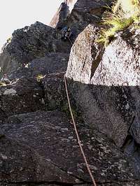
In 2003, I started doing different routes on Hood including Reid Headwall, Sunshine Route, Old Chute (now the standard route). Did the Steel Cliff Gullies Route but bailed down Wy’East as we had gone too slow. I remember the first technical pitch watching the “rock” ooze down in from of my eyes. And the snow was about 3 feet deep but melted out underneath so lots of post-holing on 40 degree snow. It took forever but I remember I placed my first piton and liked that “ring” it had when it went it correctly. I also remember walking over the ridge and finding sulphur vents up top and some sort of lichen growing around it. Was weird. Steel Cliff Gullies Route, photo by dkantola
But the Leuthold Couloir remains a mystery to me. Have tried this about 7 times from 2005 to 2010. Have been up just below the Hourglass and each time heavy ice or rock fall drives us back. One time my climbing partner caught a rock in his arm that ripped through his shell and all the layers he had on leaving a bleeding gash in his arm. One of these days conditions will be right and I’ll finally complete this route.
In 2003 I did Shasta but rolled my ankle causing an avulsion fracture that stopped me from bagging any volcanoes other than Lassen on a trip to Yosemite. I was recovering from the injury and actually got passed by an old woman on the trail everyone was calling “Granny.” Big ego boost there.
The following year, 2004, I was getting down to the tougher ones to complete so things slow down from here. I knocked off Jefferson in August with a bunch of other SP’ers. Was a nice climb. We ran a running belay across the traverse and then the summit pinnacle was easier rock than I expected. I led a short 15 foot easy 5th class pitch to the summit. When it came time to leave, we rapped down but the rope got stuck. In my efforts to pull it down, I discovered around a rock that there was an easy 3rd class option to the summit. Oh well.
About a month later, I did the Easton Route on Baker. Lots of crevasses and weaving in and out but over all it was straight forward. Man, I remember that drive back after that one going deep into the night and sleeping for an hour or so in a rest stop on the way to Portland.
2005 saw a winter attempt on Rainier for me up the Ingraham. We got to about 13,000 feet before my toes were scaring me they were so cold. I did not have plastics at the time and I don’t know what I was thinking attempting that in winter in leathers. Live and learn. I felt bad about causing us to turn back but what can you do?
North Sister was completed in June. That one was a mini-epic. We had a group of 5 and picked up another guy on the way up whose buddies had turned back. He turned out to be better than anyone in our group. But we had two large rope teams so it took forever to do the traverse in the snow to the Bowling Alley. Once there, a fixed line was set up. It was steep ice and snow but we all made it. On top, a storm rolled in and then with 6 of us rapping, it was super slow. Then the ropes got stuck. It just took forever. Then the guy who we picked up on the climb took a lead fall on the traverse back in the slushy and melting snow. He self-arrested but I remember hearing “Falling!” just as I was rounding the corner on the traverse and feeling really exposed. It was almost 24 hours before we were back at camp on the Collier.
Terrible Traverse on North Sister, photo by Dennis Poulin
I had planned on being back at my girlfriend’s house by then so a few of us trudged directly out from there to the car while about half of the group stayed behind to camp another night. I remember getting ahold of her 10 minutes before my “call the sheriff” time.
In August, I went back and did Rainier via the DC Route. It was really warm and I figured I didn’t need a sleeping bag, I would just lay in a bivy sack. You would think I would learn by now or at least start limiting the way things can go wrong. Anyway, it turned out to be pretty cold that night at Camp Muir. I got no sleep and shivered in my bivy sack with the rope wrapped around me for some kind of warmth. Then my sleeping pad deflated. Awesome! I was happy when midnight came around to get up and move. What a summit. 9000 foot climb.
2006 saw some attempts on Leuthold Couloir (previously mentioned) on Hood but no new volcano summits. In 2007 there were more and I also did a winter climb on St. Helens. In 2007 I also got married and climbing as I know it changed. I still was climbing but we also went on a honeymoon and were in the process of trying to move. Anyway, life interfered with any new ones. I knew there was one more left, Glacier Peak. And that approach was daunting. Almost 40 miles. Ouch. I was still trying Leuthold off and on but no real opportunity presented itself for me to knock that final one off. Until 2010.
Most every year around my birthday in late August, I’ll take a long weekend and do one or several climbs. My only wish for 2010 was to set aside one day and do Glacier Peak in 3 days. Karl had done it a couple years before and he downloaded his maps and track into my GPS (thanks!). It would prove to be a good move.
After emailing those that I thought would be interested, we had assembled a group of 4: myself, friend Ian, another buddy Steve (whom I met in an Expedition Training course through Timberline Mountain Guides in 2002) and Steve’s son Alec (who was about 7 or 8 when I met him while heading out on some climb with Steve in the early 2000’s, now 15).
Thursday night, August 19th, I made the drive to Seattle to stay at Ian’s before heading to the trailhead the next day. I had instructed everyone to be at the trailhead in time to be on the trail by 7 am. I wanted to take it easy and do the 10 miles to camp slowly so we were all fresh for summit day. Ian is a former guide and professional photographer who now does some work at a climbing store in Seattle. We definitely left on time for the trailhead but headed up the Mountain Loop Highway from the south end. In Verlot, we ran into a sign indicating the road was closed ahead. So, after calling Steve and letting him know, we had to go all the way back around and over the north road in. Suffice it to say, we did not get started hiking until about 9:15 am that day.
The hike in is beautiful and easy. The first 6 miles are relatively flat and through old growth forests. The firs are so big, their bark gets reddish and you would swear they were redwoods. The cedars are monsters. It’s a great hike to the Mackinaw Shelter and then you hit the switchbacks.
![Sun-dappled hike on Glacier Peak]()
Actually, the switchbacks are not that bad. There are 26 of them if anyone is counting and they go in and out of the forests and a slide area with views up to the meadows above. They also start providing views of Sloan Peak and Bedal Peak early.
![Indian Head]()
![Golden Eagle]()
But at one point, we heard a roaring sound in the valley below. We scanned around and saw three fighter jets coming north up the valley below us. The noise got louder and two of them screamed past us down in the valley. It was so loud we could not hear each other speak. The third jet banked left and went over White Pass. They looked to me like the same jets that Blue Angels fly; I think they are F-18’s. Steve said that there was a naval base on Whidbey Island in the Sound so we wondered if they were headed there. It would not be our last encounter with fighter jets this trip.
My wife, from Germany, worked on a US Army base in Germany when she was younger, and always said that the sound of US fighter jets is the sound of freedom. I wish she would have been there to see and hear that. It was our own private air show, well worth the price of 26 switchbacks.
We continued on to White Pass and into the pond and stream-filled meadows there. We set up camp; Alec tended his blisters (new boots), filtered water and ate. The sunset over Sloan and Bedal was a bright orange ![Sunset over Bedal]()
I’m not sure what time we actually set out, somewhere around 5 am I think after everyone got up and going. The traverse below White Mountain went fairly quickly. We lost the trail in the correct spot as, after looking around we could see we were where we needed to head north to the notch over to the valley where the White Chuck Glacier once was. We rested and had some food just before the notch and then we headed down into the valley.
![Walking On The Moon]()
The first part of the valley is a granite block-filled basin. The last of the White Chuck Glacier comes down from the right in between rock buttresses and we skirted that up and over another ridge. From there, things get more, well, lunar. ![In the boulders]()
This next area had some more ridges coming down from the right but it was all a mix of rock types with more volcanic stuff mixed in. There was little or no grass and the erratics left behind were huge. Like truck-sized. Little pond and lakes dot the area from the melt. The feeling is other-worldly, like you are on one of those odd planets from Star Trek but none of these rocks are paper mache, there would be no lifting them and throwing at walking lizards today.
It took a while to get up and over these ridges. Some snowfields here and there, loose rock in mush mud, streams to jump, up and down. I began to see why there is a High Camp now as this takes a lot longer than it looks on a map. We got a bit too far right, thinking we could shorten the route through this and ended up going really slowly up a steeper ridge. But it worked and put us close to High Camp on a small plateau where we took our next rest.
![Getting to the Gerdine]()
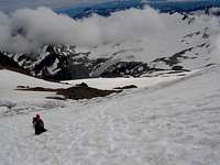
The trail led to a nice spot to get onto the glacier just before a gendarme that would have been dicey to scramble. So, we donned crampons and harnesses and roped up into two teams. Steve and Alec on one rope, Ian and I on the other. I led out and we bopped up and over the undulations of the glacier. No crevasses here, nothing very steep, just cruising up. It gets a little steeper before you cross to the Cool Glacier but nothing much.
![Rest Stop]()
![Crevasses on the Cool Glacier]()
Crossing over the glaciers, there is a short section with crevasses as the ice was twisted between the two. Some jump-steps and a few pulls on the axe gets one across pretty easily. From there, you can see the rest of the glacier climb up to the summit ridge. There was some weaving around some lateral crevasses, all very basic stuff. The angle was not very steep. The hardest part of this was exiting the Cool Glacier and climbing up the graham cracker pile of dust onto the ridge. It was also at this point, we lost half the team.
Steve and Alec were slow getting up to us and when they got there. Steve felt they were slowing down too much and we could now see weather moving in from the west. It was 3 pm as well and we were still about 800 feet from the summit with another snowfield between. Steve made the call and we could see the disappointment in Alec’s face but I think he knew he was pretty beat too. They decided to head back down and we’d all meet up back at High Camp.
We never did exactly set a turn-back time which was probably a good thing in retrospect as I think Ian and I both would have thought we were past it. Regardless, we thought we could head up and tag it. Ian, who had been feeling really strong, and me with summit-fever, thinking to myself that I did not want to have to come back and do this approach again, headed up. However, we could now feel the altitude and were getting winded quicker. We just kept trudging up about 75 steps at a time, sucking air, 75 more steps, etc. We were soon (well, it seems like it was soon) at another steeper snowfield on the left side of the ridge. The rocks that looked scramble-able, now looked more technical so we’d have to hit the snow but we didn’t want to have to put crampons back on and take more time so we just hit the snow anyway. Ian went a bit left, I stayed closer to the rock in the middle and ended up getting onto it and chimneying up part way until that rock ran out. Then I kicked steps into the snow/ice to keep going. Ian hit the end of the snow first and went left and right trying to figure out which pile was the true summit. ![Summit and Weather]()
![Heading back down]()
We went back the way Ian had come up which was easier going down. We did put on crampons on the way down and it definitely helped. To our surprise, once we got back onto the rock ridge, we could see a group of about 8 coming up behind us. We talked with them a bit and they said they were camped in our area. They all headed up and we wished them well.
Once back down on the Cool Glacier, my trusty crampons that I’ve used for 9 years finally let me down (well, a little). The anti-balling plate on my right crampons that I’d been nursing along finally snapped from years of abuse and I had to tap the snow out of it about every 2 steps. This made the descent extremely slow and laborious. Ex-tre-mel-ely sloooooooooooooow………………![Clouds on the ridge]()
However, we did make it back to the ridge and I was glad to take the crampons off. Once on the ridge, the weather hit us with winds and clouds. I could not hear Ian who was now a bit ahead of me and at times, his image vanished from view, only to reappear as the clouds skipped along the ground. We went really fast through here and were down on the snowfield, up and over, and back at High Camp where Steve and Alec were hanging out.
We did not waste time getting out of there, knowing how much light we had left. We went lower in the valley on the way out and then due south over the ridges and boulders and more ridges and boulders racing the lowering clouds until darkness caught up with us. We kept going, only slower, making sure to stick together. It was about this time that a whole bunch of headlamps came down on us from up higher on the left. It was the large group that went past us on our way down from the summit and they were moving really fast. They passed us up, saying hello, but were off ahead of us in no time.
We ended up going a little higher than expected and discovered we were on a glacier with small crevasses. It was the edge of what was left of the White Chuck Glacier. We could see the headlamps of the other party below us so we headed down that way too. We caught up with them taking a break on the edge of the glacier and a swampy area. They warned us of the swampy area and Ian noted it too. Then they were off again. We decided to follow them, not sure why. Mostly they just seemed to really know the terrain and were moving fast. I led out and did my best to keep up with them and we did for a short while. Two of their group were behind us for a bit then passed us up (this would be a note for later). We did our best to keep up with them but they kept getting farther into the night ahead of us. These guys had summitted an hour after us, beaten us back here and were pulling away. I looked at Ian and asked “Are they robots? They don’t get tired.”
Eventually though, they vanished into the descending fog and gloom and we were alone again. We got back to what we thought was the ridge heading over the notch back to the trail to White Pass, however, when we crested the ridge and then started down the other side, things were not like they were coming over. We were still descending granite boulders and loose stuff with grass instead of the more volcanic choss on the other side of the Notch. We all sort of wandered around trying to see if something looked familiar. It did not. I broke out the GPS and it seemed we were a bit south of where we should be, like we shouldn’t be on the other side of the Notch yet. Now, we were getting cold and were in mostly white out conditions. Everyone was kind of having their own ideas on what we should do and they were all different. I was just getting ready to start digging for my Emergency blanket to bivy down until morning when the guide in Ian came out and suggested we just get our parkas on and take a few minutes to settle down.
We turned off our headlamps to see if we could get a better view as the light was just reflecting off all the fog causing us to not see more than about 10 feet around us. There was a small break in the fog that we couldn’t have seen otherwise and it appeared the Notch was up and to our left (where it shouldn’t be according to our thinking). I got the GPS out again and Ian and I compared it to the topo map. Everything lined up and told us we needed to go left where we saw that break in the rock above. It didn’t seem right but we all know in situations like this, you must trust the technology and equipment. Having no visibility plays tricks with your head and bearings and we knew what we had to do now. As soon as we started heading that way, we found the other group’s footprints and a climbers path up to the Notch. When we crested the ridge, we saw the cairn and way we had come up in the morning. From there, it was an easy descent down and around to the Notch, then another up and over a ridge until we were back to the trail to White Pass. Except there was no trail where there should be.
Back out the GPS came and we faithfully followed it again LEFT, where nobody wanted to go, and it took us right to the trail. Once we were back on the trail, Ian declared we owed Karl a beer for providing us with his track and maps.
We had another few miles to go to camp and it was 1 am when we arrived. We had not eaten in a while but we were all half comatose from being on the move for 20 hours and we all just went to our bivy sacks and started snoring. I was woken up about a half hour later by the sound of rain 6 inches from my face bouncing off the nylon. I quickly pulled out my shell jacket and draped it over my backpack as I did not want a wet, heavy pack for the hike out the next day. Then it was off to dreamland.
It rained on and off that night and I woke up early to see Steve in his bivy sack hunched up muttering “cramp!” Alec was already up and looking around. I took advantage of a break in the rain to put my stuff under a tree in a dry spot and started packing up. My feet were pretty sore and I was going to head out ahead of the group as I was moving slower than them. My liner socks had gunked up from sweat, grime and mushy moleskin and had hardened causing big open sores on both sides of my ankles. I was not looking forward to the 10 miles out but knew I also had a 3 hour drive home longer than the others too.
So, I cut out a half hour or so sooner than the rest and met up with a climber on the trail from the group that had passed us in the night before. It appeared they had hiked in and got to White Pass after we left in the morning to summit, dropped their gear and kept going in one push to the summit. When they got back to White Pass an hour or two (or three) ahead of us, they must have set up camp then. Now they were bugging out earlier than us too. Robots! ;- )
I started chatting with this guy and he informed me that there were two in their group that had done this climb a number of times and really knew the area well. He also mentioned that he was one of the two that were behind us for a bit and then pulled away to catch up with their group. The other guy with him had some sort of nerve problem in his foot that caused pain with every step down so they were going really slow. I thought about this for a bit and then realized some guy with a foot injury was faster than all in our group. I felt old and pathetic but what the heck, I had just finished up the only sort of list I had ever thought about completing. It took me 9 years but whatever.
So, I hobbled out that day in the rain. Ian caught up with me in the switchbacks and then I met him again at Mackinaw Shelter where we waited for Steve and Alec. I then headed out first again and Ian caught me with about 2 miles to go. Back at the trailhead, we waited a bit for Steve and Alec but they did not show so I left a note on their car explaining that I wanted to get back to Portland before midnight so we were heading out.
And yes, it was a long drive back that night to Portland with a lot of caffeine and loud music. As it should be.


Comments
Post a Comment