
|
|
Mountain/Rock |
|---|---|
|
|
38.84600°N / 120.057°W |
|
|
8363 ft / 2549 m |
|
|
Get Familiar! --- Overview
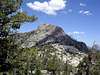
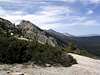
Flagpole Peak is certainly the most spectacular peak in the Echo Lakes basin, Lake Tahoe Region, California, even if it is a bit lower than some of it's more popular neighbors. Located on the ridge separating the Echo Lakes hanging valley from the main Lake Tahoe basin, Flagpole Peak offers superb rock climbing routes with a minimal approach. Views in this area are amazing, and Flagpole is no exception. Several peaks listed on SP are visible from the exposed summit, including Mt. Rose, Freel, Tallac, Ralston, and Pyramid.
Flagpole get climbed frequently, although there is no summit register. Evidence in the form of various clothing items tied to the "flagpole" placed on the top indicates that not all hikers return appropriately clad...
The summit is actually an exposed class 3 climb by the easiest route, with long drops on two of the block's three sides. Routes up to the crest will involve class 2-3 climbing, with any level of 5th class available should the regular routes be too boring. The granite is mostly very high quality, and several multi-pitch climbs have reportedly been established on the steep south-east ridge.
 |  |  |  |  |
Get There!
The trailhead for Flagpole consists of the Echo Lake trailhead and parking area. From US Hwy 50 in South Lake Tahoe, proceed to Echo Summit and look for a "Sno Park" turnoff just west of the now defunct "Little Norway" resort just 1.1 miles west of Echo Summit. This turnoff is Johnson Pass Road, and follow it back northeast 0.5 miles to Echo Lakes Road. Turn north and follow this road 1 mile back into the forest until the Echo Lakes parking area is reached. Start hiking from here, crossing the Echo Lake dam/outlet, and proceed north along the low ridge to Flagpole Peak.
 |  |  |
Get Legal! --- Red Tape
This peak is just outside the Desolation Wilderness, so no permits are required. If hiking into the Wilderness area later, be sure to get a self-issued permit at the kiosk down at the Echo Lake boat-launch ramp. Parking at the upper lot is free and seemingly time-unlimited.
Get Scheduled! --- When To Climb
This is a summertime climb, as the Desolation region tends to retain snow for a long time. Snow or ice accumulations on the granite slabs would make climbing quite annoying. Also, the road into the trailhead is closed for much of the winter.
Get the Goods! --- Lodging, Food, Gas
Camping in the Desolation Wilderness requires a small fee along with the permit. For the USFS land outside the Wilderness, call the Eldorado National Forest Information Center at (530) 644-6048 for more information.
Lodging, food, and gas is available in South Lake Tahoe just a few minutes away.
Get Lucky! --- Mountain Conditions
For current conditions, check out anything relating to the South Lake Tahoe or Desolation Wilderness areas.
Eldorado National Forest Information Center
(530) 644-6048
Open all week, 8:00 a.m. to 5:00 p.m.
(longer hours in the summertime)
Lake Tahoe Basin Management Unit
(530) 573-2694