OVERVIEW
Flat Top Mountain has been in my front yard for almost two years now. I have occasionally looked up to the top of the mountain and admired the height and prominance of the peak, but never looked into any specifics about the mountain. In fact, I didn't even know the name of the peak until I decided to hike it about a month ago. Needless to say, this mountain and this mountain range (Oquirrh Range) are overshadowed by the higher and more popular peaks that are around. Despite the fact that this mountain doesn't get much attention I was very pleased with my experience on the mountain. The reason we decided to Hike Flat Top is to complete the 6 of the 8 -5000K prominent peaks in Utah. The six that we have set out to summit are: Flat Top, Ibapah, Deseret, Timpanogos, Nebo, and Kings Peak. The two that we will be missing this summer are Mt Peale, and Mt. Ellen. If you would like to know more about the 8 5000K prominent peaks click on this link
https://www.summitpost.org/mountain/rock/153458/flat-top-mountain-ut.html. The author Dean describes the concept of prominence well and gives names and links to the Peaks.
Driving Directions
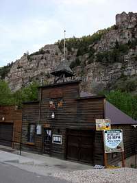
From I-15 take exit 279 (Lehi Main Street). From there you will head west bound on Highway 73. You will drive on this highway for close to thirty miles until you come to a sign that directs you to the town of Ophir (It will be on your right hand side). As you proceed up this canyon you will pass through the town of Ophir. If you are there during the hours of "quiet time"
![Ophir town hall]()
make sure to be polite. The town of Ophir is unique to say the least. The residents that live there are very lucky to be nestled in such a nice canyon and it is obvious that they realize their good fortune by the many many NO TRESPASSING signs posted throughout the town. As you pass through the town of Ophir you are looking for a road that heads up the canyon on your right hand side. This road is located right before a small dam in the river. If you continue up the road you will run into some campground sites and you will know to turn back because you have gone to far. I have read a few reports that this road had been blocked off, but we found it open and proceeded to drive up the road. I will mention that the road is very rocky and has a few technical driving sections. If you don't have a four wheel drive or don't feel comfortable driving in rough terrain then don't attempt to drive the road. The road goes for about 2.5 miles and while we were there the farmers were bringing their cows to graze on the mountain vegetation. So if you decide to hike the road instead of drive it then be prepared to have a multiple run-ins with some very large cattle. During the drive the road will fork once. Your natural compass will tell you to take a left at the fork, but be sure to stay right. The left will lead you to a dead end. As you near the 2.5 miles you will eventually come to a saddle on the mountain where the road diverts in three different directions. If you go straight it will lead you to the town of Mercer, if you go right it will take you up another peak, take the left fork. This will lead you up the hill a short distance where you will come to a clearing. This is where you park. We stacked a few rocks to mark the trailhead, but I am sure they will get knocked down easily so look for a pile of four rocks and this is where you start.
Trip Report
The main warning that I would like to shout out about hiking Flat Top peak is that the TRAIL IS HORRIBLE. If you are the type of hiker who enjoys some freedom off the trail and trailblazing your own way to the top then you will enjoy this hike, but if you like a well defined trail then this might not be the hike for you. Another suggestion would be to not wear shorts for this hike. Since a lot of trailblazing is involved, hiking in the brush composes much of the first part of the hike. I made the mistake of wearing shorts and my legs became very scratched and sensitive during the trip. The first part of the hike takes you up a series of switchbacks along the first hill. Once you loose site of your vehicle you will come to a saddle along side the top of a nole. This will give you a great view of the Oquirrh Range. I found this range to be very beautiful. I consider it a well kept secret since I feel that it gets overlooked by the more popular and accessible mountain ranges. The trail then leads you to a along the saddle of another hill before you make a small elevation drop into a small group of trees. This part of the trail becomes very difficult to stay on the "trail" As you exit the group of trees look for the trail heading up the hill. We made the mistake of taking a path that was headed down the hill and ended up having to backtrack. You will find some more switchbacks and then a long straight section that traverses the side of the mountain headed towards another saddle. Once you reach this saddle you will follow the ridgeline of the mountain all the way to the top of Lewiston Peak. I would recommend staying as close as possible to the top of the ridge so that it limits the amount of uphill climbing. If you only want to Summit Flat Top then you have the option of traversing across the North side of Lewiston and following the ridge up to Flat Top, or you could Summit Lewiston and then follow the ridge to Flat Top. I would recommend going to the top of Lewiston since it gives you a better idea of exactly where you need to go to reach Flat Top, it has a nice log book to sign, and the chance to summit two peaks in one trip is always fun. Once you reach the top of Lewiston you have a one mile hike to Summit Flat Top. We hiked it at the end of May and found ourselves Post holing in 4 foot deep snow all along the north face of Lewiston. If you are hiking it earlier I would recommend snow shoes. Once you reach Flat Top you will find a silver Mailbox
![Summit Flat Top Peak]()
and a solar powered shed (yeah, kind of weird). The view is great since you can see both Utah Valley and Salt Lake Valley and also out west clear into Nevada.
Wildlife spotted
I was bummed at the lack of wildlife that we spotted. I was expecting to see some deer or elk along the hike, but the most we saw was a mouse and a golden eagle. I will say though that as we were reaching the summit of Flat Top an unmanned military glider came very close to us, slowed down, took pictures and hummed right by
. It was so close that we probably could have hit it with a rock, but we were to busy taking video footage. I am assuming it came from Camp Williams, but you never know maybe the residents of Ophir are getting high tech and were checking up on us to make sure we weren't trespassing.
Special Notes and Reminders
Some things specific for this hike to remember would include:
1. Obey all of the "No Trespassing" signs posted. Comply with quiet time, don't trespass, and be nice to their cows. Some hikers in the past have mentioned that they have been threatened with arrest for trespassing onto private land.
2. Don't wear shorts. You will be hiking in brush for a good portion of the hike. Even when there is a trail it is very overgrown and hard to follow.
3. Bring enough water since there isn't a place to filter water during the hike.
4. Give yourself ample time. I felt like this hike was longer than the listed 4.5 miles.
5. In Hindsight I would try and summit very early and be back in the town of Ophir by early afternoon. They offer a tour of the old mining sites and their museum. The town you will find is quite charming and it could be fun to spend an afternoon there.
Enjoy!


Comments
Post a Comment