

|
|
Mountain/Rock |
|---|---|
|
|
47.56726°N / 12.29662°E |
|
|
Mountaineering, Trad Climbing, Sport Climbing |
|
|
Spring, Summer, Fall |
|
|
7175 ft / 2187 m |
|
|
Overview
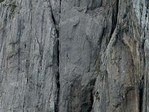
 The famous east face.
Fleischbank is an important summit containing a vast ocean of steep rock on the west side of the Steinere Rinne. It has been a famous rock climbing peak for at least 100 years. Especially impressive to me is the incredible 15 pitch East Wall route, first climbed in 1912 by Hans Dülfer and partner W. Schaarschmidt. I'm not sure to what degree they aided on pitons and what was climbed free, but judging by the many bold routes being put up in the Kaiser at that time, they climbed free to a high standard. Today that climb is rated UIAA VI, which is roughly 5.10 in the YDS system. That route has two technical traverse pitches, and two sustained pitches of 5.9 in the exit cracks. Truly, to look up at this wall from the Steinere Rinne is to be awestruck by these pioneers.
The mountain also contains extremely hard modern routes. Just imagine what these guys are climbing! I don't even know, but they are definitely pasted onto the tiniest of holds:
 Climbing on the east face.
First climbed in 1886 by Schöllhorn and Widauer.
Getting There
From the north (eg Munich): Travel south on the A8 and then the A93 to Austria until just before the Austrian border. Take the Oberaudorf/Niederaudorf exit and go east to Niederaudorf (which is in Austria). Continue east on the B-172, following signs to Walchsee and then turn right onto B-176 to pass the village of Schwendt. You'll reach the village of Griesenau, then turn right on the road up to the Griesener Alm. This is a toll road, but if (like me) you come very early in the morning and leave at night, no one is there. Park at the restaurant and hotel at the end of the road.From the south (eg Innsbruck): Travel northeast on the A12 towards Munich, taking the exit at Woergl to St. Johann in Tirol. When leaving the town on the north, take the side road towards Gasteig and Griesenau. From Griesenau, continue as above.
From the parking lot hike up the trail about 45 minutes to reach a junction. The main trail goes to the Stripsenjochhaus, visible above about 10 switchbacks. Turn onto the side trail going to the Steinere Rinne.
For north facing routes, Fleischbank is already mighty on your right, and you'll need to leave the trail soon on whatever climber's path suits your route. For example, the well-protected and popular "Via Classica" (V) is accessed by climbing scree up from the trail into the massive gully between Fleischbank and the Totenkirchl. The North Ridge is also popular, and should start in this area too, but I don't have firm details.
For technical east side routes, continue up into the Steinere Rinne, from which many routes are available on your right as you climb.
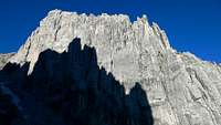
 View showing the summits of Fleischbank and Christaturm on the left, with Predigtstuhl and Hintere Goinger Halt in the center.
Red Tape
None. I've slept at the trailhead and there was no hassle.Camping
You could camp, though with only an hour or so to reach many routes, it's probably better to stay at the trailhead climber-style or get a room at the inn. At the very least, enjoy a dinner at the restaurant.External Links
Markus Stadler's great site with climbing route information.A very good PDF topo and description of Via Classica is here.
Also a very good description for the North Ridge here.
Some popular routes
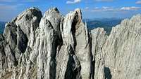 The Fleischbank and neighbor Christaturm.
- Normalweg (III) - the way of the first ascent in 1886, and the normal descent route.
- Dülfer (VI) - famous route on the east face, featuring some tough traverses. First climbed in 1912.
- Wiessner-Rossi (VI+) - another famous route on the east face.
- "Vertical Tango" (IX+) - a real testpiece...
- North Ridge (III+) - popular and scenic with a short approach.
- "Via Classica" (V) - well protected 15 pitch climb on the northwest side.
Getting down
From the summit, the typical way down is to follow the Normalweg (Normal way) in reverse. Go down and south in gullies occasionally marked by red spray paint (yes, I know, it sucks :-( ). You'll pass two abseil anchors. The first one is needless, but the second one might be useful to avoid a short vertical chimney downclimb under a chockstone (grade III).Now walk on trail to the Christascharte. Do not descend it, instead go up along red-marked trail to just below a steep cliff of the Hintere Karlspitze:
 Descent near the Christascharte
From here follow a trail for some distance down, rounding ribs of the Hintere Karlspitze. Then make 1 40 meter rappel or two 20 meter rappels from established anchors to reach a ledge. 3 more 20 meter rappels or 1 60 meter rappel will get you onto snow or scree below a massive gully. Helmet recommended here. There seem to be multiple rappel routes established here, perhaps because of overcrowding in the high season.