
-
 8409 Hits
-
 75.81% Score
-
 6 Votes
|
|
Mountain/Rock |
|---|---|
|
|
45.55250°N / 6.94680°E |
|
|
9612 ft / 2930 m |
|
|
Overview
The Pointe de la Foglietta (pronounce : "Folliett") dominates the new ski resort of Sainte Foy Tarentaise.
This summit is on the crest which spreads from the Pointe d'Archeboc (3272 m) on the french-italian border to the west.
Other summits of this crest :
- Pointe de l'Argentière (3053 m)
- Pointe des Lacs Verdet (2967 m)
- Pointe du Grand Soliet (2928 m)
- Rochers de Pierre d'Arbine (2647 m)
The north face of Foglietta is one of the best loved off-piste routes in the area, much favoured by local mountain guides because of the quality of the snow which lasts long after other routes have been skied-out.
Foglietta sometimes spelt Fogliettaz is an italian family name.
 |  |  |  |
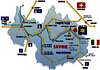
Getting There
1) Access to Sainte Foy Tarentaise
Road access :
Sainte Foy is an easy, 10-hour drive from the channel ports
• From Albertville, take the N90 dual carriageway to Moutiers, and on to Bourg Saint Maurice
• From Bourg, take the D902 towards Tignes and Val d'Isère.
• Pass through Sainte Foy village, to the village of La Thuile
• Turn left towards Sainte Foy station - the ski resort
• Information on road conditions and traffic can be found by calling Info route Savoie on
+33 4 79 37 73 37 or Info Route Rhône Alpes Auvergne on +33 4 72 81 57 33
By plane :
The nearest airports are
- Chambery (Buzz and charter flights)
- Lyon (Buzz, GO or national carriers)
- Geneva (Easyjet, Buzz and national carriers).
• Chambery is about 1½ hours by car, Lyon and Geneva are both 2½ hours by car, and all major car hire companies operate at the airports.
•Direct bus services are available from all three airports to Bourg Saint Maurice. Information from :
Geneva www.touriscar.net
Lyon www.satobus-alpes.com
Chambery Transneige +33 4 79 35 21 7
By train :
Eurostar run direct services from London to Bourg Saint Maurice on Friday night and Saturday. Information from www.eurostar.com or 0990 186 186
• Alternatively, take the Eurostar service to Paris or Lillourg Saint Maurice. Information from www.sncf.com or Rail Europe at www.raileurope.co.uk or 08705 848 848
• Buses are available to Sainte Foy village (information and reservations from Autocars Martin at www.autocars-martin.com
or +33 4 79 07 04 49 - English spoken), from where you can take the free shuttle bus to the ski resort (information from +33 4 79 06 95 19)
• Taxis will take you direct to the ski resort - approximate fare 38 euros. Call Gérard Arnaud
on +33 4 79 41 05 73
2) You can also reach Sainte Foy Tarentaise if you stay in the ski resorts Tignes or Val d'Isère
 |
Routes Overview
Pointe de Foglietta is a ski-mountain
1) Usual access over the SW ridge from Col de l'Aiguille
2) Ski descents :
- South face from the summit or from the Col de l'Aiguille to Le Clou and Le Monal with spectacular views across to the glaciers on Mont Pourri.
- North face : quality snow also late in spring. Descent to Le Crot and La Masure.
 |
Red Tape
No red tape
When To Climb
I recommend to climb on Pointe de Foglietta in winter or in spring : Foglietta is a ski-mountain with fabulous off piste routes with their stunning and unforgettable scenery
Camping
CAMPING LA VALLEE HAUTE * * *
Address : Renouveau Vallée
73700 Bourg Saint Maurice
Phone 04 79 07 18 07
Fax 04 79 07 20 95
Opening dates 20/12 - 30/04 & 15/06 - 04/09
Capacity 40
Altitude 840m
CAMPING LE VERSOYEN * * *
Address : Route des Arcs
73700 Bourg Saint Maurice
Phone 04 79 07 03 45
Fax 04 79 07 25 41
Opening dates 15/12 - 04/05 & 16/05 - 15/11
Capacity 200
Altitude 840m
Mountain Conditions
Mountain conditions : on the link page, choose Sainte Foy Tarentaise.
History of Sainte Foy Tarentaise
Archeological evidence leads us to believe that the lower Tarentaise valley could have been inhabited since 4000BC, whilst the climatic warming in 1000BC would have encouraged the populating of the upper Tarentaise valley.
The Romans called the inhabitants of the upper Tarentaise valley the "Acitavones", which seems to have been a derivative of the name "Ceutron". These would have been the ancestors of today's Santefèrains, as the residents of Sainte Foy are now known. In 218BC, legend has it that that Hannibal and his elephants and the Carthaginians would have passed close to Sainte Foy whilst crossing the Alps to fight the Romans on their home soil. Today, we are almost certain that the Romans themselves inhabited Sainte Foy.
Until the 18th century, the "commune" or borough of Sainte Foy extended as far as Tignes and the valley where the source of the Isère is to be found. Sainte Foy witnessed much conflict over the centuries, before settling into a more traditional, peaceful lifestyle until 1860 when it became part of France.
Many impoverished Santafèrains profited from this by leaving to sweep chimneys in the major cities, such as Paris, returning with substantial savings to re-establish themselves in their native land.
Sainte Foy was again subjected to the vagaries of war with the occupation of the Italians and Germans during World War 2, and afterwards finding a new lease of life through tourism.
The local economic risk caused by the exodus as a result of the abandonment of the traditional rural way of life in the 1960's led the local council to embark upon the ambitious project to create a winter sports resort accommodating 20,000 people.
Several potential sites were considered before "Bonconseil" at 1550m was selected in 1982. The project reached fruition in 1990 when the three 4-seater chair lifts were opened. These have been carefully sited to serve 25km of prepared runs up to an altitude of 2620m, and suitable for all levels of skier, with the potential for further development in the future.
The commune of Sainte Foy : geography
Few communes the size of Sainte Foy extend over such a vast area, or such a large difference in altitude. The commune covers over 11,000 hectares and spans a height difference of 2856m, from its lowest point at Viclaire at 890m to the summit of the Grande Sassière at 3746m.
It is bounded to the South by the river Isère (apart from a small area on the other side of the river), and to the north for 20 or so kilometers by the Italian border. This can be easily crossed by the two mountain passes, the Col du Mont and the Col du Rocher Blanc. To the east and west it is bounded by the "nants" (mountain streams) of Moulins and La Balme (or Nant Cruet).
Amongst the 100 or so hamlets that make up the commune is to be found Le Miroir (the mirror), a protected site. The origin of the name is debatable: some say it is a derivative of mourir (to die) reflecting the terrible epidemics and plagues that ravaged Europe in the Middle Ages. However, it is nicer to think that the beauty of this village, whose windows reflect the midday sun, earned it its pretty name. Le Miroir is renowned for it's colonnaded chalets, an attractive architectural feature with practical origins.
The use of such columns originated in the Italian Aosta valley. They support the roof overhang, which provides a covered area allowing dry air to circulate in the hay loft or wood store, and allowing the building's occupants to circulate from one floor to another sheltered from inclement weather.
(Traditionally, each floor had a different purpose: the lower floor would be occupied by animals, the middle floor by people, and the top floor used for storing hay, wood etc, so there were no internal staircases.) Such chalets can also be seen in La Mazure, Montalbert, Le Baptieu, La Thuile, and Bonconseil (now Sainte Foy ski resort).
Bread and ovens in high Tarentaise
The bread ovens were heated by pine wood fires for several reasons, but mainly because pine gives off no smell, and makes plenty of embers when burning. Naturally, the oven was lit several hours in advance to allow it to reach the correct temperature for baking the bread. Once this temperature had been reached, the embers were cleared out and the ashes cleaned away with the aid of a pole with a piece of damp hessian at the end. Finally, the bread was placed in the oven with a pallet. Each household made their own bread and then took it to the baker, who marked it with the owner's initials before baking it.
Bread only needed to be made once a year because it kept well as long as it was made in the autumn when the sap was falling. Bread made in springtime, when the sap was rising, would not keep as well. The bread was kept in the hayloft, on a special shelf, called a "branlo" in local dialect. The hard bread was wrapped in a damp cloth to soften it before use, or was sliced with a saplet if it was really hard. From time to time, people would go down to the main village to buy white bread from the baker, because the bread made in the hamlets was black bread made from rye flour. In fact, bread was made from several types of flour:
• rye flour mixed with potato (which didn't keep long)
• rye flour with broad beans
• rye flour with puréed apples, called "crèchens"
External Links
- Mountain conditions
Choose Sainte Foy Tarentaise
Home page of Sainte Foy Tarentaise