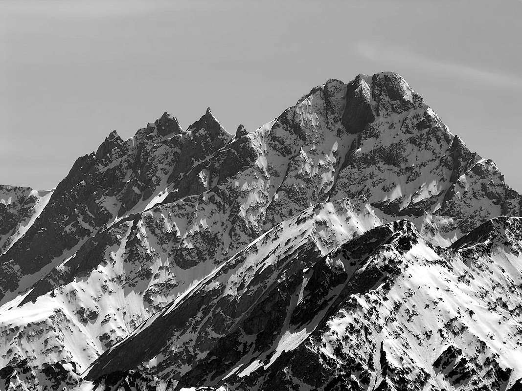
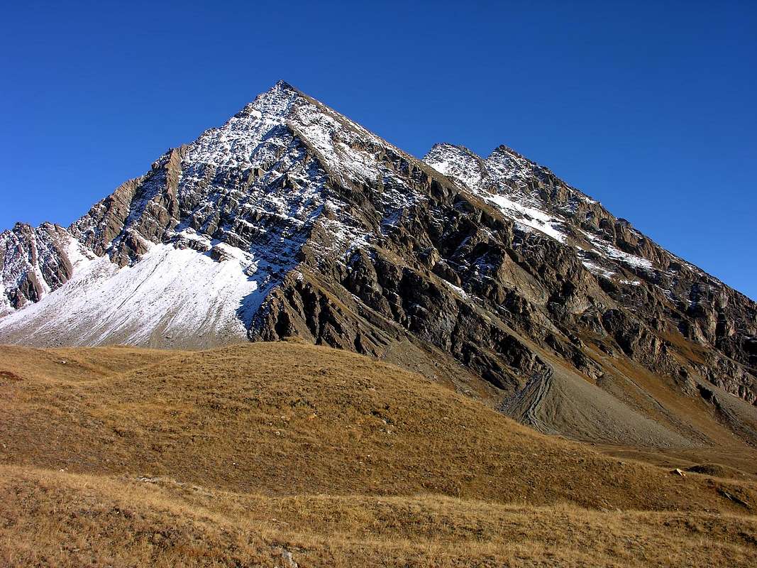
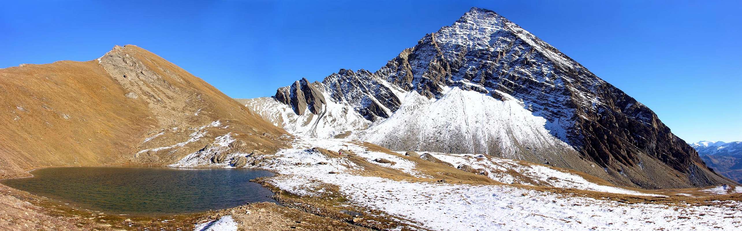
Huge mountain with the shape of a big wonderful quadrangular pyramid, well distinguishable from the High Chavannes Vallon, almost a Valley, but not much appealing for climbers due to its bad rock quality. It is however a wonderful point of sight upon the Mont Blanc Group and almost all Val d'Aosta mountains. In the North it has two triangularly similar walls facing Northeast and Northwest with the rocky bankes facing diagonally downwards, exactly opposite. Both were covered for the first time in descent, that is in July 1902 by Giacomo Dumontel alone for the second and by the three-party roped of 24 September 1995, while on the 3rd of the same month it had been covered in a solitary climb followed by an integral descent through the Northern Edge. Both walls are more dangerous due to falling stones than difficulties (PD+/AD- with short passages of II°/II°+ and III°- with about 400/20 meters in altitude both for the NO, above the Vallon des Chavannes, that for the NE dominating the Vallon des Charmonts with the remains of the Glacier de la Plate) even if they require a certain commitment and of a bit of experience to find the best route Between the two there is a North Crest that goes up from Col du Berrio Blanc (2.819m), located between Berio or Berrio Blanc (always Sasso Bianco or White Stone) and Mont Favre (2.967m); after a double elevation (2.824 and about 2.835/40 meters) it turns into an aerial edge, but with easier climbing than expected with some passages on short yellowish walls of III°- and overall evaluation from PD+ to AD-. On the other hand, the Southern Ridge, formed by characteristic jagged teeth, one of which is more evident and in shape of a "menacing cannon armed and pointed at the sky" (about 3.170/80 metres), still awaits the first integral ascent, even if the final part, that is from the rounded Sella Meridionale or Southern Saddle 3.142 metri just after the Central Peak (around 3.187/92 metres) to the Summit (3.252/54 metres around), is often traveled in the final stretch of the two Normal Routes (from the East and, more rarely, from the West). On the Western Side, between the Via Normale from the Vallon des Chavannes and the Northwest Wall, another route climbs, which marks the beginnings of Classic Mountaineering with an ascent in August 1896 by Giovanni Bobba with the Mountain Guide of Rhêmes Casimiro Thérisod. This climbs parallel to the Via Normale above the Alpe del Berrio Blanc Damon (Highest Pastures, 2.439 meters; see below in section "Route") but, if that is not very popular, this so much less, because is probably still waiting for the first repetition, with probably difficulties of PD. The opposite or Eastern Side also it has variations on the Via Standard from Vallon des Orgères; climbed for the first time by Alphonse Favre with a solitary climb through the easy East Canal, formed by large boulders alternating with detrital outcrops and, at times, with snow (from F to F+ and from F+ to F), to the Sella 3.142 meters with the Central Summit and to the Southern Crest in the final stretch. Here there are two variants:
a) - climb the first part with the previous itinerary (F/F+) and then move further to the left (South) aiming at a rocky channel that "dies" on a notch just a North of Punta Centrale (about 3.180 meters). On fairly difficult rock (AD-/AD) and with passages up to III°/III°+ go up on slabs of rock that are not always safe and with few holds, even overcoming small chimneys with crumbling rocks. This route was built by the Frenchman Alphonse Pelloux with soldier Foy on August 17, 1898.
b) - from via of the gully on the right (North) avoid going around the terminal tower on the left (Southern Crest at final part of Orgères's Standard Route) or on the right using the medium-high part of the Eastern Crest (as performed by the mountaineers Christian Cardellina and Danilo Garzotto on September 24th, 1995), but face it directly on very steep and delicate rocks mixed with unsafe soil (II°+/III°-), as performed by the mountaineer Osvaldo Cardellina with a solitary ascent on the same day. Both the complete Eastern Crest from Col des Orgères (2.620m) to the East-southeast and the Southern Ridge via the very wild Côte de Longeron (2.701, 2.769, 2.768, 2.729 meters) remain to be fully explored or even starting starting even more and further S-SE from Mont Combe Varin (2.708m), just at the entrance on adjacent twin Vallons of Chavannes/Orgères.
Imponente montagna dall'aspetto di una enorme e magnifica piramide quadrangolare; ben distinguibile dall'Alto Vallone di Chavannes, ma di non particolare interesse alpinistico per la sua scarsa qualità della roccia. Rimane comunque, un formidabile punto di osservazione sulla Catena del Monte Bianco e su quasi tutte le montagne della Valle d'Aosta. A Settentrione presenta due pareti triangolarmente similari indirizzate a Nordest e Nordovest con le banconate rocciose rivolte in diagonale verso il basso, esattamente opposte. Entrambe sono state percorse per la prima volta in discesa cioé nel luglio 1902 da Giacomo Dumontel in solitaria per la seconda e dalla cordata a tre del 24 Settembre 1995, mentre il 3 dello stesso mese era stata percorsa in salita solitaria seguita da discesa integrale tramite lo Spigolo Nord. Entrambe le pareti presentano più pericolosità per la caduta di pietre che difficoltà (PD+/AD- con brevi passaggi di II°/II°+ e III°- con circa 400/20 metri di dislivello sia per la NO, al di sopra del Vallon des Chavannes, che per la NE dominante il Vallon des Charmonts con i residui del Glacier de la Plate) anche se richiedono un certo impegno ed un pò di esperienza per reperire la migliore via. Tra le due é collocata una Cresta Nord che risale dal Col du Berrio Blanc (2.819 m), posto tra il Berio o Berrio Blanc (sempre Sasso Bianco) ed il Mont Favre (2.967 m); dopo una duplice elevazione (2.824 e 2.835/40 metri circa) la medesima si trasforma in uno spigolo aereo, ma dall'arrampicata più facile del previsto con alcuni passaggi su brevi muretti giallognoli di III°- e valutazione complessiva da PD+ ad AD-. Per contro la Cresta Sud, formata da caratteristici denti frastagliati dei quali uno in maggior evidenza ed a guisa di "minaccioso cannone armato e puntato contro il cielo" (3.170/80 metri circa), attende ancora la prima salita integrale, anche se la parte finale, ovvero dalla Sella 3.142 metri alla Sommità (3.252/54 m), viene spesso percorsa nel tratto finale delle due Vie Normali (da Est e, più raramente, da Ovest). Sul Versante Occidentale, tra la Via Normale dal Vallon des Chavannes e la Parete Nordovest, sale un'altra via, che contraddistingue gli albori dell'Alpinismo Classico con salita nell'agosto del 1896 da parte di Giovanni Bobba con la Guida di Rhêmes Casimiro Thérisod. Questa sale in parallelo alla Via Normale sopra l'Alpe del Berrio Blanc Damon (2.439 metri; vedi sotto in "Route") ma, se quella é poco frequentata, questa non lo é per nulla tanto, che probabilmente aspetta ancora la prima ripetizione, con presunte difficoltà valutabili in PD. Anche il versante opposto od Orientale presenta delle variante alla Via Standard dal Vallon des Orgères, salito per la prima volta da Alphonse Favre con scalata solitaria tramite il facile Canalone Est, formato da grandi macigni alternati ad affioramenti detritici ed, a volte, con neve (da F a F+ e da F+ a F), alla Sella 3.142 metri e per la Cresta Meridionale nel tratto finale. Da qui esistono due varianti:
a) - salire nella prima parte tramite il precedente itinerario (F/F+) spostandosi gradualmente più a sinistra (Sud) mirando ad un canale roccioso che va a "morire" su d'un intaglio roccioso giusto a Settentrione della Punta Centrale (circa 3.180 metri). Su abbastanza difficili rocce (AD-/AD) e tramite passaggi fino al III°/III°+ arrampicare su placche rocciose non sempre sicure e scarsamente appigliate, vincendo piccoli camini con materiale sospeso. Realizzata dal francese Alphonse Pelloux col soldato Foy il 17 Agosto del 1898.
b) - dalla via del canalone di destra evitare di aggirare il torrione terminale sulla sinistra (Cresta Sud) oppure a destra utilizzando la parte medio-alta della Cresta Est (come effettuato da Christian Cardellina e Danilo Garzotto il 24 Settembre 1995), bensì affrontare direttamente il medesimo su rocce molto ripide nonché delicate frammiste a terriccio (II°+/III°-), come effettuato da Osvaldo Cardellina con salita solitaria nello stesso giorno. Rimangono da esplorare integralmente e completamente sia la Cresta Est dal Col des Orgères che la Sud tramite la selvaggia Côte de Longeron (2.701, 2.769, 2.768, 2.729 metri) od addirittura partendo più a S-SE dal Mont Combe Varin (2.620 m), giusto all'imbocco dei Valloni Chavannes/Orgères.
First Ascents
First on the summit (from S-O Slope): Pietro and Delfino Perrod?.
E Gully: Alphonse Favre, (1865).
E Gully and E Wall (central summit): Alphonse Pelloux and soldier Foy, (Aug 17th, 1898).
W Slope: Giovanni Bobba and Casimiro Thérisod, (Aug 23th, 1896).
E Slope and Eastern Face of Summit Tower (direct to Summit): Osvaldo Cardellina, lone, (Sep 24th, 1995); in ascent
NE Face (from Summit): Christian Cardellina, Osvaldo Cardellina and Danilo Garzotto, (Sep 24th, 1995); in descent.
E Crest (from middle part): Christian Cardellina and Danilo Garzotto, (Sep 24th, 1995); in ascent.
NE Face (to Summit): Osvaldo Cardellina, solo, (Sep 03th, 1995); in ascent.
N-W Wall: Giacomo Dumontel, (Jul 05th, 1902), in descent.
N Arête: One surveyor I.G.M. Land Registry Office (Before 1896), in ascent.
N Edge (integral via to Berio Col): Osvaldo Cardellina, solo, (Sep 03th, 1995); in descent.
Getting There
BY CAR:
From Switzerland: through the Grand Saint Bernard Tunnel or the namesake Pass.
From France: through the Mont Blanc Tunnel or Petit Saint Bernard Pass: It is not necessary to take Motorway A5: you can drive on SS.26, in the direction of Aosta.
From Torino, Milano, etc: Motorway A5. Exit at Morgex (921m), continue for about 3 km on SS.26 towards Pré Saint Didier (1.017m). SS.26 becomes the main street of the small city and then continues toward Colle del Piccolo San Bernardo (2.188m). After several hairpins, and past the Villages of Elevaz (1.302m) and la Balme (1.309m) reach the famous ski resort of La Thuile (1.441m). Turn left on the bridge that crosses "Dora di La Thuile", a go on along the same road till the bridge before the Village of Pont Serrand, turn to the right following for Orgère (1.740m), where you must leave the car.
BY PLANE:
Aeroporto "Corrado Gex" Saint Christophe (Aosta).
Route
On foot along the dirt road in the Chavannes Valley and, after passing Chavannes Pastures (2.128m), toward North up to Berio Blanc di Sopra Pastures (2.439m), just at the base of the SW side of the mountain. Cross in plan toward East to get the wide canyon coming down left of the big spur ending on the Central Summit. On along it on debris and big slabs, often dirty with mould, till a little under the Central Summit. From the high part of the channel cross to the left to get a small channel that goes on to a notch on the Southern Ridge. Follow the ridge on slabs and unstable but safe rocks.
Descent: For the slope East (high gully 750m).
Proseguire a piedi sulla strada in terra battuta il lungo Vallone di Chavannes, dopo aver superato l'Alpeggio di Chavannes di Sotto (2.128 m); continuare verso Nord sino a raggiungere l'Alpeggio di Berio Blanc di Sopra (2.439 m), alla base del versante Sud-Ovest della montagna. Da qui attraversare verso est quasi in terreno pianeggiante e per pascoli raggiungere il largo canalone che scende sulla sinistra del grande costone terminante sulla Punta Centrale. Risalire il canalone di detriti e grandi placche inclinate, sovente coperte da terriccio, sino sotto la Punta Centrale. Dalla cima del canalone traversare in diagonale sulla sinistra sino a un valloncello che continua a salire, sempre sulla sinistra (verso nord), fino a un colletto sulla Cresta Sud della cima. Da questo punto, sempre lungo la cresta Sud, si raggiunge la vetta per lastroni e rocce instabili ma abbastanza sicure.
Discesa: Lungo il versante Est (per il canalone alto 750 m).
Equipment
Normal hiking equipment.
Difficulties
This route can be considered F+/EE.
Campings
Remember that free camping is forbidden (except for emergency reasons, over 2.500m, from darkness until dawn).
Mountain Condition
You can get meteo information at the official site of the Regione Valle d'Aosta:
Parents refers to a larger category under which an object falls. For example, theAconcagua mountain page has the 'Aconcagua Group' and the 'Seven Summits' asparents and is a parent itself to many routes, photos, and Trip Reports.

 14154 Hits
 93.58% Score
 43 Votes