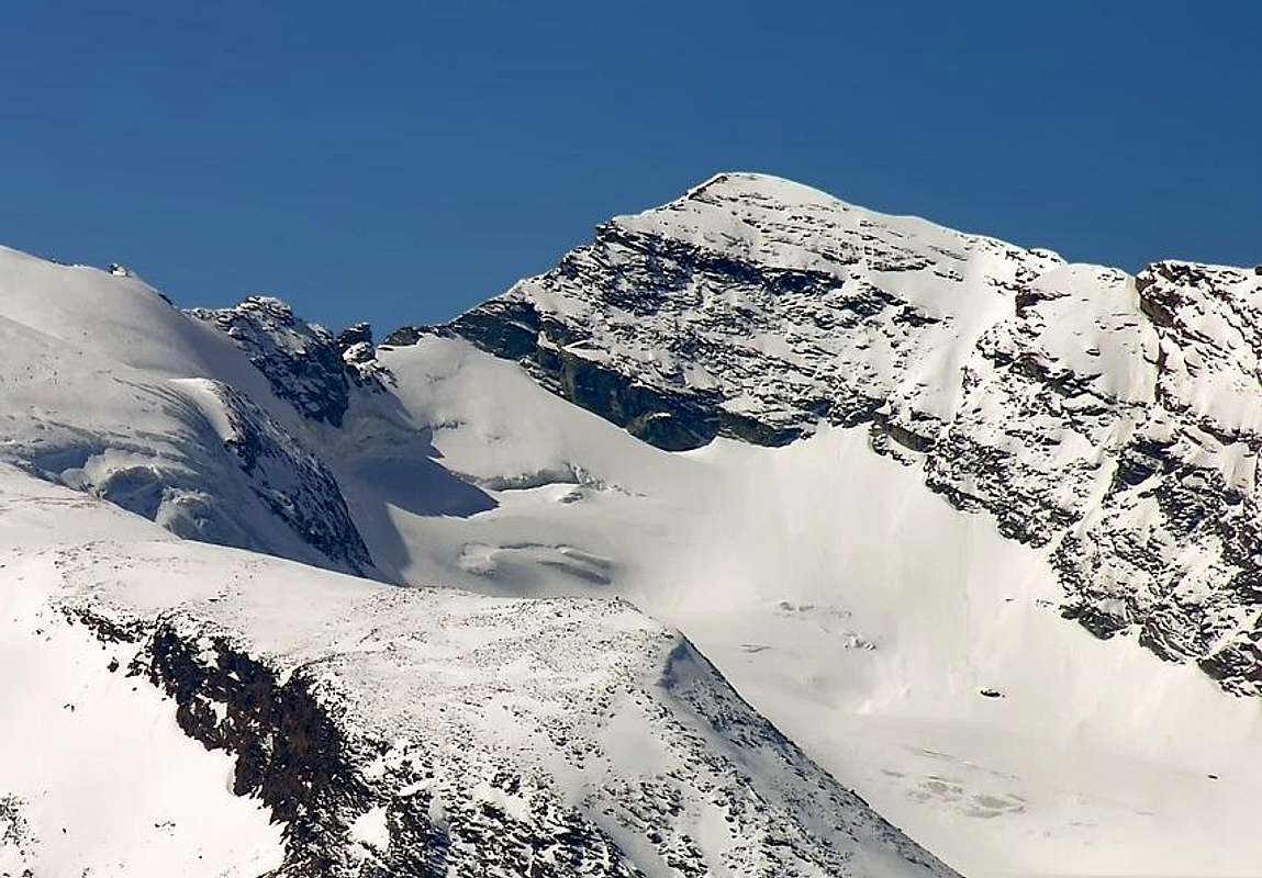
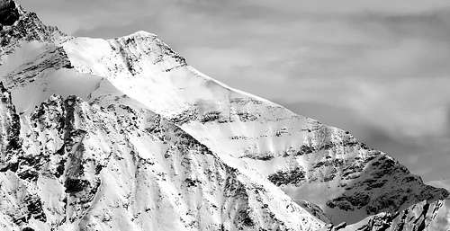
The fine Pyramid of the Grivola dominates, from its almost 4.000m, a small series of less known summits. Among these ones, if seen from Northwest, 3 stand out for their highness: the Punta Rossa (Red Top - 3.630m), the Punta Nera (Black Top - 3.683m) and the Punta Bianca (White Top - 3.793m) that is nothing but the South Shoulder of the Grivola.
La bella piramide dalla Grivola domina dall'alto dei suoi quasi 4.000 metri una serie di altre altre punte meno note. Tra queste se viste da Nordovest tre spiccano per la loro altezza: la Punta Rossa (3.630 m), la Punta Nera (3.683 m) e la Punta Bianca (3.793 m), che altri non è che lo Spallone Meridionale della Grivola.
First Ascents
First on the summit: P. B. Chamonin and A. J. Jantet, (Sep 21th, 1858).
First in winter: E. Giraudo, G. Giraudo and A. Rivera, (Mar 10th, 1940).
E Arête: W. A. B. Coolidge, F. Gardiner, C. J. Almer and R. Almer, (Aug 12th, 1889).
S Wall: G. Bobba and C. Thérisod, (Jul 07th, 1890).
W Arête: C. Bianco and E. Muller, (Aug 1935).
N Arête: P. B. Chamonin and A. J. Jantet, (Sep 21th, 1858), in descent.
N-E Wall: L. Cossard, V. Marcoz and R. Chabod, (Aug 16th, 1936).
Getting There
BY CAR:
From Torino, Milano, etc: Motorway A5. Exit at Aosta Ovest. Drive to the near Aymavilles. Follow the directions for Valle di Cogne.
From Switzerland: through the Grand Saint Bernard Tunnel or the namesake Pass. Drive to Aosta, then follow the direction for Courmayeur on SS.26. Just after Sarre, turn to the left, in the direction of Valle di Cogne.
From France: through Mont Blanc Tunnel or Petit St. Bernard Pass. It isn't necessary to take Motorway A5: you can drive on SS.26, in the direction of Aosta. Before arriving at the Village of Sarre, turn right following the sign for Valle di Cogne. After Aymavilles, the SR.47 crosses the Villages of Vieyes, Epinel and Cretaz and after about 25 Km arrives at Cogne (1.534m). From Cogne you can get the Village of Valnontey (1.666m).
BY PLANE:
Aeroporto "Corrado Gex" Saint Christophe (Aosta).
Route
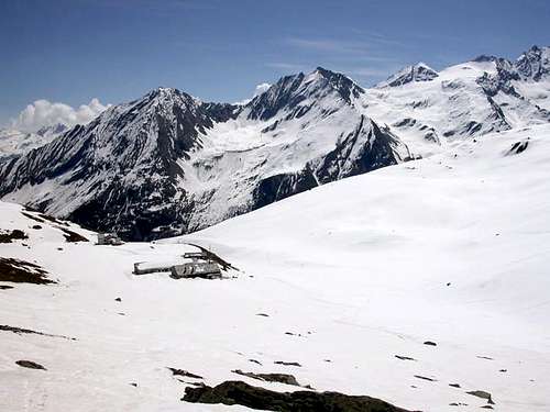
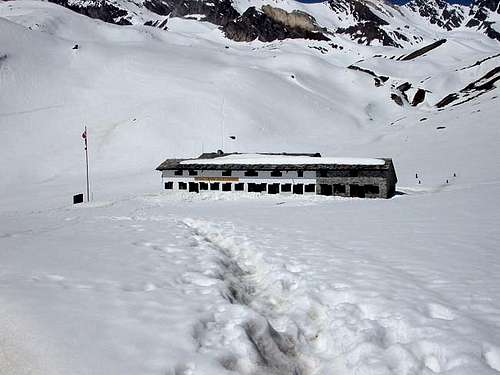
From Valnontey (1.666m), a small Village S of Cogne, along a comfortable muletrack starting from the meadows once crossed the bridge you can get the Rifugio Vittorio Sella (2.584m) placed in a wide plain near the Loson stream. From the Refuge on, along a well marked path, up to the morain of the small Rayes Noires Glacier, near the Colle della Nera (3.491m); here you must ascend, along tracks on debris and snow fields, the channel leading to the West of the lower depression. Following along the easy NE ridge of the Punta Nera (3.683m) in about 40 minutes you can get its Summit. Herefrom, along the West Ridge, down, on easy rocks, to the notch (3.669m).Following the easy ridge, in less than 30 minutes, you arrive to the Punta Bianca Summit (3.793m).
Descend: along the same route.
Da Valnontey (1.666 m), Frazione di Cogne, salire al Rifugio Vittorio Sella (2.584 m), situato in un ampio pianoro, presso il Torrente Gran Loson. Il rifugio si raggiunge seguendo la comoda mulattiera che si stacca dai prati al di là del ponte. Dal rifugio si prosegue su evidente sentiero sino alle morene del piccolo Ghiacciaio della Rossa (o Rayes Noires), nei pressi del Colle della Nera (3.491 m); si risale su tracce detritiche di sentiero e nevai il canalone che sbuca a Ovest della massima depressione. Continuare per la facile e detritica cresta Nord-Est e in circa 40 minuti si giunge sulla Vetta della Punta Nera (3.683 m), dalla quale in breve per la Cresta Ovest si scende sino all'intaglio (3.669 m) su blocchi e rocce rotte. Seguire comodamente la cresta che, con le stesse caratteristiche, in circa 30 minuti si conclude sulla Punta Bianca (3.793 m), semplice spallone della Cresta Sud della Grivola.
Within the borders of the P.N.G.P. (Parco Nazionale del Gran Paradiso), at the moment (summer 2004), dogs generally are not allowed, except on a couple of trails, and camping is forbidden (except for climbers from sunset till dawn). No fees are due.
Books and Maps
BOOKS:
"Guida dei Monti d'Italia-Gran Paradiso Parco Nazionale" E. Andreis, R. Chabod, M. C. Santis, Club Alpino Italiano/Touring Club Italiano, prima Ed. 1939; seconda Ed. 1963; terza Ed. 1980.
"I Rifugi della Valle d'Aosta" di Stefano Ardito, Ed. Guide iter, Febbraio 2003.
"Parco Nazionale del Gran Paradiso" di Stefano Ardito, Ed. Guide iter, Novembre 2001.
"Guida delle Alpi Occidentali", di Giovanni Bobba e Luigi Vaccarone C.A.I. Sezione di Torino Volume II (parte II), 25 Maggio 1896.
"80 itinerari di Escursionismo Alpinismo e Sci Alpinismo in Valle d'Aosta", di Osvaldo Cardellina, Ed. Musumeci, Giugno 1977 (in Italian); seconda Ed. Luglio 1981; terza Ed. Luglio 1984; (in French), prima Ed. Febbraio 1978; seconda Ed. Marzo 1980.
"Diari Alpinistici" di Osvaldo Cardellina e Indice Generale accompagnato da Schedario Relazioni Ascensioni 1964-2019 (inediti).
"Rifugi e bivacchi in Valle d'Aosta", di Cosimo Zappelli aggiornata da Pietro Giglio, Musumeci Editore, Luglio 2002.
"Guida della Regione Autonoma Valle d'Aosta" di Mario Aldrovandi, Ed. S.P.E. di Carlo Fanton, Torino 31 Dicembre 1964.
"Pelli di Foca in Valle d'Aosta", di Franco Lenzi Editoriale Pedrini, Torino 1988.
"Gran Paradiso itinerari escursionistici" di Franco Brevini, Ed. Musumeci, Luglio 1982.
MAPS:
Kompass "Gran Paradiso Valle d'Aosta Sentieri e Rifugi" Carta Turistica 1:50.000.
Enrico Editore Ivrea-Aosta "Gruppo del Gran Paradiso" 1:50.000.
L'Escursionista "Valle di Cogne Carta dei Sentieri" 1:25.000.
L'Escursionista "Tour de la Vallée de Cogne Grand Paradis" 1:25.000.
I.G.C. Istituto Geografico Centrale "Parco Nazionale del Gran Paradiso" 1:50.000.
A.I.NE.VA. (Associazione Interregionale Neve e Valanghe).
A.IA.T. Cogne Gran Paradis via Bourgeois n° 34 Tel. 0165-74040. E-mail: aiat@cogne.org
Ezio Sport articoli sportivi - via Bourgeois n° 64 Tel. 0165-74204.
Useful numbers
Soccorso Alpino Cogne (SAR) Tel. 3482685406.
Protezione Civile Valdostana località Aeroporto n° 7/A Saint Christophe (Ao) Tel. 0165-238222.
Bollettino Meteo (weather info) Tel. 0165-44113.
Bollettino Valanghe Tel. 0165-776300.
Unità Operativa di Soccorso Sanitario Tel. 118.
Acknowledgements
I am greatly indebted to my friend "Osva" for all texts and the detailed description of the route. In addition I want to thank Gabriele Roth for the translation of the text from italian.
Children refers to the set of objects that logically fall under a given object. For example, the
Aconcagua mountain page is a child of the 'Aconcagua Group' and the 'Seven Summits.' The
Aconcagua mountain itself has many routes, photos, and trip reports as children.
Parents refers to a larger category under which an object falls. For example, theAconcagua mountain page has the 'Aconcagua Group' and the 'Seven Summits' asparents and is a parent itself to many routes, photos, and Trip Reports.

 12687 Hits
 91.45% Score
 35 Votes