
-
 8963 Hits
-
 88.19% Score
-
 26 Votes
|
|
Mountain/Rock |
|---|---|
|
|
45.53275°N / 7.39599°E |
|
|
Mountaineering |
|
|
11181 ft / 3408 m |
|
|
Overview
Imposing and appealing mountain, it is the second summit of the ridge that, starting from the Punta di Loye (2.676m) to the North goes toward South to the Punta di Ondezana (3.492m). Amazing for the view of the series of seracs of the homonymous glacier, in full view from Lillaz.
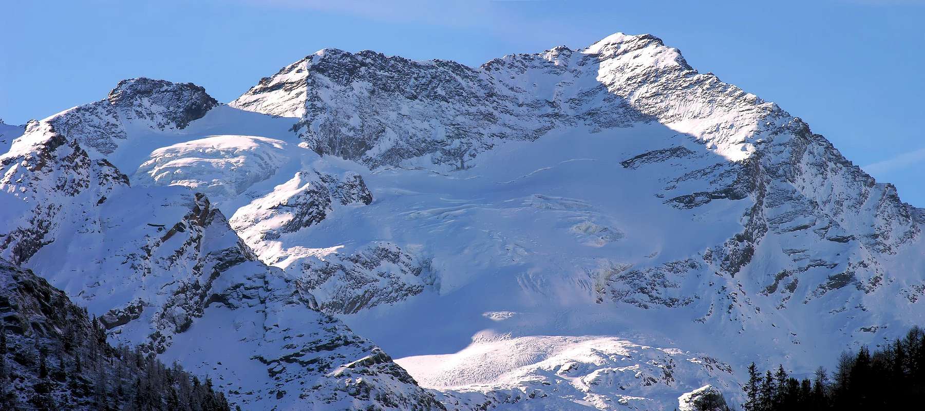
Maestosa e attraente montagna; è la seconda vetta della cresta che, dalla Punta di Loye (2.676 m) a nord, va alla Punta di Ondezana (3.492 m) a sud. Piacevole alla vista per la seraccata dell'omonimo ghiacciaio ben visibile dalla Frazione di Lillaz.
MAPS:
First Ascents
- First on the summit S Arête: D. W. Freshfield, C. C. Tucker, D. Minnigerode, F. Devouassoud and P. L. Guichardaz, (Sep 04th, 1876).
- In winter: Giusto Gervasutti, E. and P. Giraudo, (Date ?).
- S-W Wall: L. and M. Borelli, (Sep 09th, 1906), in descent.
- N-W Arête: E. Andreis and L. Bon, (Jul 29th, 1937), in descent.
- N Wall: Luigi Carrel and Giovanni Passerin d'Entreves, (1924).
- N Slope and E-NE Arête: G. Tonella and G. Codrig, (Aug 09th, 1925).
- S-SE Wall: G. Calosci and G. Ourlaz, (Jul 23th, 1938), in descent.
Getting There
BY CAR:- From Torino, Milano, etc: Motorway A5. Exit at Aosta Ovest. Drive to the near Aymavilles. Follow the directions for Valle di Cogne.
- From Switzerland: through the Grand Saint Bernard Tunnel or the namesake Pass. Drive to Aosta, then follow the direction for Courmayeur on SS.26. Just after Sarre, turn to the left, in the direction of Valle di Cogne.
- From France: through Mont Blanc Tunnel or Petit St. Bernard Pass. It isn't necessary to take Motorway A5: you can drive on SS.26, in the direction of Aosta. Before arriving at the Village of Sarre, turn right following the sign for Valle di Cogne. After Aymavilles, the SR.47 crosses the Villages of Vieyes, Epinel and Crétaz and after about 25 Km arrives at Cogne (1.534m). From Cogne you can get the Village of Lillaz (1.617m).
BY PLANE:
- Aeroporto "Corrado Gex" Saint Christophe (Aosta).
Route
First day: From Cogne (1.534m) using bus or car to Lillaz (1.617m): car parking in the middle of the built up area. Start along the path toward Valeille Valley, after a terrace follow to a bridge near a big boulder. Cross the bridge and follow along the mule track on the left side (hydrographic) of Valeille, a big landslide must be passed along tracks. Now along the track leading to the ridge of the morain on the left side (hydrographic) of Valeille Glacier, follow the ridge till its end (once there was the old bivouac, destroyed by an avalanche) and, on quite difficult slopes to the Malvezzi-Antoldi Bivouac (2.920m): 4h'15/5h'00 hours from Lillaz.1° Giorno: Dall'abitato di Cogne (1.534 m) in bus o in auto raggiungere la ridente Frazione di Lillaz (1.617 m), dove si parcheggia l'auto nel grande piazzale sito quasi al centro del villaggio. Iniziare la salita imboccando il sentiero che si dirige nel Vallone di Valeille; dopo aver superato un gradone si prosegue sino a un ponte sito a breve distanza di un grande macigno. Dopo averlo attraversato, continuare lungo la mulattiera sulla sinistra orografica della Valeille superando su tracce di sentiero una enorme frana. Lasciare il ramo (rivolto alle pendici delle Punte Patrì) seguendo la traccia di sentiero che sale in cresta alla morena sulla sinistra orografica del Ghiacciaio di Valeille; percorrere sino al culmine la cresta (dove sorgeva il vecchio bivacco distrutto da una valanga). Da questo punto superato un tratto su terreno abbastanza malagevole, si raggiunge il Bivacco Malvezzi-Antoldi (2.920 m). 4h'15/5h'00 ore circa da Lillaz.
Second day: From the bivouac down to the flat Valeille Glacier, cross toward east (crevasses) pointing to the first channel between the Punta and the Ago delle Sengie. Climb it on the left side (40°-45° danger for falling stones) up to the Colle delle Sengie (3.338m), on along the big slanted slabs of the Southern ridge getting the Summit in half an hour. 3h'30/4h'00 from bivouac.
2° Giorno: Dal bivacco scendere sul pianeggiante Ghiacciaio di Valeille e attraversarlo verso est facendo attenzione ai crepacci; puntare al primo canalone tra la Punta e l'Ago delle Sengie. Salirlo sulla sinistra (40°-45° esposto alla caduta pietre), sino a raggiungere il Colle delle Sengie (3.338 m); risalire le grosse placche inclinate della cresta Sud della Punta delle Sengie raggiungendo la vetta in circa 0h'30. Circa 3h'30/4h'00 dal bivacco. Same route for coming back Discesa lungo l'itinerario di salita.
Difficulties
This route can be considered PD.Gear
Classic for high mountain routes: rope, helmet, iceaxe, crampons.Da alta montagna, corda, casco, piccozza, ramponi.
 |
 |
 |
Huts
Bivacco Laura Malvezzi-Guido Antoldi (2.920 m), 9 posti.Red Tape
Within the borders of the P.N.G.P. (Parco Nazionale del Gran Paradiso), at the moment (summer 2004), dogs generally are not allowed, except on a couple of trails, and camping is forbidden (except for climbers from sunset till dawn). No fees are due.Campings
- Wild camping in the Parco Nazionale del Gran Paradiso is strictly forbidden!!!
Mountain Condition
- You can get meteo information at the official site of the Regione Valle d'Aosta:
- Valle d'Aosta Meteo
Webcam
- WEBCAM on Aosta Valley:
- Webcam
Books and Maps
BOOKS:- "Guida delle Alpi Occidentali" di Giovanni Bobba e Luigi Vaccarone C.A.I. Sezione di Torino Volume II (parte II), 25 Maggio 1896.
- "Rifugi e bivacchi in Valle d'Aosta" di Cosimo Zappelli aggiornata da Pietro Giglio. Musumeci Editore, Luglio 2002.
- "Il Parco Nazionale del Gran Paradiso (Valli di Champorcher-Clavalitè-Saint Marcel-Laures-Cogne-Valsavarenche-Conca di Pila" di Giulio Berruto 3/volume 2°, IGC, Torino 1981, 2a Ed. 2000. (in Italian)
- "Guida dei Monti d'Italia-Gran Paradiso Parco Nazionale" E. Andreis, R. Chabod, M. C. Santis, Club Alpino Italiano/Touring Club Italiano, prima Ed. 1939; seconda Ed. 1963; terza Ed. 1980.
- "Gran Paradiso", A. Gegenfurtner, G. Klotz, F. Müller, Ed. Bergverlag Rudolf Rother, Monaco 1980 (in tedesco).
- "Gran Paradiso", G. Klotz, Ed. Bergverlag GmbH Rother, Monaco 2005 (in tedesco).
- "Gran Paradiso", di Pierandrea Mantovani e Renato Misischi, Ed. Rassegna Alpina, 1974.
 |
 |
 |
 |
 |
- Kompass "Gran Paradiso Valle d'Aosta Sentieri e rifugi" Carta turistica 1:50.000.
- L'Escursionista "Tour de la Vallée de Cogne Grand Paradis" Carta dei sentieri 1:25.000.
- I.G.C. Istituto Geografico Centrale "Gran Paradiso-La Grivola-Cogne" Carta turistica 1:25.000.
- I.G.M. Istituto Geografico Militare Foglio 41 1:25000: I SO Gran Paradiso - I NE Cogne.
- A.IA.T "Cogne Gran Paradiso Cogne Aymavilles-Walking map" 1:25.000.
- L'Escursionista "Valle di Cogne" Carta dei sentieri (n° 10) 1:25.000.
Important Information
- REGIONE AUTONOMA VALLE D'AOSTA the official site.
- FONDAZIONE MONTAGNA SICURA Villa Cameron, località Villard de la Palud n° 1 Courmayeur (AO) Tel: 39 0165 897602 - Fax: 39 0165 897647.
- SOCIETA' GUIDE ALPINE DI COGNE Tel. 347/9473526 – 328/1373728.
- A.I.NE.VA. (Associazione Interregionale Neve e Valanghe).
- A.IA.T. Cogne Gran Paradis via Bourgeois n° 34 Tel. 0165-74040. E-mail: aiat@cogne.org
- Ezio Sport articoli sportivi - via Bourgeois n° 64 Tel. 0165-74204.
Useful Numbers
- Soccorso Alpino Cogne (SAR) Tel. 3482685406.
- Protezione Civile Valdostana località Aeroporto n° 7/A Saint Christophe (Ao) Tel. 0165-238222.
- Bollettino Meteo (weather info) Tel. 0165-44113.
- Unità Operativa di Soccorso Sanitario Tel. 118.