
-
 9333 Hits
-
 91.9% Score
-
 37 Votes
|
|
Mountain/Rock |
|---|---|
|
|
45.64519°N / 7.43483°E |
|
|
Mountaineering |
|
|
Summer, Fall |
|
|
10177 ft / 3102 m |
|
|
Overview
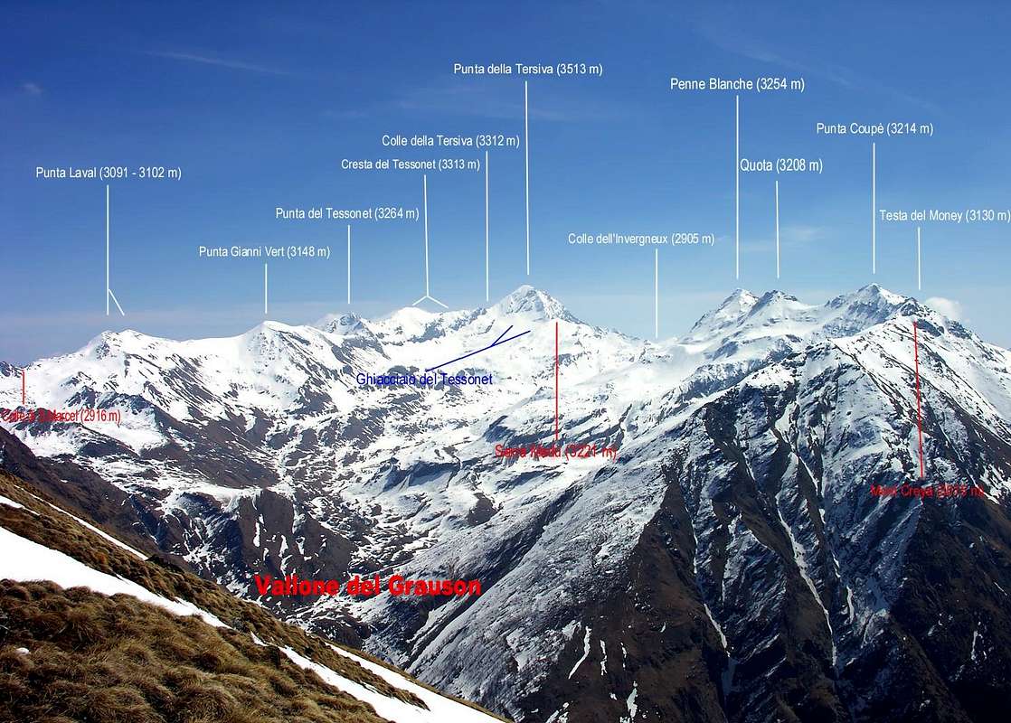
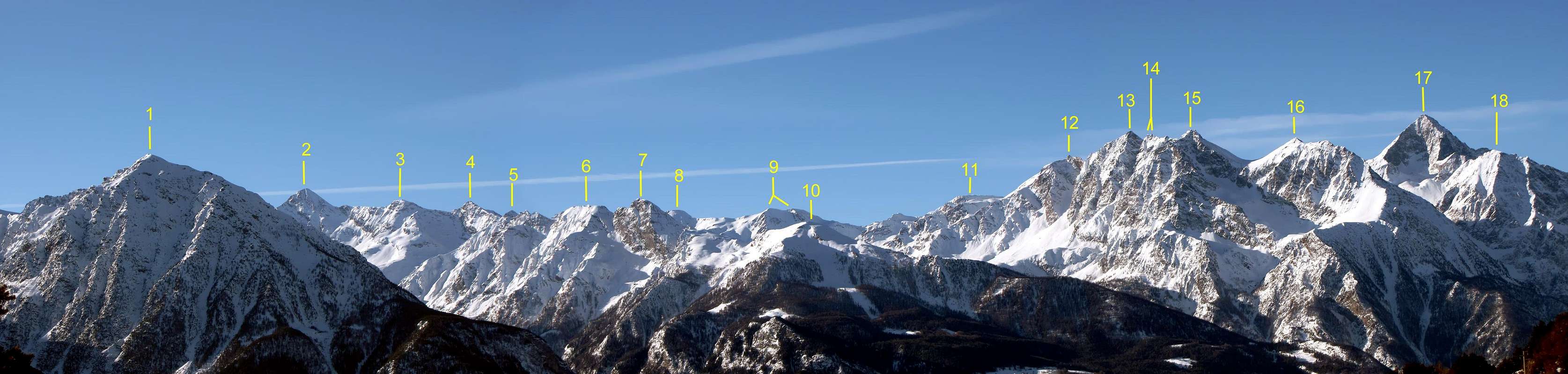
Punta Laval is placed Southeast of Col St. Marcel (2.905m), a pass connecting Vallone del Grauson and Vallone di St. Marcel (which final part is somewhere named Vallone di Fenêtre). It consists of two separated summits, visible from both Vallone di Grauson and Walloon of Saint Marcel. Point 3.091m is surmounted from a small cairn, whereas quota 3.102m doesn't have any signal. The two summits are separated from a nearly flat ridge. The majestic panorama from the peak takes many summits of the Valle d'Aosta in at a glance, in addition to the nearby Punta Tersiva and the complete Emilius Group. The list includes Matterhorn, Grand Combin, and both Gran Paradiso and Monte Rosa Groups. Mont Blanc Group is hidden and only a small portion of Grandes Jorasses is visible through the far narrow window of Passo dei Tre Cappuccini.
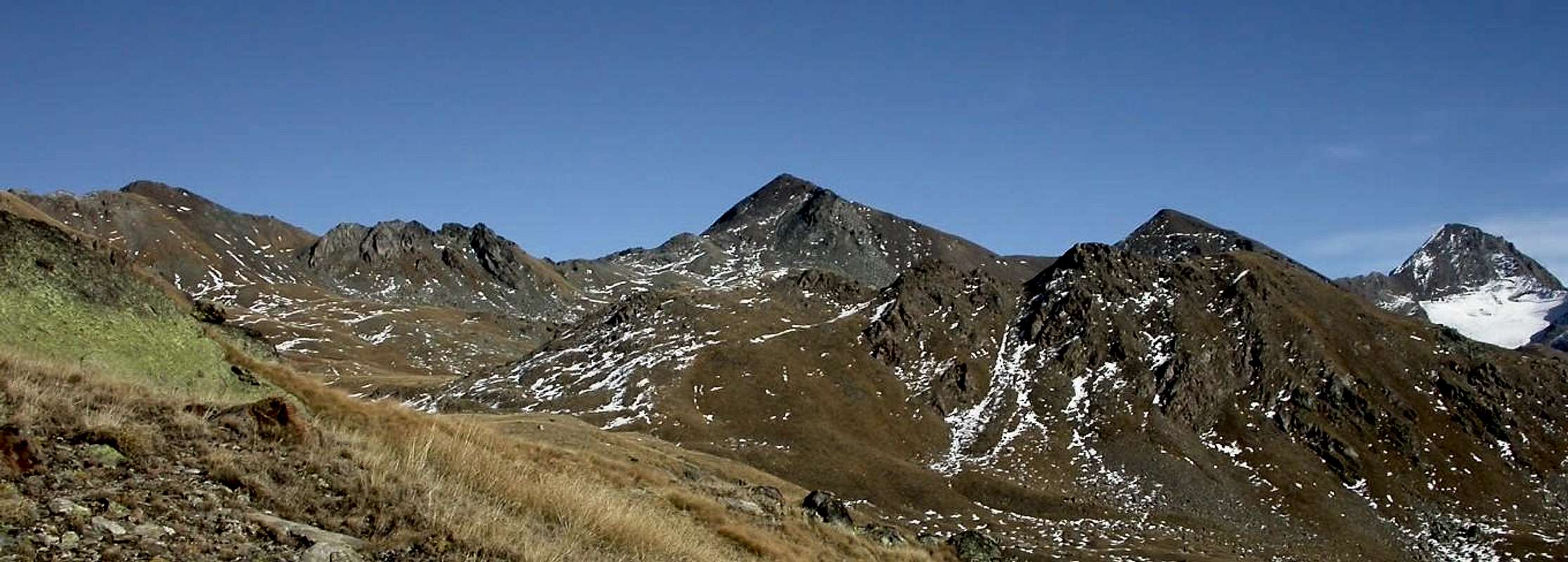
La Punta di Laval è posta a Sudest del Colle di Saint Marcel (2.905 m), formante il passaggio di collegamento tra il Vallone del Grauson e quello di St. Marcel (nella parte finale è conosciuto col nome di Vallon de Fenêtre). Si compone di due cime separate, visibili da entrambi i suddetti valloni. La Sommità 3.091 m è sormontata da un ometto, mentre la successiva Quota 3.102 m non ne possiede alcuno. Le cime son separate da una cresta quasi rettilinea. Il maestoso panorama dalla vetta comprende molte Vette della Valle d'Aosta a colpo d'occhio, oltre la vicina Punta Tersiva e l'intero Gruppo dell'Emilius. L'elenco comprende dal Cervino, al Grand Combin per andare ad entrambi i Gruppi del Gran Paradiso e del Monte Rosa. Il Gruppo del Monte Bianco è nascosto e solo una piccola parte delle Grandes Jorasses è visibile attraverso la stretta finestra costituita dal Passo dei Tre Cappuccini.
![]()
BY PLANE:
First Ascent
- First on the summit: Unknown.
- In winter: Unknown.
Getting There
BY CAR:- From Torino, Milano, etc: Motorway A5. Exit in Aosta Ovest. Drive to the near Aymavilles. Follow in the direction of Valle di Cogne.
- From Switzerland: through the Grand St. Bernard Tunnel or the homonym Pass). Drive to Aosta, then follow Courmayeur direction on SS.26. Just after Sarre, turn to the left, in the direction of Valle di Cogne.
- From France: through Mont Blanc Tunnel or Petit St. Bernard Pass). It isn't necessary to enter in Motorway A5, you can drive through SS.26 Aosta direction. Before arriving at the Village of Sarre, follow the sign and turn right towards Valle di Cogne.After Aymavilles, the SR.47 crosses the Villages of Vieyes, Epinel and Cretaz and after about 25 Km. arrives at Cogne (1.534m). Follow the road signs for Gimillan and Lillaz; arrived at a round-about, recently built in proximity of the St. Anthony Chapel, go left along the scenic route leading to the Village of Gimillan (1.787m), 3 Km. after Cogne. Usually no parking problem.
- Aeroporto "Corrado Gex" Saint Christophe (Aosta).
Approach & Route
Punta Laval shares its route with the nearby Punta Gianni Vert. Difference in height: about 1.304m Ascent time: 4-5 hours. Descent: along the ascent route. Go right starting from the car park of Gimillan (1.787m): after few meters the indications for Lussert Lakes, St. Marcel Pass, etc. are found. The pathway is indicated by the yellow circle and by yellow strips marked on stones along the route. The path begins going immediately uphill, then the slope decreases as we go beyond a little chapel dedicated to the Virgin (1.836m). Soon the path resumes to go up and splits in two, before it begins to penetrate into the Grauson Valley: it's possible to continue following the right one that goes down as far as the Ecloseur Bridge (1.904m), but in such a case we must go up again; it's better to follow the left one that, in practice without losing height, arrives at the bridge under the Alpeggio Pila (2.025m), cross it and, following the stepped pathway, overcome the rocky bastion beside a fine waterfall (at the left). At this point the path turns right markedly, entering, high on the torrent, into a small valley; by an alternation of steep and slight slopes, it reaches a panoramic cross, on the edge of a pleasant plateau (superb view of the far La Grivola!). The path goes through the meadows, slightly descendind: after the Alpi di Grauson Vecchie (2.271m), cross the torrent on the Pikaciù Bridge and by a steep trail beside the stream, reach the wide upper part of the Grauson Valley, where the same splits with the branch-Grauson Lussert North towards homonim lochs and the Tessonet-Doreire to the East, below the Punta Tersiva and at the end of the divide between the Valleys addressed in Cogne and that of Saint Marcel. At the junction before Alpeggio Pralognan (about 2.400m), instead of going straight ahead along the pathway n° 8/TVC leading to the head of Vallone di Grauson, go left till to Alpeggio Grauson Nuove (2.540m), through the ramification to Lussert with path n° 8A, where once there was the burned Tentori Bivouac. Just on the right of the building, go along the pathway, indicated by the yellow circle and by yellow strips marked on stones along the route but with the derivation of the path n° 8B/102, in the direction of the Coronas (or Corona) Lake: cross a brook and by broad hairpin bends, after a small lake on the left, reach the Coronas Lake (2.702m). Cross the effluent of the lake and continue on the right as far as the Saint Marcel Hill or Corona (2.916m), about 1h'45 hours starting from the junction with the pathway n° 8A. After the pass, the pathway becomes intuitive, keep always right and begin to ascend the Punta Laval along the NW side, paying attention since the route goes on along wrecks and broken rocks. After about 40' the double summit of Punta Laval is reached (3.091m / 3.102m), just in front of Punta Gianni Vert (3.148m). Pay attention in the case of snow, in particular during the crossing between the two summits of Punta Laval: stay always under the ridge, avoiding to walk on the snowy cornices, lethal in the event of collapse.
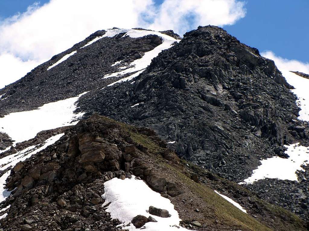
Punta Laval condivide il suo percorso con la vicina Punta Gianni Vert. Dislivello: 1.304 metri Tempo di salita: 4-5 ore. Discesa: lungo l'itinerario di salita. Partendo dal parcheggio di Gimillan (1.787 m) indirizzarsi a destra: dopo pochi metri s'incontrano le indicazioni per i Laghi di Lussert, il Colle di St. Marcel, etc.. Il percorso è indicato da un cerchio giallo e da strisce dello stesso colore marcate sulle pietre lungo il medesimo. S'inizia andando subito in salita, poi la pendenza diminuisce man mano che si oltrepassa una cappellina dedicata alla Vergine (1.836 m). Ben presto il sentiero riprende a salire sdoppiandosi in due vie possibili, prima di cominciare a penetrare nel Vallone del Grauson: è possibile continuare a seguire quella abituale che discende fino al Ponte dell'Ecloseur (1.904 m), ma in tal caso bisogna successivamente risalire; è meglio seguire il ramo di sinistra che, in pratica, senza perdere d'altezza, arriva al ponte sotto l'Alpeggio Pila (2.025 m). Si attraversa lo stesso e, seguendo un camminatoio a gradini, si supera il bastione roccioso subito accanto ad una bella cascata sulla sinistra. A questo punto il sentiero svolta a destra marcatamente, entrando, alto sul torrente, in un valloncello; con un'alternanza di pendii ripidi e più lievi, raggiunge una croce panoramica, ai margini di un piacevole altopiano (superba vista della lontana La Grivola!). Il sentiero attraversa i prati tramite una breve discesa: dopo le Alpi di Grauson Vecchie (2.271 m), attraversare il torrente sul Ponte Pikaciù e per mezzo d'un ripido sentiero accanto al torrente, raggiungere l'ampia parte superiore del Vallone del Grauson, ove il medesimo va sdoppiandosi con un ramo a Settentrione verso il Grauson-Lussert con gli omonimi laghi ed un altro ad Est in direzione di quello del Tessonet-Doreire, al di sotto della Punta Tersiva ed al termine dello spartiacque tra i Valloni rivolti a Cogne a Mezzogiorno ed a quello di Saint Marcel sul versante opposto. Al bivio prima dell'Alpeggio di Pralognan (circa 2.400 metri), invece di proseguire lungo il sentiero n° 8/TVC conducente alla testata del Vallone di Grauson, proseguire sulla sinistra fino all'Alpeggio Grauson Nuove (2.540 m) tramite la diramazione per il Lussert n° 8A, dove una volta c'era il Bivacco Tentori, andato a fuoco. Proprio sulla destra dell'edificio, proseguire lungo il percorso, indicato sempre dal cerchio giallo e da strisce gialle marcate sulle pietre lungo il percorso ma con la derivazione di sentiero n° 8B/102, in direzione del Lago Coronas (o Corona). Attraversato un torrentello e tramite ampi tornanti, dopo un laghetto sulla sinistra, raggiungere il Lago Coronas (2.702 m). Attraversarne l'emissario proseguendo sulla destra fino al Colle di Saint Marcel o Corona (2.916 m) in circa 1h'45 ore a partire dal bivio con il sentiero n° 8A. Dopo il passo, il sentiero diventa "intuitivo" e tenendo sempre la destra incominciare a salire la Punta di Laval lungo il suo lato Nordovest, facendo una qual attenzione in quanto il percorso prosegue lungo detriti e rocce rotte. Dopo circa 40' si raggiunge la doppia vetta della Punta di Laval (3.091 m, 3.102 m), proprio di fronte alla Punta Gianni Vert (3.148 m). Prestare attenzione in caso di neve, in particolare durante la traversata tra le due cime della Laval: conviene restare sempre al di sotto della cresta, evitando di camminare sui cornicioni di neve, letali in caso di crollo.
Normale equipaggiamento da montagna.
![]()
Red tape
No restriction at all: Punta Laval is very near but outside the borders of the Gran Paradiso National Park and Monte Avic Natural Park.
Bus lines
SAVDA bus lines connect Aosta to Cogne. In addition, both in summer and in winter, S.A.V.D.A. shuttle bus connect Cogne with the villages (Gimillan and Lillaz, in our case).Campings
Remember that free camping is forbidden (except for emergency reasons, over 2500m, from darkness until dawn).
Meteo
- Meteo: you can find all the needed informations at the official site of the Valle d'Aosta Region:
- Valle d'Aosta Meteo
Webcam
- WEBCAM on Aosta Valley:
- Webcam
Books and Maps
BOOKS:
- "Guida delle Alpi Occidentali" di Giovanni Bobba e Luigi Vaccarone C.A.I. Sezione di Torino Volume II (parte II), 25 Maggio 1896.
- "Guida dei Monti d'Italia–Emilius Rosa dei Banchi Parco del Mont Avic" di Giulio Berutto e Lino Fornelli-Club Alpino Italiano/Touring Club Italiano, Marzo 2005 (in Italian).
 |
 |
MAPS:
- Kompass "Gran Paradiso Valle d'Aosta Sentieri e rifugi" Carta turistica 1:50.000.
- Enrico Editore Ivrea-Aosta "Gruppo del Gran Paradiso" 1:50.000.
- L'Escursionista "Valle di Cogne Carta dei Sentieri" (n° 10) 1:25.000.
- L'Escursionista "Tour de la Vallée de Cogne Grand Paradis" Carta dei sentieri 1:25.000.
Important Information
- REGIONE AUTONOMA VALLE D'AOSTA the official site.
- FONDAZIONE MONTAGNA SICURA Villa Cameron, località Villard de la Palud n° 1 Courmayeur (AO) Tel: 39 0165 897602 - Fax: 39 0165 897647.
- SOCIETA' GUIDE ALPINE DI COGNE Tel. 347/9473526 – 328/1373728.
- A.I.NE.VA. (Associazione Interregionale Neve e Valanghe).
- A.IA.T. Cogne Gran Paradis via Bourgeois n° 34 Tel. 0165-74040. E-mail: aiat@cogne.org
- Ezio Sport articoli sportivi - via Bourgeois n° 64 Tel. 0165-74204.
Useful numbers
- Soccorso Alpino Cogne (SAR) Tel. 3482685406.
- Protezione Civile Valdostana località Aeroporto n° 7/A Saint Christophe (Ao) Tel. 0165-238222.
- Bollettino Meteo (weather info) Tel. 0165-44113.
- Unità Operativa di Soccorso Sanitario Tel. 118.