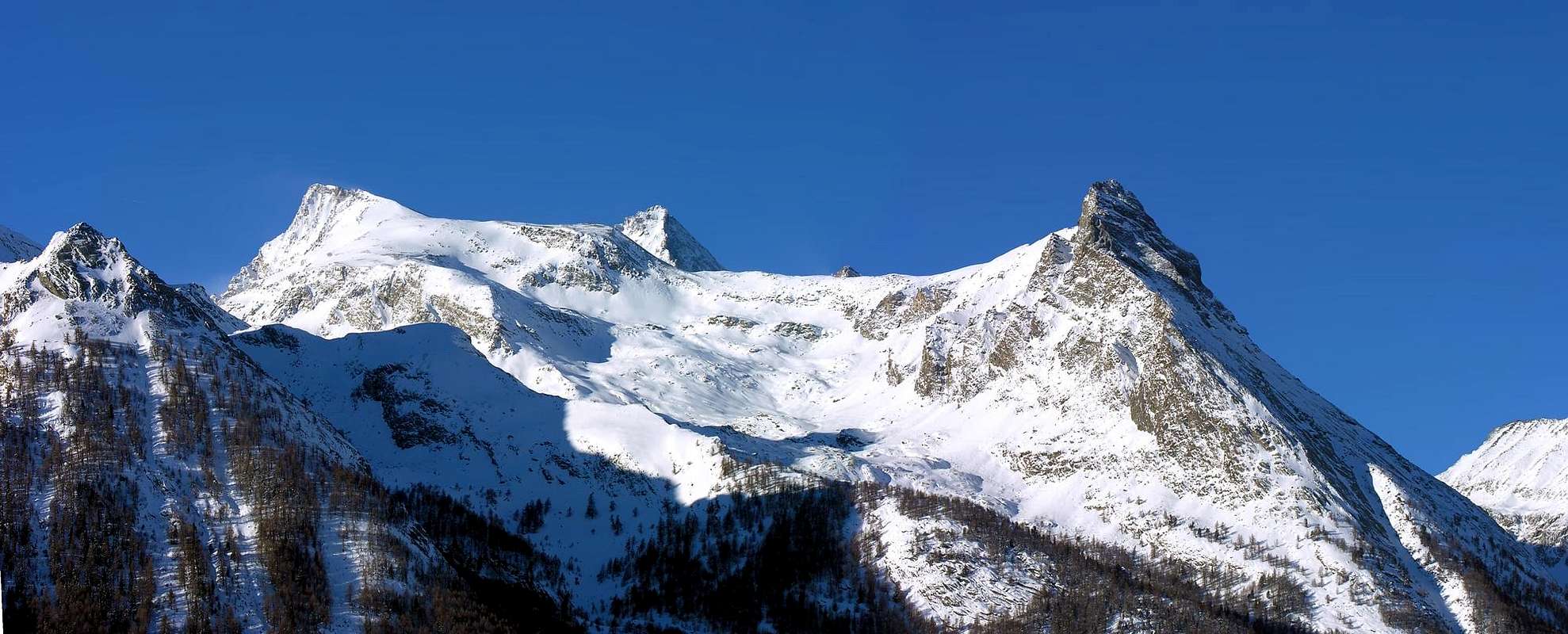
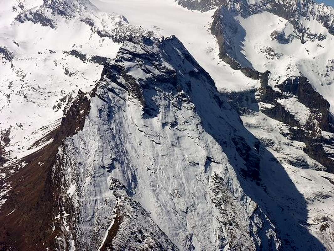
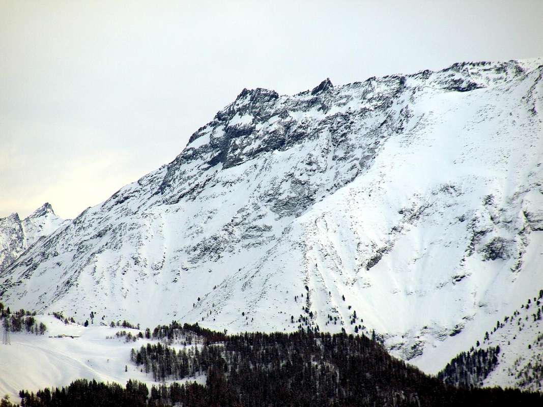
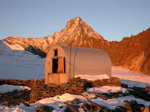
This is the last rocky Summit, shaped a triagle pyramid, of the Northeast Ridge of Punta Rossa (3.630m). Fine point of observation on Cogne and its well known St. Orso Plain, from its Top an exceptional panoramic view of the close Grivola and Gran Paradiso Massif, and the whole ranges of Mont Blanc Group and Pennine Alps. Its name derives from from "pouce", that is to say like a thumb, and from the diminutive-pet name "poucet" that is a small rocky thumb, impertinently turned to the sky. A toponym that we also find on the N-NE "Crestone" of Becca di Nona, opposite but on the other side of the Grand Eyvia and in the Monte Emilius Group, capable of characterizing and identifying the last roughness before the Top. Here instead, the graceful name indicates the whole mountain. This is located between the Pousset Vallon to the Northeast and East and the small Comba or Basin de Ronc - Vallet, secondary and more little valley of the much more important Vallone del Trajo or Tradzo, immediately to the Northwest as well as above the Alpe del Trayo with the nearby Casotto del PNGP (+; 2.035 and 2.155 meters), at the end of the watershed that descends towards North from Punta Nera and then from Punta Rossa della Grivola (3.683 meters and 3.625/30 meters approximately). Between the latter and Punta del Pousset, right on the ridge and at an altitude of 3.198 meters at Colle del Pousset, is the Luciano Gratton Bivouac, open since 1984 and dedicated to a mountaineer from Cogne who died in 1973.This rocky pyramid, which looms over the inhabited areas of the Hamlets of Crétaz and Epinel, is also clearly visible from the Municipality of Cogne, of which, indeed, it represents its emblem, it is quite popular from its Eastern Side with the final SW ridge. Much more famous in the past two centuries thanks to its splendid panorama, as mentioned above, on the surrounding alpine circle and in the distance towards the Graian Alps, the Mont Blanc Chain as well as the Pennine Alps up to Monte Rosa. The same was in great and open competition with that offered by the view from Becca di Nona (3.142m), thanks to two panoramas drawn (now both untraceable) by Canon Georges Carrel in 1855 on the Pennine Alps ("Les Alpes Pennines dans un jour , soit panorama boréal de la Becca de Nona") and in 1861 on the Graian Alps. From a morphological point of view, it has an easy-to-follow Southeast Slope, thanks to a path that from the junction 2.669 meters reaches the partition just before the "Cima"; this is obtained by traveling along the last stretch of the SW Crest, which connects to the large gendarme just upstream and is 3.056/8 meters high, which, absurdly, constitutes the highest point in this stretch of the final watershed. But no one thought of baptizing it as "Pointe du Pousset Meridional ". On the right of this a South Wall, almost vertical, rises for about 150/60 meters ; the same, climbed by the Swiss H. Dielter and R. Winterhalter in August of 1903, it does not appear to have ever been traveled again, despite the fact that, according to the first climbers, it is made up of excellent rock with good and abundant holds. Beyond it, a significant Northeastern Crest rises, which is routinely called the East Crest because from the Summit it heads towards the Alpe di Eyfié (1.950m) near Torrent de Pousset. The same, climbed in October 1909 by the English C.K.F. Carfrae with Alexis and Hans Brocherel from Valle d'Aosta, was in vogue for a certain period in the last century, but today it is just enough climbed. Above this edge, the North Face, facing the Grand Bois and formed by diagonal and parallel rock bands leading to the summit tower, descends inclined at about 60°/50°45°. Vice versa analyzing, directly rises a large rocky spur that divides it into two sectors; the same ascends, oblongly from right to left, from an altitude of about 2.325/30 meters going to graft onto the NE ridge near the rocky jump 2.813 meters at no great distance from the Summit. The wall is then delimited on its Western edge by a showy and rocky NW Spur which rises from an altitude of about 2.380/90 meters dividing the North Face from a long West sector that falls unevenly above the Comba de Ronc - Vallet and which in practice, it ends below Colle Pousset (3.198m) and runs out against the glacial flows of the Trajo, also Trayo even again Tradzo's Glacier at the foot of Grivola and Grivoletta. On this extreme margin the English George Yeld with the Guides B. Pession and P. Gerard climbed, coming from Punta Nera and unable to make a further descent on the seracs of the same, in order not to return up to Colle della Nera (3.509m). This side was instead climbed directly by Osvaldo Cardellina and Marco Cossard with departure from the Epinel car park, transit to Alpe del Trayo and attack on the moraine at an altitude of about 2500/20 meters and climbed just to the right of the vertical to the Summit. The first of the two Aostan mountaineers subsequently also covered the previous itineraries on the NW Corner or "Spigolo", always with Marco Cossard and starting from Tradzo Pastures, and by Lonely climbing on the double Northern Face (right or Western Side and Central rocky Rib). All four of these climbs, in addition to being challenging, require extreme caution due to the poor quality of the rock and at the beginning of the season for the possibility of encountering snow or even verglass.
Estrema quota rocciosa piramidale della Cresta NE della Punta Rossa (3.630 m), ottimo punto di osservazione su Cogne e la sua rinomata Piana di Sant'Orso, dalla sua vetta si gode un panorama eccezionale sulla vicinissima Grivola e il Massiccio del Gran Paradiso, dal Gruppo del Monte Bianco a tutta la Catena delle Alpi Pennine. Il suo nome deriva da da "pouce", ovvero a guisa di pollice, e dal diminutivo-vezzeggiativo "poucet" cioé piccolo pollice roccioso, rivolto impertinentemente al cielo. Un toponimo che riscontriamo anche sul "Crestone" N-NE della Becca di Nona, di fronte ma dall'altra parte della Grand Eyvia e nel Gruppo del Monte Emilius, atto a caratterizzare ed individuare l'ultima asperità prima della Vetta.Qui invece il grazioso nome sta ad indicare l'intera montagna. Questa é collocata tra il Vallone del Pousset a Nordest ed ad Oriente e la piccola Comba de Ronc - Vallet, valloncello secondario del ben più importante Vallone del Trajo o Tradzo, subito a Nordovest nonché al di sopra dell'Alpe del Trayo con il vicino Casotto del PNGP (+; 2.035 e 2.155 metri), al termine dello spartiacque che scende verso Nordest dalla Punta Nera e poi dalla Punta Rossa della Grivola (3.683 metri e 3.625/30 metri circa). Tra quest'ultima e la Punta del Pousset, proprio sul crinale ed a quota 3.198 metri presso il Colle del Pousset é collocato il Bivacco Luciano Gratton, aperto dal 1984 e dedicato ad un alpinista di Cogne scomparso nel 1973. Questa piramide rocciosa, che incombe sugli abitati delle Frazoioni di Crétaz ed Epinel, risulta ben visibile anche dal Comune di Cogne, del quale, anzi, ne rappresenta l'emblema, risulta abbastanza frequentata dal suo Versante Orientale con Cresta SO finale. Ben più famosa nei due secoli passati grazie al suo splendido panorama, come detto sopra, sulla cerchia alpina circostante ed in lontananza verso le Alpi Graie, la Catena del Monte Bianco nonché le Alpi Pennine fino all Monte Rosa. Lo stesso risultava in grande ed in aperta concorrenza con quello offerto dalla vista dalla Becca di Nona (3.142 m), grazie a due panorami disegnati (oggi entrambi irreperibili) dal Canonico Georges Carrel nel 1855 sulle Alpi Pennine ("Les Alpes Pennines dans un jour, soit panorama boréal de la Becca de Nona") e nel 1861 sulle Alpi Graie. Dal punto di vista morfologico presenta un Versante Sudorientale di facile percorrenza, grazie ad un sentierino che dal bivio 2.669 metri raggiunge il divisorio appena prima della Cima; questa si ottiene percorrendo l'ultimo tratto della Cresta SO, che si allaccia al grosso gendarme appena più a monte e quotato 3.056/8 metri metri, il quale, per assurdo, costituisce il punto più elevato in questo tratto di spartiacque finale. Ma nessuno ha pensato di battezzarlo siccome Pointe du Pousset Meridional". Sulla destra di questo una Paretina Sud, pressocché verticale, si innalza per circa 150/60 metri; la medesima, salita dagli svizzeri H. Dielter e R. Winterhalter nell'agosto del 1903, non risulta essere mai più stata percorsa, nonostante che, a detta dei primi salitori, sia formata da ottima roccia con buoni ed abbondanti appigli. Oltre sale una rilevante CrestaNordest, che rooneamente viene chiamata Cresta Est perché dalla Vetta si indirizza verso l'Alpe di Eyfié (1.950 m) presso il Torrent de Pousset. La medesima, salita nell'ottobre del 1909 da parte dell'inglese C.K.F. Carfrae con i valdostani Alexis e Hans Brocherel, é stata in auge per un certo periodo nel secolo scorso, ma oggigiorno é raramente frequentata. Oltre questo spigolo scende inclinata a circa 60°/50°45° la Parete Nord rivolta verso il Grand Bois e formata da fasce rocciose diagonali e parallele che portano alla torre sommitale. Nel mezzo si delinea nettamente un grande sperone roccioso che la divide in due settori; lo stesso sale, in modo oblungo da destra verso sinistra, da quota 2.325/30 metri circa andandosi ad innestare sulla Cresta NE nei pressi del salto roccioso 2.813 metri a non grande distanza dalla Sommità. Quindi la parete viene delimitata sul suo bordo Occidentale da un vistoso e roccioso Sperone NO che da quota 2.380/90 metri circa sale dividendo la Parete Nord da un lungo settore Ovest che precipita in modo disomogeneo al di sopra della Comba de Ronc - Vallet e che si conclude, in pratica, al di sotto del Colle Pousset (3.198 m) esaurendosi contro le colate glaciali del Ghiacciaio del Trajo. Trayo erd ancora Tradzo ai piedi di Grivola e Grivoletta. Su questo estremo margine salirono, provenienti dalla Punta Nera nonché impossibilitati in un ulteriore discesa sui seracchi del medesimo, nell'agosto del 1913 l'inglese George Yeld con le Guide B. Pession e P. Gerard, onde dover evitare di risalire al Colle della Nera (3.509 m). Questo versante é stato invece salito direttamente da Osvaldo Cardellina e Marco Cossard con partenza dal parcheggio di Epinel, transito all'Alpe del Trayo ed attacco sulla morena a quota 2.500/20 metri circa e salita appena sulla destra della verticale alla Vetta. Il primo successivamente ha percorso anche l'itinerario sullo Spigolo NO, sempre con Marco Cossard con partenza dall'Alpe del Trayo, ed in solitaria sulla duplice "facciata" della Parete Nord (lato destro od Ovest e Costola rocciosa Centrale). Tutte e quattro queste salite, oltre ad essere impegnative, richiedono somma prudenza per la cattiva qualità della roccia ed in inizio stagione per la possibilità di incontrare neve se non addirittura verglass.
First Ascents
First on the Summit: Unknown.
First in winter: Unknown.
SE Slope and SW Crest (Normal Via): Unknown.
W Slope of Pousset Pass and SW Arête: George Yeld, B. Pession and P. Gerard, (Aug 11th, 1913).
W Face (Direct Route): Osvaldo Cardellina and Marco Cossard, (Aug 31th, 1972).
NW Edge: Osvaldo Cardellina and Marco Cossard, (Sep 20th, 1972).
N Face (Right Route): Osvaldo Cardellina, solo, (Jul 05th, 1979).
N Wall (Central Rib): Osvaldo Cardellina, solo, (Sep 10th, 1980).
E Arête: C. K. F. Carfrae with Courmayeur Mountain Guides Alexis Brocherel and Hans Brocherel, (Oct 15th, 1909).S Wall: H. Dielter and R. Winterhalter, (Aug 18th, 1903).
Getting There
BY CAR:
From Torino, Milano, etc: Motorway A5. Exit at Aosta Ovest. Drive to the near Aymavilles. Follow the directions for Valle di Cogne.
From Switzerland: through the Grand Saint Bernard Tunnel or the namesake Pass. Drive to Aosta, then follow the direction for Courmayeur on SS.26. Just after Sarre, turn to the left, in the direction of Valle di Cogne.
From France: through Mont Blanc Tunnel or Petit St. Bernard Pass. It isn't necessary to take Motorway A5: you can drive on SS.26, in the direction of Aosta. Before arriving at the Village of Sarre, turn right following the sign for Valle di Cogne.After Aymavilles, the SR.47 crosses the Villages of Vieyes, Epinel and Cretaz and after about 25 Km arrives at Cogne (1.534m).
BY PLANE:
Aeroporto "Corrado Gex" Saint Christophe (Aosta).
Route
From the small built up area of Crétaz (1.499m), cross the two bridges over the Gran Eyvia and on the Valnontey Stream. On along the path in the wood and, after passing the sign of the Parco Nazionale del Gran Paradiso border, walk slightly to the right up to the Alpeggio di Les Ors (1.944m). Follow on the right side up to the big ridge dividing the Valmiana and the Pousset Valleys, once at the Guard Hut down to the middle of the valley, cross a bridge, follow bordering the stream and after crossing again the stream get out, along a smooth rocky slope, to the near Alpeggio del Pousset Superiore (2.529m). Herefrom 2 different ways:
A) - Ascend on the right side, along steep paths reach the hill north (3.058m). Start with the crack on the right to reach the Sout-Western ridge (I°+) then, more easily, touch the smoke face (I°) that leads to an easy last drop south ward after an exposed way down (4h'00).
B) - Follow for the Colle del Pousset (marks for the Luciano Gratton Bivouac (3.198m) and down along the easy watershed ridge leading, after passing on the left side a rock (quota 3.058m), to the Summit.
Descend: along the same route.
Dalla piccola Frazione di Crétaz (1.499 m), nel Comune di Cogne, oltrepassare i due ponti uno sulla Grand'Eyvia e uno che scende dal Torrente della Valnontey. Risalire il sentiero che si inoltra nel bosco e, superato il cartello segnalante i confini del Parco Nazionale del Gran Paradiso proseguire leggermente sulla destra sino a raggiungere l'Alpeggio di Les Ors (1.944 m). Continuare sempre sulla destra e raggiungere la dorsale che separa i Valloni di Vermiana da quello del Pousset, dove si incontra il Casotto del Guardaparco; proseguire in leggera discesa sino al centro del vallone, attraversare il ponte e continuare a salire costeggiando il torrente. Dopo aver riattraversato il Torrent de Pousset uscire su un dosso di rocce levigate e raggiungere il vicino Alpeggio del Pousset Superiore (2.529 m). Da questo punto si possono seguire due vie:
A) - La prima è continuare a salire sulla destra per ripidi sentieri sino a raggiungere il colletto subito a Nord della Quota (3.058 m). Salire la cresta Sud-Ovest per un canale/camino sulla destra (I°+), poi più facilmente raggiugere una placca (I°) che con percorso in discesa (abbastanza esposto) porta contro l'ultimo saltino, facile ma esposto a Sud (4h'00).
B) - La seconda proseguire la salita sino a raggiungere il Colle del Pousset dove è posto il Bivacco Luciano Gratton (3.198 m). Dal bivacco scendere in leggera discesa la facile cresta spartiacque che conduce (dopo aver superato a sinistra lo spuntone quotato (3.058 m), alla Vetta della Punta Pousset.
Within the borders of the P.N.G.P. (Parco Nazionale del Gran Paradiso), at the moment (summer 2004), dogs generally are not allowed, except on a couple of trails, and camping is forbidden (except for climbers from sunset till dawn). No fees are due.
Books and Maps
BOOKS:
"Gran Paradiso itinerari escursionistici" di Franco Brevini, Ed. Musumeci, Luglio 1982.
"Il Parco Nazionale del Gran Paradiso (Valli di Champorcher-Clavalitè-Saint Marcel-Laures-Cogne-Valsavarenche-Conca di Pila" di Giulio Berutto 3/volume 2°, I.G.C., Torino 1981, 2a Ed. 2000.
"I Rifugi della Valle d'Aosta" di Stefano Ardito, Ed. Guide iter, Febbraio 2003.
"A piedi in Valle d'Aosta" (Vol.2), di Stefano Ardito, Ed. Guide iter, Giugno 2004.
"Diari Alpinistici" di Osvaldo Cardellina e Indice Generale accompagnato da Schedario Relazioni Ascensioni 1964-2019 (inediti).
"Guida dei Monti d'Italia-Gran Paradiso Parco Nazionale" E. Andreis, R. Chabod, M. C. Santis, Club Alpino Italiano/Touring Club Italiano, prima Ed. 1939; seconda Ed. 1963; terza Ed. 1980.
"Guida delle Alpi Occidentali", di Giovanni Bobba e Luigi Vaccarone C.A.I. Sezione di Torino Volume II (parte II), 25 Maggio 1896.
"Rifugi e bivacchi in Valle d'Aosta", di Cosimo Zappelli aggiornata da Pietro Giglio, Musumeci Editore, Luglio 2002.
MAPS:
Kompass "Gran Paradiso Valle d'Aosta Sentieri e Rifugi" Carta Turistica 1:50.000.
Enrico Editore Ivrea-Aosta "Gruppo del Gran Paradiso" 1:50.000.
I.G.C. Istituto Geografico Centrale "Il Parco Nazionale del Gran Paradiso" 1:50.000.
L'Escursionista "Valle di Cogne Carta dei Sentieri" (n° 10) 1:25.000.
L'Escursionista "Tour de la Vallée de Cogne Grand Paradis" 1:25.000.
Parents refers to a larger category under which an object falls. For example, theAconcagua mountain page has the 'Aconcagua Group' and the 'Seven Summits' asparents and is a parent itself to many routes, photos, and Trip Reports.

 11446 Hits
 84.27% Score
 18 Votes