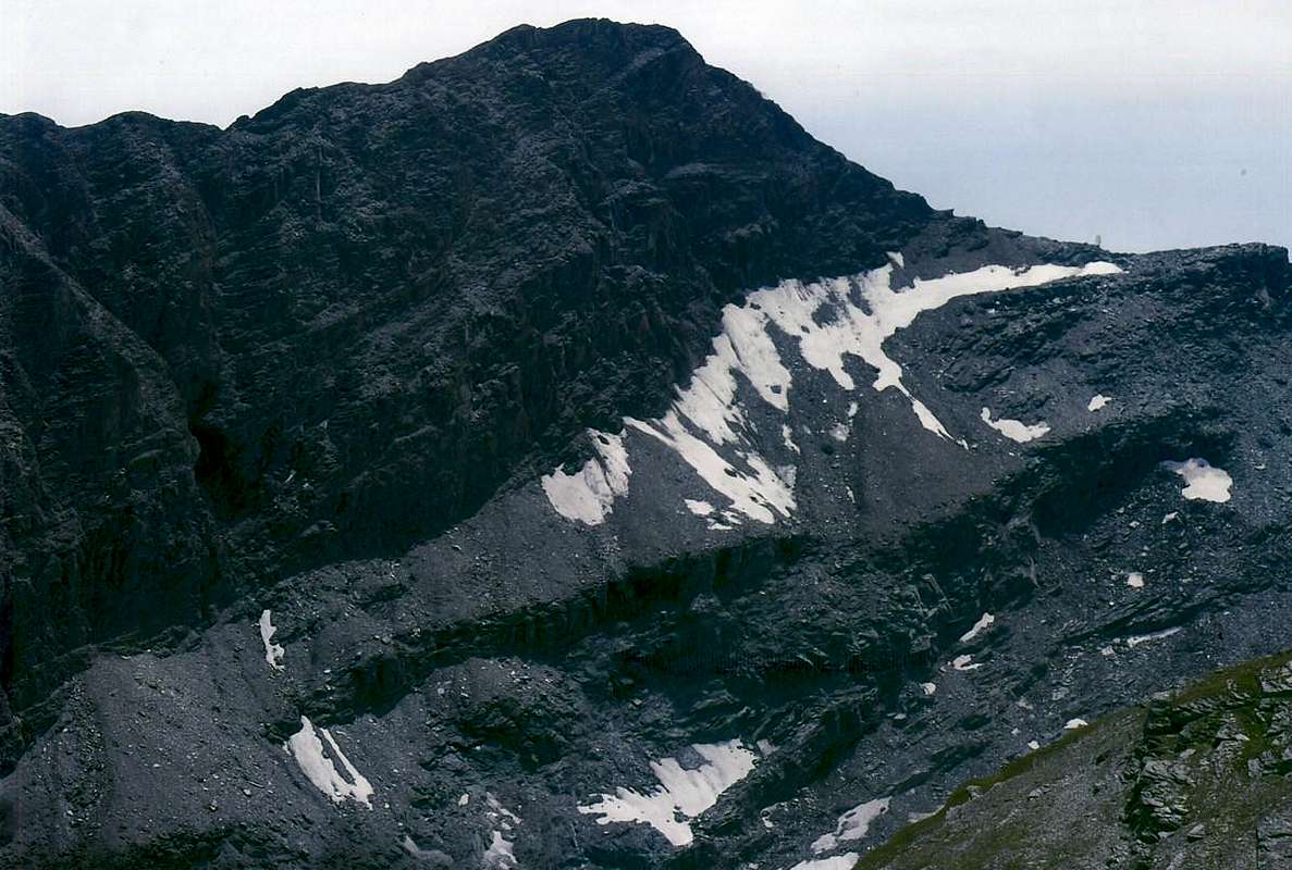
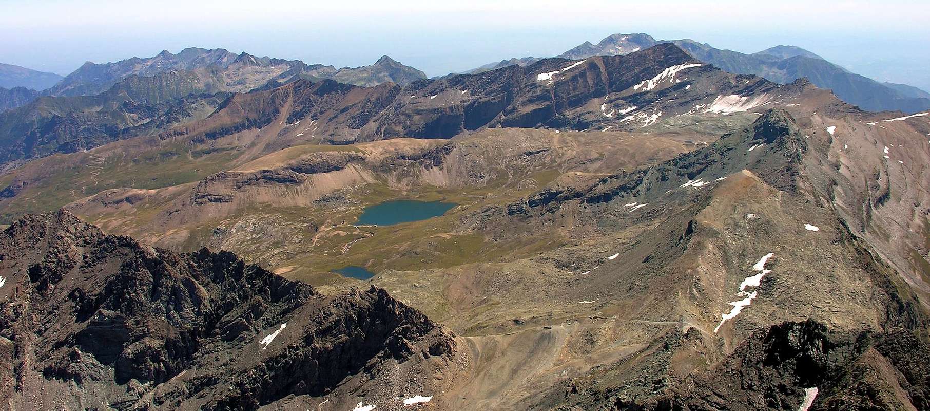
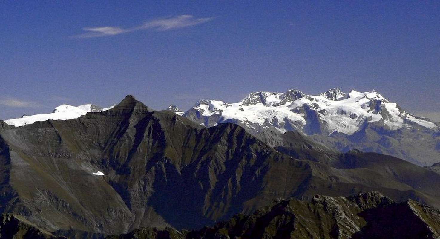
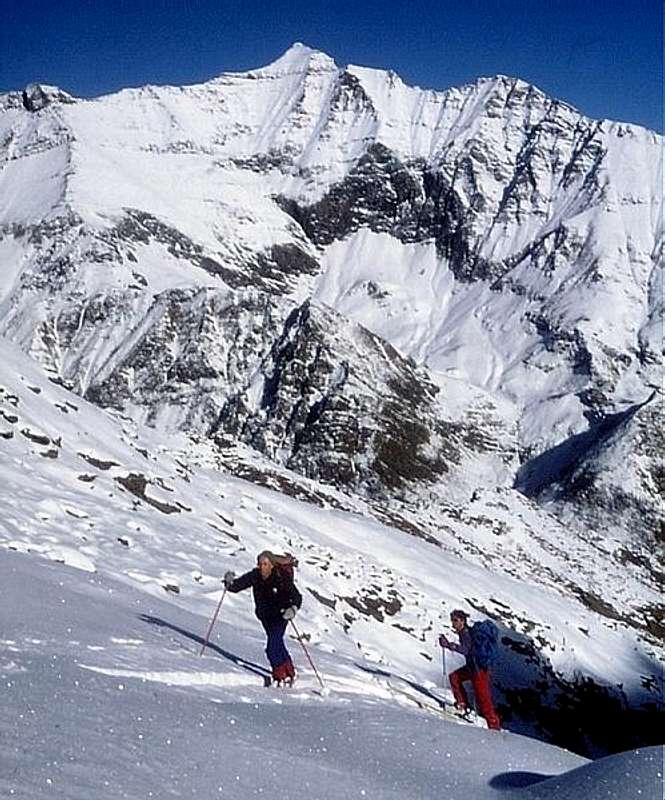
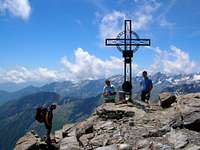
The Rosa dei Banchi (3.164m) is the more representative top of the Valley of Champorcher and the second peak of the small Group of the Mont Glacier (3.186m), even if it is beyond the Torret Ayasse that bisects the valley taking origin from the various lakes below the Fenêtre de Champorcher. The same is reunited with that of Bantses (which comes from the homonymous vallon, and low above the glacier at the Western base of the Rosa dei Banchi) midway between the Pastures of Leituerie and Champlong at the Royal Road to Dondena. This beautiful and ancient mountain is formed by three ridges, which separate the valley from the Piedmont of Azaria (in the Southwest) and Piaprato in Southeast, and as mmany fronts. The first, or West Ridge, down to the Rosa Pass at the height of the Valley of the Banses and is the Normal Route to the Summit Aosta Valley; while on the opposite side (Southern) climbing from the Valley of Campiglia Soana you can also reach Colle della Rosa (2.957m), or with a variant, little known and even less frequented, "cutting" as a shortcut on the steep slopes of the South Slope of the Western Crest reaching the same at '' approximately in its half, anticipating the most exposed passage on the same (around II°, but in any case not convenient choice and much less advisable). The second, addressed to the Northeast, stretches forming the Punta delle Fontane, the various top of the Cime Beccher (2.945m) and the Petit Paradis or Bec Pragelas (2.908m), where it splits into two: one branch continues Northward reaching Bec Pendente (2.826m), while a second projecting further to the East up to the important Laris Pass (2.584m). A final ridge, or South-southeast, separating the small Valley of the Balma West or into Campiglia Soana Valley from that of Borra in the Valley of Piamprato. This is the Standard Route of ascent from Piedmont, even though they are quite numerous climbs through the Northeast Ridge, accessible at various points (especially as Ski-Mountaineering trip to the Cima delle Fontane (3.068m)). The rock that forms is very broken and even in many places crumbling, as incidentally happens to its sides. There are three walls between these ridges: the first revolt in the East is formed by steep slopes often covered with grass, the second in the Southwest towards the Alp La Balma is formed by steep rocks in net decomposition, while the third falls on what remains of the Glacier of the Bantses. The latter is divided into two sections by a barely noticeable but long rocky rib that goes further North: the first goes down facing West over the glacier with an end wall so steep as the route (december 1971 via); the second sector leans more to the North and consists of a steep scree slope (route of july 2007) that rises to be confused, in the end, with the previous year. Good last itinerary of 24 August 2003 with ascent of the long ledge in an oblique diagonal on the N-NW flank of Cima Beccher (2.945m) above Alpe Pian di Roche (2.238m) in the enough quite elongated Vallone dei Banchi, ending in final part on the NE Ridge. This with a fairly safe itinerary between two compact rocky banches (upper and lower, even if it is better to stay at a certain distance from the first), fairly protected from falling stones and not difficult. Surely the only wall that is really challenging climbed in 1971, even though the same is somewhat exposed to falling rocks. Regarding the ridges applies the above, even if there is to report the scenic route via the Northeast Ridge beginning at the Bocchetta of Marmo Bianco (Nozzle of White Marble; 3.091m), located between Cime Beccher and Petit Paradis and usual starting point for this beautiful and easy crossing not too crowded, but definitely worth a visit. In any case, the busiest route remains that from Rosa Pass, via the Western Ridge, on watershed between Piedmont and Aosta Valley. In use as tour Ski-Mountaineering. Good view on Po Valley, in the foothills of East Gran Paradiso Massif and to the Northwest Groups Mounts Avic, Glacier, Punta Tersiva, Emilius and more distant Monte Rosa from Piccolo Cervino to the NW up to Punta Giordani to the S-SE crossing the 4.000 meters of Breithorns, the Lyskamms, P. Zumstein, Dufour and Gnifetti. But above all, the views over the Champorcher Valley below are splendid, which stretches from the SW (Miserin's Area) to the NE until it reaches the Dora Baltea.
La Rosa dei Banchi (3.164 m) è la cima più rappresentativa della Valle di Champorcher, nonché la seconda vetta del piccolo Gruppo del Mont Glacier (3.186 m), anche se si trova al di là del Torret Ayasse che divide in due la valle prendendo origine dai vari laghi sottostanti la Fenêtre de Champorcher. Il medesimo si riunisce con quello dei Bantses (che proviene dall'omonimo vallone e dal ridotto soprastante ghiacciaio alla base Occidentale della Rosa dei Banchi) a metà strada tra gli Alpeggi di Leituerie e di Champlong presso la Strada Reale verso Dondena. Questa bella ed antica montagna é formata da tre creste, separanti questa valle da quelle piemontesi di Azaria (a Sudovest) e di Piamprato a Sudest, ed altrettanti versanti. La prima, o Cresta Ovest, scende verso il Colle della Rosa al culmine del Vallone dei Banchi e costituisce la Via Normale Valdostana alla Sommità; mentre sul lato opposto (Meridionale) salendo dalla Valle di Campiglia Soana si può raggiungere ugualmente il Colle della Rosa, oppure con una variante, poco conosciuta ed ancora di meno frequentata, "tagliare" a mò di scorciatoia sui ripidi pendii del Versante Sud della Cresta Ovest raggiungendo la medesima all'incirca nella sua metà, anticipando il passaggio più esposto sulla stessa (II°, in ogni caso scelta non conveniente e tanto meno consigliabile). La seconda, rivolta a Nordest, si allunga formando la Punta delle Fontane, le varie sommità delle Cime Beccher (2.945 m) ed il Petit Paradis o Bec Pragelas (2.908 m) , ove si sdoppia: un ramo prosegue verso Nord raggiungendo il Bec Pendente (2.826 m), mentre un secondo si proietta maggiormente ad Est fino all'importante Col Larìs (2.584 m). Un'ultima cresta, o Sud-sudest, separa il piccolo Vallone della Balma ad Ovest da quello della Borra nel Vallone di Piamprato. Questa costituisce la Via Normale di salita dal Piemonte, anche se abbastanza numerose sono le ascensioni tramite la Cresta Nordest, raggiungibile in diversi punti (soprattutto come gita Sci-Alpinistica alla Cima delle Fontane (3.068 m)). La roccia che le forma é molto rotta ed addirittura in molti punti sgretolata, come daltronde succede per i suoi versanti. Tre sono le pareti comprese tra queste creste: la prima rivolta ad Est é formata da ripidi pendii spesso ricoperti da erba, la seconda a Sudovest verso l'Alpe La Balma é formata da abrupte rocce in netta decomposizione, mentre la terza precipita su ciò che resta del Ghiacciaio dei Banchi. Questa ultima viene divisa in due settori da una appena evidente ma lungo costolone roccioso procedente più a Nord: il primo scende rivolto ad Ovest sopra il ghiacciaio con una parete terminale tanto ripida quanto rotta (via del dicembre 1971); il secondo settore appoggia più a Settentrione, costituito da uno scosceso versante detritico che sale a confondersi, nella parte finale, con la precedente (via del luglio 2007). Buon ultimo l'itinerario del 24 Agosto 2003 con risalita del lungo cengione in diagonale obliqua sul Versante N-NO della Cima Beccher (2.945 m) soprastante l'Alpe Pian di Roche (3.238 m) nell'abbastanza allungato Vallone dei Banchi, con conclusione sulla Cresta NE. Con itinerario abbastanza sicuro tra due compatte banconate rocciose (superiore ed inferiore, anche se conviene stare ad una certa distanza dalla prima, poiché al di sopra della medesima si trova del materiale sospeso), abbastanza protetto dalla caduta di pietre nonché non difficile. Sicuramente l'unica parete veramente impegnativa é quella percorsa nel 1971, pur se la medesima risulta alquanto esposta alla caduta di pietre. Per quanto concerne le creste vale quanto sovraddetto, anche se v'é da segnalare il panoramico percorso tramite la Cresta Nordest con inizio alla Bocchetta del Marmo Bianco (3.091 m), posta tra le Cime Beccher ed il Petit Paradis ed usuale punto d'inizio per questa bella e facile traversata non eccessivamente frequentata, ma sicuramente meritevole d'una visita. In ogni caso la via più frequentata rimane quella dal Colle della Rosa tramite la Cresta Ovest sullo spartiacque col Piemonte. Buon panorama sulla Pianura Padana, propaggini Orientali del Massiccio del Gran Paradiso e verso Nord sui Gruppi di Avic, Glacier, Punta Tersiva, Emilius nonché il lontano Monte Rosa dal Piccolo Cervino a NO fino alla Punta Giordani a S-SE scavalcando i 4.000 metri dei Breithorns, Lyskamms, P.te Zumstein, Dufour e Gnifetti. Soprattutto son splendide le vedute sulla sottostante Valle di Champorcher, che si distende da SO (Area el Miserin) in direzione NE fino a raggiungere la Dora Baltea.
First Ascent
First on the summit: unknown or Cap. Albert della S.M.S., (1831).
In winter: Scipione Cainer, Adolfo Gervasone and Carlo Ratti, (Feb 14th, 1888).
W Ridge (Standard Via from Colle della Rosa): unknown.
Southern Slope between Colle della Rosa and half of Western Crest (variant): unknown; variant via starting from Campiglia Soana Valley.
W-NW Wall: Alessandro Jaccod, (Dec 28th, 1971).
N-NW Face: Osvaldo Cardellina and Emilio Bertona, (Jun 27th, 2007).
N-NW Face of Cima Beccher and NE Ridge in final part: Osvaldo Cardellina, Emilio Bertona and Nicola Colajanni, (Aug 24th, 2003).
NE Arête (from Cime Beccher): Unknown.
S-SE Arête (from Borra Pass): Unknown.
W-SW Face (Direct Via after descent from Colle della Rosa): Osvaldo Cardellina, Marco Cossard and Giuseppe Lamazzi, (Oct 20th, 1983).
Getting There
BY CAR:
From Torino, Milano, etc: Motorway A5. Exit Pont Saint Martin Commune for then to continue on SS.26 to Hône and Bard Municipalities.
From Switzerland: through the Grand Saint Bernard Tunnel or the namesake pass. Drive to Aosta, Verrès to Hône and Bard Communes.
From France: through Mont Blanc Tunnel or Petit Saint Bernard Pass. It isn't necessary to take Motorway A5 (neighbor Morgex Municipality): you can drive on SS.26, in the direction of Aosta towards Nus, Chatillon, St. Vincent, Verrès, Hone and Bard Municipalities.
Specific Road: from Hône 364m Commune, after crossing on stone bridge above Dora Baltea, to Bard Municipality (566m; renowned Fortress); from thys continue South through Ragional Road with numerous winding road reaching at first after 6,5 Km. Pont Bozet Municipality (775m; 8 fractions; Church of 1600). After other 5 Km. reach Selleret Hamlet, first of Champorcher; leaving left (South) the deviation to Outre l'Eyve and in opposite to Pt./Gr. Rosier Villages, arrives, after 15 Km. from Hone, in the Chief Town of Château (1.427m; Turistic Center & Winter Resort; castle-tower year 1000) and, successively at the end of the valley, up to the Chardonney Fraction (1.455m; 1 Km. Château).
BY PLANE:
Aeroporto "Corrado Gex" Saint Christophe (Aosta).
Road Itineraries
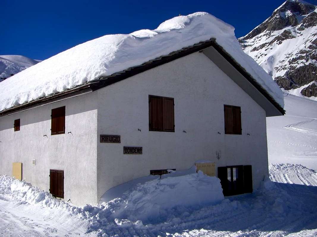
If you take the motorway, exit in Pont St. Martin and follow the direction Aosta along the SS.26; take care after Donnas: right side, immediately after the village, you can see approx. 100 meters of the roman consular road and a nice arc. A few hundreds meters after Hône Municipality (364m; neighbor the Fortress of Bard Commune, famous for having temporarily stopped Napoleon in the Italian Campaign 1800) there is a bridge left side, over the Baltea River, with the indication Champorcher; follow it. Drive a few km, till the village of Château, and look right side for the indication Petit Mont Blanc. Follow this road before in asphalt, not too large, for a few of km. Part is asphalted, the most part no. Usually the conditions of this first part are good. Follow this road till Dondena old Village; at the end a sign forbids the traffic after the parking. Usually the conditions of this second part are good, but it is best to inquire in the area as often (surely after the winter) vary somewhat. Take care and park in the upper zone, definitely wider. When you start walking, you will find a table with the indications, and the map of the area. Come down left till the Torrent of Ayasse, pass over the stone bridge and along the dirt road, passing near an old dilapidated barracks (* which functioned as an secondary outpost, after the Champorcher Fenêtre, to stop the incursions to Bard Fortress of the Army Corps of General Duhesmes by the Austrian Army Suvarow indulged in the defense of the territory by the inhabitants of Valley), arrive in short time to Dondena Refuge (2.097m; 0h'15).
Tramite l'autostrada, uscire a Pont St, Martin e seguire la direzione verso Aosta lungo la SS.26; giunti dopo Donnas si possono ammirare sul lato destro, immediatamente dopo il paese, ancora un centinaio di metri della strada consolare romana nonché un bellissimo arco. Ad altre poche centinaia di metri nel Comune di Hône (364 m nelle vicinanze del Forte di Bard, famoso per aver dal 19 Maggio al 1 Giugno 1800 fermato l'avanzata di Napoleone nella Campagna d'Italia) esiste il ponte sulla sinistra, sopra il fiume Dora Baltea, con l'indicazione Champorcher; passando per il viciniore Comune di Bard 566 m, seguirla. Risalire tramite la Strada Regionale insino al villaggio di Château, e ricercare sulla destra l'indicazione per il Villaggio di Petit Mont Blanc. Seguire questa strada, non troppo grande, per qualche Km. con la medesima asfaltata nel primo tratto e poi sterrata. Di solito le condizioni di questa seconda parte sono buone, ma é meglio informarsi nella zona poiché spesso (dopo l'inverno) variano alquanto. Seguirla fino a Dondena; al termine della medesima e, presso un piccolo parcheggio nelle vicinanze, un cartello vieta il traffico. La strada in pendenza però consiglia di fermarsi in quello appena sopra, inoltre più largo. All'inizio dell'escursione troverete un pannello segnaletico con le indicazioni e la cartina della zona. Da questo discendere verso sinistra fino al Torrent Ayasse per poi oltrepassare il ponticello e proseguire lungo la strada che raggiunge, passando presso una vecchia caserma in rovina (* con la funzione d'avamposto secondario, dopo la Fenêtre de Champorcher, per arrestare le incursioni "alle spalle" verso il Forte di Bard del Corpo d'Armata Francese del Generale Duhesmes da parte delle pattuglie Imperiali Austriache del Generale Suvarow assecondate nella difesa del territorio dagli abitanti della Valle di Champorcher), in breve tempo si arriva al Rifugio di Dondena (2.097 m; 0h'15).
Approaches & Routes
Route A: from Dondena (2.110m) to come down the small bridge on the Torrent Ayasse for the old Real Road, concomitant with the path n° 7B/7C/High Route number 2, to reach the Lake Miserin (2.582m1h'20). From the Lake it travel in South direction, for small gravelly valley, the path n° 7 for the Rosa Pass (2.957m); to direct itself under the Northern Slope of Punta dell'Asgelas and with a enough long diagonal one to Southeast to surpass the small Glacier dei Banchi (a passage of I°+/II°- under the hill asks for caution!).
Variant of the Approach: from Dondena Village to reach the shelter of the same name (2.192m) but, on the right, leaving the dirt farm road to Lake Miserin, instead continue to the South to the next; arriving at a first junction to the Alp Bese (2.239m) let this detour to the West and continue to the junction that leads to the three Pendant Pastures (2.297m, 2.391m, 2.414m). From this point to abandon the farm road and go through the path n° 6C until the next fork in the road to Alp Chila Dèsot (2.370m); discarding this to the East, proceed to the valley floor on the left bank of the torrent of arriving benches near the Quota 2.520 meters, characterized by a great boulder that is overcome by a search for transition between wet rocks and broken. Continue, with no footpath along little evident traces that cross several small emissaries of Bantses Glacier reaching an area of large, dark rock slabs polished by the withdrawal of the same; reached the last part, gradually move to the right, reaching through a small dewlap, the lower edges. Continuing toward the Southwest and through a variety of "clapeys" (large blocks) get stuck in the snow the previous route through a short right diagonal followed by easy direct ascent. From the pass it travel the West Crest (Standard Route from Champorcher-Dondena) surpassing stand out for a ledge on the Campiglia (Piedmont) with a passage of II° enough exposed and requiring caution especially with fresh snow and you can work around but also to the North by means of a step more difficult than initially takes place with a short descent. Continuing on thread of edge or immediately below to right (South) through debris and broken rocks and with a small track easily it is reached the Summit (4h'00). Descent: on the same route also with traverse through the Northeast Ridge to Bocchetta del Marmo Bianco, above Higher Alp Pendant.
Via A: da Dondena (2.110 m) scendere al piccolo ponte sul Torrente Ayasse per la vecchia Strada Reale, concomitante con il sentiero n° 7B/7C/Alta Via numero 2, raggiungeendo il Lago Miserin (2.582 m1h'20). Dal Lago percorrere in direzione Sud, per valloncelli detritici, il sentiero n° 7 per il Colle della Rosa (2.957 m); dirigersi sotto il Versante Settentrionale della Punta dell'Asgelas e con un diagonale abbastanza lungo a Sud-est superare il piccolo Ghiacciaio dei Banchi. Un lastrone instabile di I°+/II°- appena al di sotto del colle richiede attenzione e lo si supera tramite una larga "spaccata" in un piccolo diedro-camino facendo bene attenzione agli appigli ed agli appoggi, sempre precari.
Variante d'Avvicinamento: dal Villaggio di Dondena raggiungere l'omonimo rifugio (2.192 m) ma, lasciando sulla destra la strada poderale per il Lago del Miserin, continuare invece verso Sud con la successiva; arrivando ad un primo bivio per l'Alpe Bese (2.239 m) lasciare questa deviazione ad Ovest e continuare sino al bivio che conduce alle tre Alpi Pendant (2.297 m, 2.391 m, 2.414). Da questo punto abbandonare la strada poderale e salire tramite il sentiero n° 6C fino al successivo bivio per l'Alpe Chilà Dèsot (2.370 m); scartando questa verso Est, procedere invece sul fondo del vallone sulla sinistra idrografica del Torrente dei Banchi arrivando nei pressi della Quota 2.520 metri, caratterizzata da un grande masso, che si supera con una ricerca di passaggio tra rocce umide e rotte. Proseguire, senza più sentiero, lungo poco evidenti tracce che attraversano i vari piccoli emissari del Ghiacciaio dei Banchi pervenendo ad un'area di scure banconate rocciose levigate dal ritiro del medesimo; piacevolmente risalirle e, giunti al culmine, gradualmente spostarsi verso destra o Sudovest raggiungendo, tramite una piccola giogaia, i bordi inferiori dello stesso. Continuando sempre nella stessa direzione e superando una serie di "clapeys" (grossi blocchi) infilati nella neve, a volte pericolosi perché instabili, raggiungere la precedente via tramite un breve diagonale ancora a destra seguito da salita diretta. Dal colle percorrere la Cresta Ovest (Via Normale da Champorcher-Dondena) superando un risalto per una cengia sul versante Campiglia (Piemonte) con un passaggio di II°, abbastanza esposto e richiedente cautela sopattutto con neve fresca ed aggirabile anche a Nord ma per mezzo d'un passaggio più difficile che inizialmente avviene con una corta discesa. Continuando più facilmente sul filo di cresta od appena al di sotto sulla destra (Sud) tramite rocce trite ed una piccola traccia facilmente si raggiunge la Vetta (4h'00). Discesa: lungo la stessa via di salita altrimenti tramite traversata sulla Cresta Nordest verso la Bocchetta del Marmo Bianco, sopra l'Alpe Pendant Superiore.
Route B: from the junction to the Alps Pendant continue through the dirt road, concomitant with trail n° 6 until the next fork in the dirt road to Alp Chila Désot (Lower; (2.370m), reaching the same and the above Alp Pendant III° or Higher, located on the Northwest slopes of Bec Pendant. From this go up to Southeast first through meadows with scattered blocks and then through a track that climbs the steep but easy North side of the Nozzle of the White Marble (2.901m); reached this large saddle, climb on the next watershed to the Quote 2.931 meters, or avoid it just to the left (Southeast). Continue easily along the ridge to the nearby Northern Cima Beccher (2.940m) through broken rocks and proceed to the next (2.973m, 3.038m, 3.068m; cairn) or Beccher Southern Peaks with the same characteristics as the path above in a vertical wall facing West-southwest on the extreme appendages Glacier of Bantses. From this point, flexing slightly to the left (South), the ridge forms a fairly wide saddle characterized by large blocks. After a short descent and have passed through the same, you are returned to the primary direction of reaching a secondary elevation above a small notch or carving; crossing the same on large slabs and blocks, and then returned to the ridge edge and smashed by rocks you will come to another elevation, called the Cima delle Fontane (3.084m; arrival point for trips departing by Ski-Mountaineering from Piamprato). Climbed over the hump after also rounded up later and another more pointed and tiny, with a view to the Summit at last, by a sudden more aerial and exposed to the East to reach the final part; this is exceeded, bypassing a section of steep rocks to the West (I°+/II°-) to conclude more easily in the end to the Summit (EE/F +; 1h'15 from the "Bocchetta"; 2h'00/2h'15 from Alp Pendant; 3h'30/4h'00 from Dondena Shelter or Dondena Village).
Via B: dal bivio per le Alpi Pendant continuare tramite la stada poderale, concomitante con il sentiero n° 6 fino al successivo bivio per l'Alpe Chilà Dèsot (2.370 m) raggiungendo la medesima e la sovrastante Alpe Pendant III° o Superiore, posta alle pendici Nordoccidentali del Bec Pendant. Da questa dirigersi a Sudest dapprima attraverso prati con blocchi sparsi e poi tramite una traccia risalente il ripido ma facile Versante Nord della Bocchetta del Marmo Bianco (2.901 m); raggiunta questa larga sella salire sullo spartiacque la successiva Quota 2.931 metri, oppure evitarla immediatamente a sinistra (Sudest). Continuare facilmente in cresta verso la vicina Cima Beccher Settentrionale (2.940 m) tramite rocce rotte e proseguire verso le successive (2.973m, 3.038m, 3.068m; ometto di pietre) o Cime Beccher Meridionali con le medesime caratteristiche di percorso al di sopra d'una parete verticale rivolta ad Ovest-sudovest sulle appendici estreme del Ghiacciaio dei Banchi; da questo punto, flettendo leggermente a sinistra (Sud), la cresta forma un'abbastanza larga sella contraddistinta da grandi blocchi. Dopo breve discesa ed averla attraversata, si ritorna alla primaria direzione raggiungendo un'elevazione secondaria precedente un intaglietto; attraversando il medesimo su grandi lastre e blocchi per poi rientrare sul filo di cresta e tramite rocce sfasciate si perviene ad un'altra elevazione, detta Cima delle Fontane (3.084 m; punto d'arrivo per le gite Sci-Alpinistiche con partenza da Piamprato). Scavalcata anche l'arrotondata gobba successiva ed un'altra più aguzza e minuscola, con finalmente in vista la Cima, tramite un tratto più aereo ed esposto ad Est raggiungere la parte finale; questa si supera aggirando un muretto di rocce ripide ad Ovest (I°+/II°-) per concludere più facilmente nella parte terminale (EE/F+; 1h'15 dalla Bocchetta; 2h'00/2h'15 dall'Alpe Pendant III°; 3h'30/4h'00 dal rifugio o da Dondena).
Difficulties
These routes can be considered PD- and F+.
I due itinerari sono da classificarsi in PD- e F+.
"Guida delle Alpi Occidentali" di Giovanni Bobba e Luigi Vaccarone C.A.I. Sezione di Torino Volume II (parte II), 25 Maggio 1896.
"Guida dei Monti d'Italia–Emilius Rosa dei Banchi Parco del Mont Avic" di Giulio Berutto e Lino Fornelli-Club Alpino Italiano/Touring Club Italiano, Marzo 2005 (in Italian).
"I Rifugi della Valle d'Aosta" di Stefano Ardito, Ed. Guide iter, Febbraio 2003.
"Guida della Regione Autonoma Valle d'Aosta" di Mario Aldrovandi; Ed. S.P.E. di Carlo Fanton, Torino 1964.
"Diari Alpinistici" di Osvaldo Cardellina e Indice Generale accompagnato da Schedario Relazioni Ascensioni 1964-2021 (inediti).
MAPS:
Enrico Editore Ivrea-Aosta "Gruppo del Gran Paradiso" 1:50.000.
I.G.C. Istituto Geografico Centrale Torino "Ivrea Biella e Bassa Valle d’Aosta" (n° 9), 1:50.000.
L'Escursionista "Valle di Cogne Carta dei Sentieri" 1:25.000.
Parents refers to a larger category under which an object falls. For example, theAconcagua mountain page has the 'Aconcagua Group' and the 'Seven Summits' asparents and is a parent itself to many routes, photos, and Trip Reports.

 8637 Hits
 85.36% Score
 20 Votes