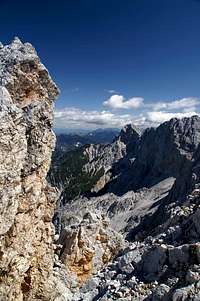
Špik
![Spik south face]() Spik south face - the worn parts indicate the route Spik south face - the worn parts indicate the route |
The most famous, most important, most impressive, highest and most climbed mountain in Slovenia is Triglav, no doubt about it. But if you look for number two there are several contenders. Škrlatica might be the second highest one, Jalovec might be most beautiful one or Mangart might be the most climbed one – it would be hard to put up a ranking among these mountains. If you tried nevertheless, you’d certainly include a mountain, called Špik, into the ranking and if you ask me, it might be rated at the top, after all.
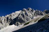
Špik, my guidebook tells me that the name means “spearhead”, and this is exactly what the mountain looks like. Regardless from which side you look at it, its summit looks like a perfect pyramid. The most famous view is from the north, from the villages of Gozd Martuljek or Srednji Vrh, where it dominates the vista of the Martuljek Group though it is not the highest mountain - by far. Thanks to its location, slightly to the north of the group, Špik can be seen from many of the surrounding summits and – consequently – is a perfect lookout peak itself.
![Spik east and north faces]() Spik east and north faces Spik east and north faces | ![Špik]() Spik south-east face Spik south-east face | ![Spik west face]() Spik west face Spik west face |
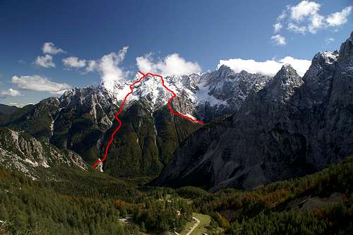
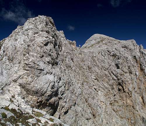
Can such a mountain be climbed by hikers? The steep pyramid has a week spot – high up on its south face a ridge, which starts at neighbouring Lipnica, joins and from that ridge roughly 100m remain to be climbed to reach the summit. There are two routes leading to this ridge, one direct through Kačji graben (the snake gully) and one from Krnica Hut in upper Pišnica Valley. The former is very steep and topped by a steep scree slope while the other is very long and reserves two moderate climbing sections at its top. Both routes can be combined in a loop but it takes a long day to complete it. This is the report of such a long day, a day which started long before dawn and which ended as the sun was disappearing beneath the western horizon.
![Ascent and descent routes to Spik]() Kačji graben route (left), Krnica route (right)
Kačji graben route (left), Krnica route (right)Dawn
Thanks to daylight saving time it is still dark at 6:15 a.m., on a morning in mid September. Getting up gets more difficult day by day but today’s climbing goal, Špik ensures that I’m immediately awake. I pull on what I have and troop outside to jog to the bakery down the road, 500m, which will give me a feel for the day. It’s crisp and cold and I start freezing beneath my fleece jacket, so I step up and hurry along.
The night has been cloud-free and perfect and even now, while a silvery rim lines the horizon in the east, millions of stars are shining down on the town of Kranjska Gora. In the south, the three biggies of the town, the mountains Razor, Prisojnik and Mojstrovka are towering above the valleys. The white limestone with rests of snow is glimmering beneath black skies. There won’t be a better day than this for climbing the most impressive peak of the Julian Alps.
![Dawn]() Razor and Prisojnik at dawn
Razor and Prisojnik at dawn
Entering the bakery I realize it is still not yet 6:30 when they open but nevertheless I’m greeted by a big smile. The girl behind the counter makes me drift back in time, dreaming about my plans and wishes when I had not yet turned twenty. As I leave the shop with the bag of rolls in my arm reality pushes me back to here and now – I overlook a step outside the shop and step down hard. Nothing softens the shock and it gets transferred to my spine, hurt spreading like a wildfire. Damn – I’m middle aged now – and all the smiles of the world won’t turn back time.
I turn back and look up to where I suppose Špik must be. From Kranjska Gora you can only see its very summit. The famous face is hidden by the lower summits up front, mainly Frdamane Police. The silver lining on the eastern horizon has not changed much yet as I jog back to the apartment through the cold. I’m glad the water is already boiling and we settle into our short breakfast routine. Eat drink, then prepare food and drink, pack everything in the pack and don’t forget the sweets. Today we’ll reach out high and we put a lot of clothing in the pack.
Our plan is to drive to the trailhead some 6km south of Kranjska Gora, then take the short route up Kacji graben to the top and descend along the long southern route. I hope to be on top early in order to get some decent photos of the Julian peaks in the south. Wait or take too long and the sun will spoil all views southward. In the north there are only the lower western Karawanken peaks, maybe the Hohe Tauern Range in the far distance. The real show will be south and west.
After five minutes we reach the trailhead right where the Vršič pass road crosses the Pišnica River. We get ready quickly and shortly after 7 a.m. head out Pišnica Valley. We follow a dirt road which leads to Koča v Krnici, the hut which stands close to our descent route. We’ll have to turn east after some 2km into Kacji graben, which will lead directly towards our summit. Kacji graben means snake gully and our guidebook warns us not to leave the trail because of venomous snakes. At this time of the day and the year, however, it is so cold that snakes will probably be the least of our problems.
Still on the road we witness the sun rise on Razor and Prisojnik, while we shiver in the shade. The two mountains glisten in the early morning sun, an impressive spectacle with everything else hidden in the shadows. I waste half a dozen photos on the motif and have to hurry after Judith, who keeps on heading along without waiting for the silly freezing photographer.
Sorry, No Snakes
I catch up with her at the intersection with the Kacji graben route and we gain elevation quickly. We seem to be heading along to the south of the gully. Views towards Razor and Prisojnik get even better and Mala Mojstrovka appears above the Pišnica Valley in the west. I’m a bit disappointed because I was prepared for some chimney-like climbing and now I’m simply hiking up steep slopes. The path turns northward a bit and plunges into the shadows of the trees. Everything is hidden from view again and we concentrate on the route instead. Over night it has become wet and some of the sections are quite slippery. It reminds me of last year’s hike to Tuxer Joch in the Zillertal Alps but luckily mountain bikers are missing from this route today.
A protected section leads up some bigger steps and we smear our way up. I decide I wouldn’t want to descend this route in these conditions and feel glad that we do the tour the other way. Finally we have come into what could be called a gully, but it definitely lacks snakes. Too bad – I would have liked to take some photos…
![Vrh nad Rudo (2114m)]() Vrh nad rudo Vrh nad rudo | ![Saddle View]() Saddle View Saddle View | ![Frdamane Police (2284m)]() Frdamane police Frdamane police |
Another step and the trees retreat a bit for a while. We find ourselves alongside the south face of Vrh nad rudo, the westernmost of the Špik satellites. It hovers above us and gleams in the morning sun. A few steps more and the trees close in again but it becomes clear that this is their last effort. We’re walking on scree and finally the woods retreat. We are at the height of the saddle between Vrh nad rudo and Frdamane Police, through which we can see a couple of summits of the Hohe Tauern Range. Might this be Hochschober?
As we get out on the scree I turn around and see Prisojnik rise above our route. Up front lie the jumbled rocks of Frdamane Police and ahead we see Špik’s ugliest face, the south-western one. We reach some snow fields, which – without crampons – pose a serious obstacle. We manage to negotiate them, not without slipping once or twice. I’m having trouble with the heavy backpack while Judith rushes along ahead of me quite easily.
Looking west towards Prisojnik, Jalovec, Mangart and Montasio |
Above the snow we hit scree and soon we wish we were back on snow. It’s one step back for every two steps up. With the steepness of the slope and my heavy pack I’m desperately trying to keep my balance. Every 50m I have to take a break and use it to take in the gradually developing views. I like what I see. Currently only the western Julian Alps are visible but with every step the panorama widens. To my left Frdamane Police already starts to grow smaller as I head for the topmost part of the scree slope.
Summit Pleasures
While I’m stumbling upwards I’m happy that nobody is around to rate my performance. Judith is struggling 100m ahead of me and there is nobody else around. But wait! I hear voices! Taking one of my breaks I look up and see a couple on the ridge between Lipnica and Špik. Their moves look like gymnastics from my vantage point and it takes a while until I realize that they are on our descent route. It’s going to be fun! While they are still quite far off from the intersection of our routes they still will be there before us. If anything, our scree slope is getting steeper still, a path is worn out and you have to climb big step through the scree. We slow down to almost standstill.
![Prisojnik]() Prisojnik Prisojnik | ![Pelc nad Klonicami (2442m)]() Pelc nad Klonicami Pelc nad Klonicami | ![Frdamane Police (2284m)]() Frdamane police Frdamane police |
The other two now prepare for the final ascent, hiding their hiking poles somewhere near the route intersection. They watch our struggling for a while, then turn towards the summit. After a few steps – I watch this during my frequent breaks – they stop and I realize that another couple is descending from Špik. Maybe after all, the summit will be crowded. We finally leave the scree and climb up towards the summit route. “Dober Dan” – the descending couple pass us on their way down. They take our descent route and thus confirm that we have to negotiate the ridge to the south. We fix our poles on my backpack, watching them leave.
![Jalovec]() Jalovec Jalovec | ![Mangart, Jôf di Montasio]() Mangart, Montasio, Pelmo Mangart, Montasio, Pelmo | ![Kukova Spica (2427m), Dovski Kriz (2542m), Velika Ponca (2592m)]() Kukova Spica, Dovski Kriz, Velika Ponca Kukova Spica, Dovski Kriz, Velika Ponca |
Another step and the trees retreat a
While I watch the two disappear, first down, then around a corner, Judith already tackles the remaining 100m. I follow, putting my faith in the protection, the guidebook promises for this final section. There is none at the base of the section and we cover some tricky, broken terrain, heading for the south ridge proper. There are no protections on the ridge either and honestly, it doesn’t look as if there have ever been any. Not around here, anyway. Still musing about this lacking protection and fighting against the pull of the backpack, which finally has developed a life of its own, trying to draw me down again, I lose track of how far I have got. Judith is saying something which I don’t catch. I ask what it was before looking up and when I finally do I realize I have arrived on the summit and that she was only polite to the other two people on the summit: “Dober Dan – Good Day”.
360°-Panorama Spik (This might take some patience to display correctly)


 |
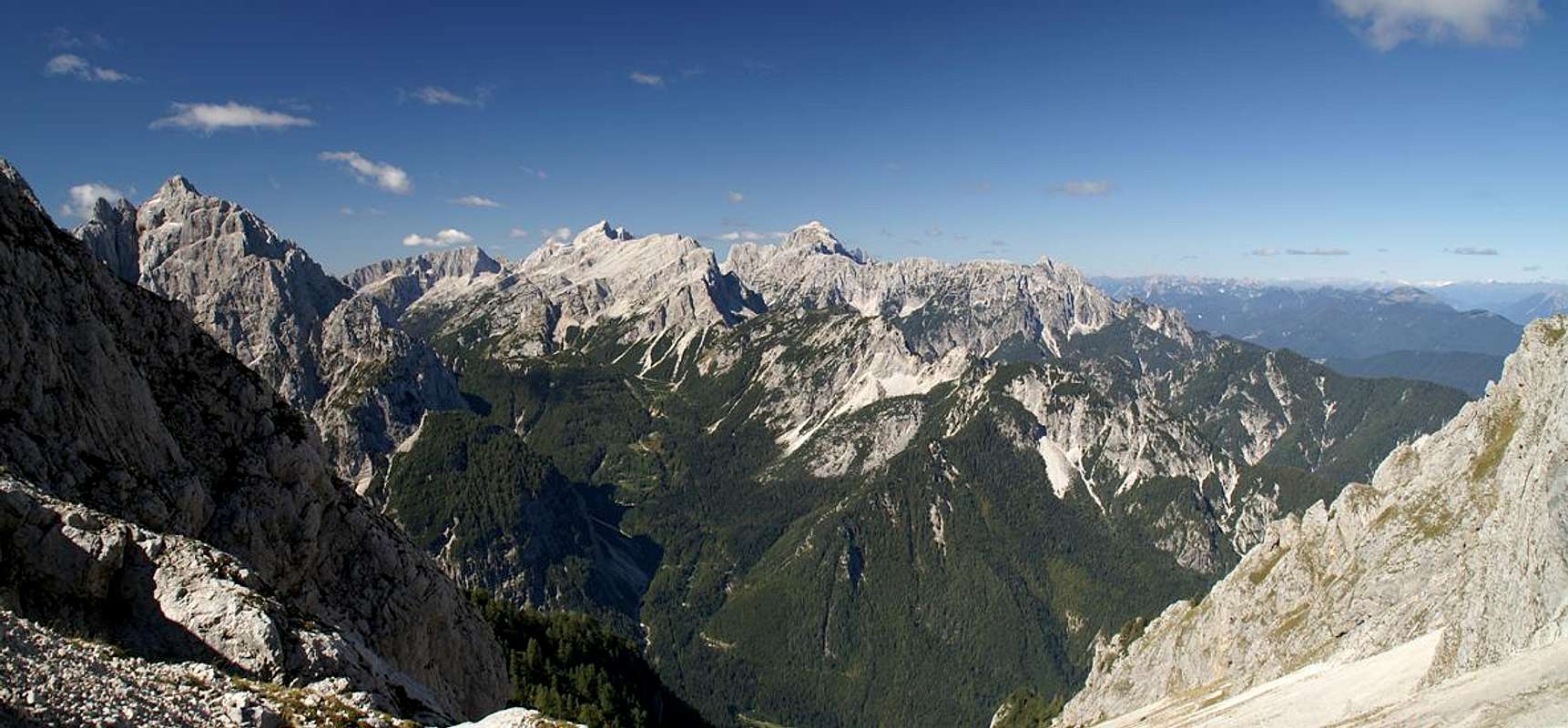
Coming to the top at unawares I’m blasted away by the views – the southern and western half is taken by the Julian Alps, close-up views of the Martuljek Group and midrange views toward the Razor/Prisojnik and Jalovec/Mangart Groups. To the north there are the chains of the Karawanken and the Carnic Alps and beyond that the glaciated peaks of the Hohe Tauern and Zillertal Alps Ranges. To the east – behind Mangart and Montasio you can distinguish the Groups of the eastern Dolomites – Pelmo, Antelao, Marmolada, Dolomiti di Sesto. I watch and watch, then pick out the camera and it starts clicking by itself.
![Prisojnik]() Prisojnik
Prisojnik
By the time I come to my senses, Judith is already done with her lunch and is enjoying her daily dose of chocolate. I walk over to her and start munching myself. The usual scavengers are there, alpine choughs, which, being fed by the Slovenian couple on the other side of the summit, get very annoying after a while. Judith starts throwing stones and the birds repair to the other side. I pick up guidebook and map and try to prepare for the descent. I read the summit section again – and there it is – the book speaks of protection. I pick up the second guidebook – protection again. I must have missed it somehow.
![Curiosity]() Scavenger
Scavenger
The other couple prepares for descent, “good bye” and off they go. I put all my photo gear back in the pack trying to follow close.
Lipnica
Descending the Špik summit happens as quickly as did the ascent. In no time we have negotiated the rotten section of the south ridge, head over to a shallow gully and are back at the intersection with our ascent route. The Slovenian couple already is down on the scree and seem to be having trouble with it. I’m glad I don’t have to follow them.
![Ridge toward Lipnica]() The ridge to Lipnica
The ridge to Lipnica
But is our route really the better one to descend? We traverse a rocky section, then climb down for some meters, then back up again – there is even a fixed cable here – and then scramble along on the western side of the Špik south ridge. There is no protection but the path is marked and we follow it, trying not to think of what is beneath us. Especially the eastern side of the ridge – the one we can’t see from where we are – had appeared very exposed when seen from the top. On our side a fall would end somewhere on the scree some 40m below.
![Kukova Spica]() Kukova Spica Kukova Spica | ![Dovski Kriz (back, 2542m), Velika Ponca (2592m)]() Velika Ponca Velika Ponca | ![Frdamane police]() Frdamane police Frdamane police |
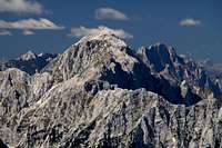
As we negotiate the path, using all our hands and feet we finally reach its top. The view to the east is outrageous – a jumble of rocks between us and the Poncas (Mala Ponca, Velika Ponca), Oltar and Dovški Križ. The rocks deep down beneath us look razor sharp – like the shards of broken bottles – only much, much bigger. We top out on a summit plateau and realize that we have reached Špik’s closest neighbour, Lipnica. Views up here are even more impressive than the ones from Špik half an hour ago. Špik dominates the northern aspect while all around the Martuljek Mountains close in on us.
![Descending Lipnica]() Descending Lipnica
Descending Lipnica
After a short break we search for the descent path and finally find it to the south, where the plateau narrows to form a broad but short ridge. At its end it suddenly drops for about 50 – 100m. Luckily here the guidebook is correct – there is a little ferrata and we quickly descend towards a little saddle. From down here, where we are close to the jumbled rocks, the view towards Mala and Velika Ponca is breathtaking. Limestone rocks of all shapes and colours are heaped on top of each other, giving a very wild impression.
![Lipnica]() Mini Ferrata (left) towards Lipnica (right)
Mini Ferrata (left) towards Lipnica (right)A Long, But Beautiful Descent
![Mangart]() Precariously placed menhir
Precariously placed menhir
We turn westward towards Gamsova Špika, a ridge deep underneath us. The path is supposed to circle around it but currently we don’t see where this could be. After a few meters we walk through a couple of gendarmes, zig back, zag forth and suddenly there is a menhir-like rock precariously balanced on the steep slope. Mangart can be seen behind it in the distance as I grab the camera and take a shot.
Each turn of the switch-backing path offers new views, some near, most far and we somehow forget that our bones and muscles start getting sore. We have climbed already 1750m and will have to go all the way down again. Currently at about 2000m we know that we’ll have to go down another 900m before we reach Koca v Krnici, from where a dirt road will lead back to our trailhead. Still, currently we don’t worry. Yet!
![Visoka Ponca / Ponza Grande]() Visoka Ponca / Ponza Grande Visoka Ponca / Ponza Grande | ![Gamsova Spica]() Gamsova Spica Gamsova Spica | ![Skrlatica (2740m), Rakova Spika (2545m), Dovski Gamsovec (2440m)]() Skrlatica, Rakova Spica, Dovski Gamsovec Skrlatica, Rakova Spica, Dovski Gamsovec |
Gamsova Špica draws near; from above it looks like a short ridge of low but spiky summits. However, a chimney between the easternmost of them reveals that on the other side it drops away dramatically. We pass the mountain on its northern side, then climb down and down until we reach its north-western base. Here we turn eastward – and right – seen from here Gamsova Špica shows a huge vertical face. We pass underneath it with an occasional glance up but the day is far advanced now and we surely need to hurry now.
The next remarkable feature of the terrain is a giant scree slope. Our path runs towards it and it becomes evident that we have to cross it. Luckily the path is used quite often so that the traverse turns out to be far less annoying than we had thought. However, it is very long and somehow doesn’t seem to end. On and on it goes and instead of turning west to Koca v Krnici we head southward end up in a dry creek bed right underneath the Škrlatica north face.
Dusk
There is still light where we are but as we finally turn westward we realize that from here onwards we’ll be in the shadows of the towering mountains. The path heads into the creek bed, there are no marks anymore; only occasional cairns show the way. Or ways – there appear to be multiple possible ways through this creek, all requiring all attention. It is dark down here and the steps you have to take are often quite big. We don’t want to fall so close to the hut we’re aiming for. Close? We are still 300m above the hut. This takes forever!
The paths recombine and lead out of the creek bed to the north. The creek drops away quickly while we climb a shoulder, then zigzag our way down. We regain the bed after a while, then cross it and finally climb back up on its shore to where, hidden in the trees, Koca v Krnici is lying. The hut is closed – it is September after all – but sunshades indicate that on a weekend we probably would have had a chance of refreshment.
We have been hiking through the shade for about an hour now and it gets darker and colder by the minute. Only the mountains get some light. Down here where we are darkness reigns. My tired eyes wander up towards the east – Velika Ponca is gleaming in front of a dark blue sky. So is the ridge between Oltar and Dovški Gamsovec, which is obscured by trees from where I look.
![Velika Ponca]() Velika Ponca Velika Ponca | ![Dovski Gamsovec]() Dovski Gamsovec Dovski Gamsovec |
After having pulled on another layer of clothing (my pack is finally getting lightweight again, we head for the road which will take us back to the car. It winds down on the western side of the Krnica Valley and we trudge along. Basically our way is lighted by the mountains above – the white limestone glistens in all colours – it hurts your eyes if you look at it longer.
After half an hour the road crosses the river bed and finally – here in the middle of the creek bed – I can get a glimpse of the whole ridge in the south shining in my back. I stop and take the last picture of the day; one that I hope will show the beauty of the situation.
![Dusk]() Skrlatica, Rakova Spika, Dolkova Spika, Dovski Gamsovec at dusk
Skrlatica, Rakova Spika, Dolkova Spika, Dovski Gamsovec at dusk
Afterwards I hurry, trying to catch up with Judith, hoping it won’t be far to the car anymore. I only want to sit down now, sit – not hike, sit, Sit,
SIT!


Comments
Post a Comment